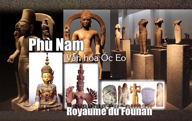
Vương quốc Phù Nam (Royaume du Founan)

founan

Version française

Vương quốc Phù Nam

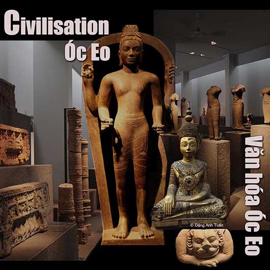
Cho đến đầu buổi bình minh của thế kỷ 20, mới có sự  thông báo về vương quốc Hindu cổ này trong vài văn bản chữ Hán. Vương quốc cổ nầy được đề cập lần đầu tiên vào thời Tam Quốc (220-265) qua một văn bản  chữ Hán vào lúc có sự thiết lập quan hệ ngoại giao của nhà Đông Ngô  với các nước ngoại bang. Trong báo cáo này, người ta có biên chép rằng thống đốc của hai tỉnh Quãng Đông và Bắc Kỳ tên là Lu-Tai có cử các đại diện (congshi) đến các vùng ở phía nam của nước ông. Các vua ở các vùng nầy trong đó có nước Phù Nam, Lâm Ấp và Tang Ming (một quốc gia được xác định ở phía bắc của Chân Lạp vào thời nhà Đường), cũng có từng gửi một sứ giã đến cống vật cho Lu Tai. Sau đó, nước Phù Nam cũng được nhắc đến trong các biên sử từ nhà Tấn cho đến nhà Đường. Tên Phù Nam đây là phiên âm của từ cổ bhnam (núi) của người Khờ Me trong chữ Hán. Tuy nhiên, điều này cũng tạo ra sự dè dặt và nỗi e ngại của một số chuyên gia về việc giải thích từ « Phù Nam » với  từ « núi ». Họ nhận thấy từ Phù Nam theo nghĩa « gò » nó  đúng hơn trong sự biện minh bởi vì với thời gian gần  đây, trong các cuộc nghiên cứu dân tộc học [Martin 1991; Porée-Maspero 1962-69] người Khờ Me thường có thói quen thực hành các nghi lễ xung quanh các gò nhân tạo. Người Hoa không biết phong tục này nên họ ám chỉ đến cách thức thực hành này để chỉ định vương quốc này. Nhờ các cuộc khai quật khảo cổ bắt đầu vào năm 1944 tại Óc Eo thuộc tỉnh An Giang ở miền nam Việt Nam hiện nay dưới sự hướng dẫn của ông Louis Malleret  thì không còn sự nghi ngờ  nào nữa về sự tồn tại và thịnh vượng của vương quốc Ấn Độ hóa này. Những kết quả thu thập từ các cuộc khai quật này đã được ghi chép trong luận án tiến sĩ của ông, sau đó còn được công bố  trong một cuốn sách có tựa đề là « Khảo cổ học của đồng bằng sông Cửu Long« . Nó bao gồm được 6 tập.

Oc Eo

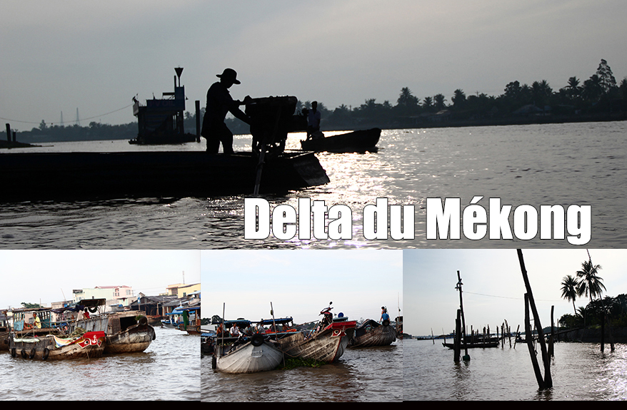
Điều đó mới có thể xác minh được các dữ liệu của người Hoa và càng làm rõ ràng hơn  trong việc giới hạn địa phận của vương quốc nầy. Vì tìm ra được rất nhiều các vật khảo cổ bằng thiếc nên nhà khảo cổ Pháp Louis Malleret không ngần ngại dùng tên Óc Eo để chỉ định văn hóa đồ thiếc nầy. Bây giờ  mới bắt đầu có một ánh sáng rực rỡ trên vương quốc này cũng như về các mối quan hệ bên ngoài của nó trong quá trình nối lại các chiến dịch khai quật được thực hiện với các é-kip Việt Nam (Đào Linh Côn, Võ Sĩ Khải, Lê Xuân Diêm) cũng như với é-kip Pháp-Việt dưới sự hướng dẫn của Pierre-Yves-Manguin từ năm 1998 đến 2002 trong các tỉnh An Giang, Đồng Tháp và Long An, những nơi mà tìm ra được nhiều di tích của văn hóa Óc Eo. Được biết Óc Eo là một hải cảng quan trọng của vương quốc này và là trung tâm thương mại một mặt giữa bán đảo Mã Lai và Ấn Độ và mặt khác giữa sông Mê Kông và Trung Quốc. Khi những chiếc thuyền của khu vực không thể đi được quãng đường dài và phải đi dọc theo bờ biển, Óc Eo trở thành vì thế một lối đi bắt buộc và cũng là một chặng chiến lược trong suốt 7 thế kỷ sung túc và thịnh vượng của  xứ Phù Nam.  Vương quốc nầy có một chu vi hình tứ giác giữa vịnh Thái Lan và miền tây của đồng bằng sông Cửu Long (Transbassac) ở miền nam Việt Nam. Nó được bao bọc ở phía tây bắc bởi biên giới Kampuchia và về phía đông nam bởi các thị trấn Trà Vinh và Sóc Trăng. Những bức ảnh được người Pháp chụp từ trên không vào những năm 1920 mới tiết lộ rằng Phù Nam là một đế chế hàng hải (hay một cường quốc hải dương).Theo các tác giả Trung Hoa, các thành phố tự trị nầy được bao bọc bởi các thành lũy và các mương đầy cá sấu, nối tiếp kề nhau và được chia ra thành nhiều khu nhờ sự rẻ nhánh các kênh rạch và các đường giao thông. Người ta có thể hình dung được những ngôi nhà cùng các cửa hàng nhà sàn có ở chung quanh các thuyền đậu như ở thành phố Ý Venise hay ở các thành phố của miền bắc Âu Châu. Qua mạng lưới đáng kinh ngạc này được tạo thành từ các dãy kênh rạch được bố trí dọc thẳng  theo hướng đông bắc /tây nam (từ sông Hậu ra biển)  và liên lạc thông qua với nhau, ngừời ta khám phá được vai trò quan trọng của sông Hậu trong việc sơ tán được nước lũ ra biển. Nhờ vậy mới có thể rửa sạch đất bị phèn, đẩy lùi sự xâm nhập của  các vùng nước lợ qua các trận lũ của sông Hậu, ưu đãi  việc trồng lúa nổi và bảo đảm được việc cung cấp  hàng hóa trong nước đến từ Trung Hoa, Mã Lai, Ấn Độ mà còn có luôn cả vùng Địa Trung Hải. Việc phát hiện ra các đồng tiền vàng với hình nộm của hoàng đế La Mã Antonin le Pieux, có từ năm 152 sau Công nguyên hay hoàng đế Marc Aurèle và các bức phù điêu của các vị vua Ba Tư dẫn  chứng cho vai trò quan trọng của vương quốc này trong việc trao đổi hàng hóa ở  đầu kỷ nguyên công giáo. Thậm chí còn có một kênh lớn nối từ thành phố hải cảng Óc Eo đến biển một mặt và mặt khác từ sông Mê Kông đến thành phố cổ  Angkor Borei nằm ở thượng nguồn 90 cây số trên lãnh thổ Cao Miên. Đây có lẽ là thủ đô của xứ Phù Nam trong thời kỳ suy tàn. Đối với nhà khảo cổ học người Pháp Georges Coedès, sự nghi ngờ  nầy  không còn nữa vì vị trí của Angkor Borei tương ứng chính xác với Na-fou-na, được mô tả trong các văn bản Trung Quốc là thành phố mà các vị vua Phù Nam ẩn cư sau khi họ bị trục xuất ra khỏi cố đô của Phù Nam, Tö-mu. Thành phố nầy được xác định là thành phố Vyādhapura và nằm trong vùng Bà Phnom thuộc lãnh thổ Cao Miên bởi  Georges Coedès. Sự phong phú của địa điểm khảo cổ này và sự đa dạng của các di tích cổ tìm thấy chứng minh được sự xác nhận của ông. Nhờ các vật thể được phát hiện qua các chiến dịch khai quật  ở các địa điểm của văn hóa Óc Eo, chúng ta có thể nói rằng vương quốc này đã có được  ba thời kỳ quan trọng trong quá trình tồn tại của nó:

  • Thời kỳ đầu tiên, kéo dài từ thế kỷ thứ nhất đến thế kỷ thứ ba, được nỗi bật bởi các đồ làm với đất nung (đồ gốm, gạch, ngói), các đồ thủy tinh (ngọc trai và dây chuyền), các đồ kim hoàn (nhẫn, hoa tai), các loại đá được khắc (con dấu, vòng mặt nhẫn, ngọc hòn) và các đồ vật làm bằng đồng, sắt và đặc biệt nhất là thiếc.Chúng ta được chứng kiến ​​sự chiếm đóng đầu tiên của con người trên các gò đất ở đồng bằng Óc Eo và trên các sườn núi thấp của núi Ba Thê. Môi trường sống ở đây là nhà sàn bằng gỗ. Việc chôn cất trong chum thường phổ biến ở Đông Nam Á vẫn còn được thực hiện. Công trình Ấn Độ hóa vẫn chưa có với sự vắng mặt của các di tích làm bằng tượng và tôn giáo. Nhưng vẫn có sự liên lạc thường xuyên giữa vương quốc này và Ấn Độ. Sự trao đổi thương mại được củng cố nhờ các cuộc liên minh địa phương và sự xuất hiện các tu sĩ Ấn Độ. Được giữ lại lâu hơn ở vương quốc này vì lúc có gió mùa, những người này tiếp tục dẫn dạy và thuyết giáo  (Bà La Môn giáo, Phật giáo). Họ bắt đầu thuyết phục được những người bản địa và giúp họ thiết lập một mạng lưới thủy lực để giúp họ cách thức làm thoát nước ở  đồng bằng mà cho đến tận bây giờ  họ xem như kẻ thù nghịch với lũ lụt và làm cho nó trở nên « hữu ích » cho sự trồng trọt, môi trường sống và luôn cả việc chỉnh đốn vương quốc. Người Ấn được biết họ là những người thực hiện một cách tinh vi các công trình thủy lực nông nghiệp và trồng trọt. Đây là những gì chúng ta đã thấy được ở đất nước của người dân Ta-Mun (tamoul) dưới triều đại Pallava chẳng hạn. Việc trồng lúa nổi được chứng minh nhờ các dấu vết mà họ để lại trong việc sử dụng loại lúa này như là một chất tẩy dầu mỡ cho các đồ gốm. Đối với nhà nghiên cứu Pháp J.Népote, người chuyên nghiệp về bán đảo Đông Dương, vương quốc Phù Nam đã thu thập được cốt yếu của tất cả nguồn lực nông nghiệp của mình trong kỹ thuật trồng lúa nổi. Không cần phải canh tác hoặc phải gieo đất, cũng đừng nói đến việc cấy cây lúa vào thời điểm đó bởi vì các rìa bờ biển của Phù Nam là những  khu vực  đất lấn biển (polders). Cây lúa tự phát triển cùng với mực nước, nó có thể đạt tới ba mét chiều cao. Lúa sau đó nó được gặt  thu hoạch bởi những chiếc thuyền. Đối với việc canh tác lúa nổi, sự ràng buộc duy nhất  bị đòi hỏi là  sự điều chỉnh và phân phối lũ lụt thông qua việc đào  các kênh để quản lý nước tưới được  tốt hơn và tạo điều kiện thuận lợi cho các phương tiện giao thông.
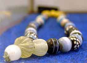
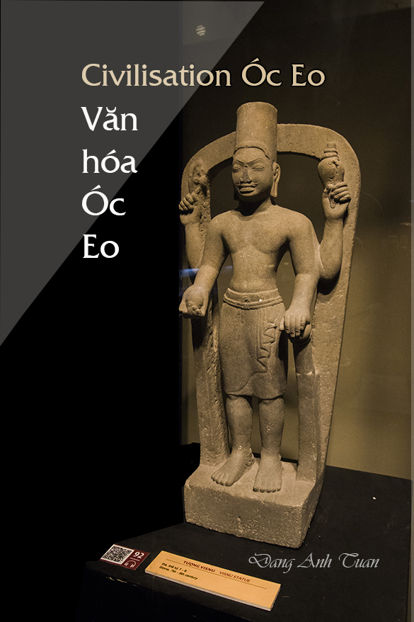
  • Thời kỳ thứ hai của lịch sử Phù Nam  (thế kỷ thứ 4 đến thế kỷ 7) được đánh dấu bằng việc phát hiện ra một số lượng lớn các di tích tôn giáo và Phật giáo Vishnu trên các gò của đồng bằng Óc Eo và trên các sườn núi Ba Thê. Các nhân vật biểu tượng của Ấn Độ ( như  thần Shiva, Vishnu, Brahma, Nanin, Ganesha và Đức Phật)  đã được khai quật. Đây cũng là thời kỳ mà các nhà sàn bằng gỗ  được dời đi từ các gò đến các vùng ngập nước và các sườn núi dốc thấp của núi Ba Thê.Việc Ấn Độ hóa vương quốc được diễn ra khi một người Ấn Độ tên là Chu Tchan-t’an viết theo chữ Hán, sống vào khoảng năm 357, có thể là người gốc Xi-tơ (scythe) và thậm chí cũng có thể là gốc Kanishka, trị vì ở vương quốc Phù  Nam [The Founan: Paul Pelliot, trang 269]. Có thể  đây là sự giải thích việc thành công của giáo phái Surya và biểu tượng của nó trong nghệ thuật của người dân Phù Nam. Một người Bà la môn khác tên Trung Hoa là Kiao-Tchen-Jou (hay còn gọi là Kawa-Jayavarma) được  kế vị sau đó và cai trị Phù Nam trong khoảng thời gian từ 478 đến 514. Đây là thời kỳ nổi tiếng nhờ có những văn khắc địa phương viết bằng tiếng Phạn. Ngay cả huyền thoại về việc thành lập vương quốc cũng được xuất phát từ Ấn Độ: Một người dũng sĩ Bà La môn tên là Kaundinya trong một giấc mơ có được một cây cung ma thuật trong một ngôi đền và  hướng dẫn thuyền đến các bờ biển mà anh ta thành công đánh bại một  người phụ nữ tên là Soma, con của một vị vua đang cai trị vùng bản địa được xem như là vua Naga (một con rắn tuyệt vời). Sau đó anh kết hôn với cô nầy để cai trị đất nước này. Có thể nói rằng trong thời kỳ này, vương quốc Phù Nam đã đạt đến đỉnh cao và duy trì mối quan hệ chặt chẽ với Trung Quốc.Sự phát triển thương mại của Phù Nam không thể chối cãi được khi phát hiện ra một số lượng lớn các vật thể không phải của Ấn Độ được tìm thấy ở trên bờ của Phù Nam: những mảnh gương bằng đồng có từ thời Tây Hán, các tượng phật bằng đồng được gán cho nhà Ngụy, một nhóm vật thể thuần túy La Mã, các bức tượng theo phong cách Hy Lạp, đặc biệt là một đại diện bằng đồng của  thần Poseidon. Những đồ vật này có lẽ đã được trao đổi để lấy hàng vì người dân Phù Nam chỉ biết mậu dịch đổi hàng. Để mua hàng hóa có giá trị, họ  sử dụng các thỏi vàng và bạc, ngọc trai và nước hoa. Họ được biết đến như những thợ kim hoàn xuất sắc. Vàng đã được gia công một cách  tinh xảo với nhiều biểu tượng Bà la môn. Những đồ nữ  trang (bông tai bằng vàng với cái móc  tinh tế, những sợi vàng đáng ngưỡng mộ,  các hạt thủy tinh, các đá màu chạm hình vân vân..) được trưng bày ở các bảo tàng của Đồng Tháp, Long An và An Giang chứng minh không những  bí quyết và tài năng của họ mà còn là sự ngưỡng mộ của người Trung Hoa qua những câu chuyện mà họ có dịp tiếp xúc với người dân Phù Nam.
  •  Thời kỳ cuối cùng tương ứng với sự suy tàn và sự kết thúc của vương quốc Phù Nam. Một thay đổi quan trọng đã được báo cáo trong thời kỳ Cheng-kuan (627-649) tại vương quốc Founan trong biên niên sử Trung Quốc. Vương quốc Chen-la (Chân Lạp) (Campuchia tương lai) nằm ở phía tây nam Lâm Ấp (Champa tương lai) và là quốc gia chư hầu của Phù Nam xâm chiếm và chinh phục  Phù Nam. Sự thật này đã được báo cáo không những trong lịch sử mới của nhà Đường (618-907) bởi nhà sử học Trung Hoa Ouyang Xiu, mà còn trên một bản khắc chưa được công bố của Sambor-Prei Kuk, trong đó nhà vua của Chân Lạp  Içanavarman  nhận được  sự chúc mừng vì ông đã thành công mở rộng lãnh thổ của bố mẹ ông. Các khu nhà ở và các nơi tôn giáo ở đồng bằng Óc Eo đang bị bỏ hoang vì sự hình thành chính trị mới đến từ phương Bắc đang di chuyển tách  rời bờ biển và tiếp cận dần dần địa điểm Angkor, thủ đô tương lai của Đế quốc Khơ Me. Đối với nhà nghiên cứu J. Népote, đến từ miền Bắc nước Lào xuất hiện dưới dạng các nhóm người Giéc Ma Ni với đế chế La Mã, nhóm người Khơ Me cố gắng tạo thành một vương quốc thống nhất ở nội địa với tên là Chân Lạp. Họ không thấy có lợi ích để giữ kỹ thuật trồng lúa nổi vì họ sống rất  xa bờ biển. Họ cố gắng phối hợp  những gì họ thông thạo hiểu biết trong cách giữ nước với sự  bổ sung thêm khoa học thủy lực của người Ấn Độ để phát triển  qua nhiều lần  thử nghiệm, một hệ thống thủy lợi thích hợp hơn với hệ sinh thái của vùng nội địa và các giống lúa địa phương. Mặc dù có những khám phá gần đây xác nhận sự tồn tại của vương quốc này, nhiều câu hỏi vẫn chưa được có  câu trả lời. Chúng ta không biết ai là người bản địa ở vương quốc này. Chúng ta chắc chắn một điều: họ không phải là người Việt Nam chỉ đến đồng bằng sông Cửu Long vào thế kỷ 17. Có phải họ là tổ tiên của người Khơ Me? Một số người tin chắc là vậy lúc thời điểm mà Louis Malleret bắt đầu khai quật vào những năm 40 bởi vì tên tuổi của khu vực hoàn toàn là tiếng Khơ Me. Vào thời Phù Nam, chúng ta vẫn chưa biết rõ họ là ai. Mặt khác, nhờ việc nghiên cứu về  các di tích xương ở bán đảo Cà Mau, chúng ta  tìm thấy được  một dân số rất gần gũi với người Nam Á. Sự đóng góp của người Môn Khmer ở ​​phía bắc của vương quốc này có thể nghĩ đến để  mang lại cho Phù Nam  sự kề nhau và hợp nhất của hai tầng lớp không xa nhau chi cho mấy  trước khi trở thành chủng tộc Phù Nam. Trong giả thuyết được chấp nhận thường xuyên này, người dân Phù Nam là tổ tiên hoặc là người anh em họ của người Khơ Me. Sự gia nhập một thành phố từ bán đảo Mã Lai (được gọi là Dunsun theo các nguồn báo cáo của Trung Quốc) trong một khu vực mà ảnh hưởng của người Môn-Khmer không thể phủ nhận được ở thế kỷ thứ ba bởi Phù Nam là một trong những yếu tố  chính dẫn đến sự ủng hộ giả thuyết này. Trong điều kiện nào Óc Eo bị biến mất? Tuy nhiên, Óc Eo đóng một vai trò kinh tế quan trọng trong việc trao đổi thương mại suốt bảy thế kỷ đầu tiên của kỷ nguyên Kitô giáo. Các nhà khảo cổ tiếp tục tìm kiếm nguyên nhân của sự biến mất của thành phố hải cảng này: lũ lụt, hỏa hoạn, đại hồng thủy, dịch bệnh vân vân… Vương quốc Phù Nam có phải là một quốc gia thống nhất với một quyền lực trung ương mạnh mẽ hay là một liên đoàn các trung tâm quyền lực chính trị được đô thị hóa và tự trị trên bán đảo Đông Dương như trên bán đảo Mã Lai  để được gọi là các quốc gia thành phố?  P.Y. Manguin đã nêu câu hỏi nầy tại một hội nghị chuyên đề do trung tâm Copenhagen Polis tổ chức tại các quốc gia ở ven biển Đông Nam Á vào tháng 12 năm 1998. Thủ đô của Phù Nam nằm  ở đâu nếu quyền lực trung ương được nhấn mạnh nhiều lần bởi người Trung Quốc trong văn bản của họ? Angkor Borei, Bà Phnom có ​​thực sự là thủ đô cổ của vương quốc này như đã được Georges Coèdes xác định? Cho đến nay, những gì đã được tìm thấy không cung cấp được câu trả lời mà  chỉ làm tăng thêm gấp đôi sự mong muốn và khao khát của các nhà khảo cổ để tìm thấy trong những năm tới bởi vì họ có cảm giác  có được một nền văn minh rực rỡ của đồng bằng sông Cửu Long.

Références bibliographiques

Georges Coedès: Quelques précisions sur la fin du Founan, BEFEO Tome 43, 1943, pp1-8
Bernard Philippe Groslier: Indochine, Editions Albin Michel, Paris 
Lê Xuân Diêm, Ðào Linh Côn,Võ Sĩ Khai: Văn Hoá Oc eo , những khám phá mới (La culture de Óc Eo: Quelques découvertes récentes) , Hànôi: Viện Khoa Học Xã Hội, Hô Chí Minh Ville,1995 
Manguin,P.Y: Les Cités-Etats de l’Asie du Sud-Est Côtière. De l’ancienneté et la permanence des formes urbaines. 
Nepote J., Guillaume X.: Vietnam, Guides Olizane 
Pierre Rossion: le delta du Mékong, berceau de l’art khmer, Archeologia, 2005, no422, pp. 56-65.


Funan kingdom (Vương quốc Phù Nam)

founan

French version

Funan kingdom

Until the dawn of the 20th century, the information was received about this old Hinduized kingdom in some Chinese texts. It was mentioned during the Three Warring States period of Chinese history (Tam Quốc )(220-265) in Chinese writings since the establisment of diplomatic relations between  the Wu state (Đông Ngô) and foreign countries. In this report, it is noted that the governor of Guandong and Tonkin provinces, Lu-Tai sent representatives (congshi) in the south of his kingdom. The kings, beyond the borders of his kingdom (Funan, LinYi (future Chămpa) and Tang Ming (country identified in the northern Tchenla at the time of Tang dynasty) sent each other an ambassador to pay him their tribute. Then Funan was also quoted in the dynastic annals from the Tsin dynasty (nhà Tấn) until the Tang dynasty (Nhà Ðường).

Even the name of Funan is the phonetic transcription of the old khmer word bhnam (mountain) in Chinese characters. It still gives rise to reservations and reluctances in the interpretation of Funan by « mountain » for some experts. These one find the justification of the name « Funan » in the best sense of « hillock » because, until quite recently, in the ethnographical studies [Martin 1991; Porée-Maspero 1962-69] , the Khmer were used to practising ceremonies around the artificial hillocks. Being affected by this custom that they did not know, the Chinese have made reference to this mode of practice for designating this kingdom. Thanks to archaeological excavations which took place in 1944 at Óc Eo with French Louis Malleret in An Giang province located into the south of present-day Vietnam, the existence and prosperity of this Indianised kingdom have not been in doubt. The results of these excavations had been written in his doctoral thesis, then published in an entitled work « Archaeology of the Mekong delta » representing 6 volumes.

© Đặng Anh Tuấn

This allows to confirm the Chinese informations and to make them a little more precise in the confinement and localization of this kingdom. Because of the abundance of  tin archaeological finds, French archaeologist Louis Malleret did not hesitate to borrow the name Óc Eo for designating this tin civilization. We begin to have now a deep light on this kingdom as well as its external relations during the resumption of excavations undertaken both by Vietnamese teams (Đào Linh Côn, Võ Sĩ Khải, Lê Xuân Diêm) and French-Vietnamese team led by Pierre-Yves Manguin between 1998 and 2002 in An Giang, Ðồng Tháp and Long An provinces where a large number of sites of Óc Eo culture are located.

We know that Óc Eo was a major port of this kingdom and was a transit hub in trade exhanges between the Malaysian peninsula and India on one hand and between the Mekong and China on other one. As the boats of the region could not cover long distances and had to follow the coast, Óc Eo thus became a mandatory stop and a important strategic step during the 7 centuries of blooming and prosperity for Funan kingdom.

Óc Eo civilization

Pictures gallery 

This one occupied a quadrangle included between the gulf of Thailand and Transbassac (western plains of Mekong delta or miền tây in Vietnamese) in the South of Vietnam. It was bounded in the northwest by the Cambodian border and in the southeast by Trà Vinh and Sóc Trăng cities. Aerial photos taken by the French people in the 1920s revealed that Funan was a maritime empire (or a thalassocracy).

The Chinese authors tell us that immense city states, encircled by successive lines of earthen ramparts and ditches formely filled by crocodiles, were divided into districts by the ramification of canals and arteries. We can imagine houses and stores on piles, bordered by ships as in Venice or in the Hanseatic cities. We discover in this surprising network constituted by stars of rectilinear canals arranged according to the northeast / southwest frame (from Bassac towards the sea) and all communicating with each other, its important role for evacuating Bassac floodwaters towards the sea. This allows to wash the soil with alum, repulse headways of brackish water during Bassac floods, favor the floating rice, ensure especially the provisioning inside the kingdom by cargoes of coastal navigation coming from China, Malaysia, India and even from Mediterranean circumference.

The discovery of gold coins bearing Antonin le Pieux (in 152 A.D.) or Marc Aurèle’s effigies and low-reliefs carvings of Persian kings testifies to the important role of this kingdom in trade exchanges at the beginning of the Christian era. There is even a grand canal allowing to connect the port city Óc Eo on one hand with the sea and on the other hand with the Mekong and the ancient city of Angkor Borei, located 90 km upstream in the Cambodian territory. This one would be presumably the capital of Funan in its decline.

For French archaeologist Georges Coedès, there is no question that the Angkor Borei site corresponds exactly to that of Na-fou-na, described in Chinese texts as the city where kings of Funan wildrew after their eviction from the ancient capital of Funan, Tö-mu, identified as the city Vyàdhapura located in the Bà Phnom region of the Cambodian territory by Georges Coedès [BEFEO, XXVIII, p. 127]. The wealth of this archeological site and the variety of archeological remains originating from it, confirm his affirmation.

Thanks to archeological finds that have been recovered during all series of excavations on the complex of Óc Eo sites, we can say that this kingdom knew three important periods during its existence:

The first period which extends from the 1st to about 3th century, distinguishes itself by terra-cottas (ceramic potteries, bricks, tiles), glassware (pearls and necklaces), silverware (rings, earrings), stones sculptures (seals, signet rings, cabochons), copper, iron, bronze and especially tin objects.

We attend the first human activity on hillocks in the Óc Eo plain and on low slopes of Ba Thê mountain. The habitat is on piles and wood. The common jar grave in the South-East Asia is still practised. The process of the Indianisation is not yet started by the absence of statuaries and religious relics. But there is, all the same, a regular contact between this kingdom and India.

The commercial exchange is strengthened by local alliances and Indian teachers arrival. These one, retained longer for their stays in this kingdom because of the season of monsoons, continued to practise their religions (Brahmanism, Buddhism). They began to make emulators among the natives and to help the latter in the implementation of a hydraulic network allowing to drain the flooded plain, until now, hostile and to make it « useful » for the habitat, cultivation and development of their kingdom. The Indians were known to realize advisedly the works of agricultural hydraulics and cultivation. It is what we have seen in the country of the Tamils during the Pallava period for example.

The floating rice cultivation is attested by the traces of use of this graminaceous plant as degreasing agent for pottery. For French researcher of CNRS, J.N. Népote, specialist of the Indo-Chinese peninsula, Funan kingdom received most of its revenues from the agricultural sector in the technique of floating rice.

It was not necessary to cultivate the soil nor to sow and even less to plant rice seedlings in this time when the coastal fringe of Funan was an flooded zone of polders. The rice grew alone at the same time as the water level, this one being able to reach three metres in height. The rice was later harvested by boats. For the floating rice, the only constraint to be required was the distribution and regulation of floods by the digging of canals in order to be better able to manage the irrigation water and facilitate the means of communication.

The second period of the Funan history (4th- 7th centuries) is marked by the discovery of a large number of Vishnouist and Buddhist religious monuments on the hillocks of Oc Eo plain and on the slopes of Mount Ba Thê. The emblematic figures of the Indian pantheon (Shiva, Vishnu, Brahma, Nanin, Ganesha and Buddha) were exposed. It is also the period when the piled wooden housing moves from hillocks towards flooded plain and low slopes of Ba Thê mountain.

The indianisation of the kingdom was underway when we saw around 357 an Indian of Chinese name Tchou Tchan-t’an, being perhaps of Scythian origin and Kanishka descent, to reign in Funan kingdom [Founan: Paul Pelliot, p 269], which could explain the success of the Surya cult and its iconography in the Funan art. Another Brahman of Chinese name (Kiao-Tchen-Jou) (or Kaundinga-Jayavarma) will succeed him and will reign in Funan kingdom between 478 and 514. It is the period quite known thanks to local inscriptions in sanskrit.

Even the myth of the kingdom’s foundation comes from India: a Brahman named Kaundinya, guided by a dream, get a magic bow in a temple and navigates towards these banks where he manages to beat the girl named Soma of the native sovereign presented as Naga king (a fabulous snake) then he marries her to govern this country. We can say that during this period, the Funan kingdom knew its peak and maintained close relations with China.

The magnitude of its trade was indisputable by the discovery of a large number of objects other than that of India found on Funan banks: fragments of bronze mirrors dating from the Han anterior period, Buddhist bronze statuettes attributed to Wei dynasty, a group of purely Roman objects, statuettes of Hellenistic style in particular a bronze representation of Poseidon. These objects were probably exchanged for goods because Funan people only knew the barter. For the purchase of valuable products, they used golden and silver ingots, pearls and perfumes. They were known as excellent jewelers. The gold was finely worked with numerous Brahmanic symbols. Jewels (golden earrings with the delicate clasp, admirable golden filigrees, glass pearls, intaglios etc.) exposed in the museums of Đồng Tháp, Long An and An Giang testifies not only of their know-how and their talent but also the admiration of the Chinese in their narratives during their contact with Funan people.

The last period corresponds to the decline and end of Funan kingdom. A important change was indicated during period tcheng-kouan (627-649) to Funan kingdom in the Chinese annals. The kingdom of Tchen-la (Chân Lập) (future Cambodia) situated in the southwest of Lin Yi ( uture Champa) and country vassal of Funan took over the latter and subjugated it. This fact was not only reported in the new history of Tang (618-907) of Chinese historian Ouyang Xiu but also on a new inscription of Sambor-Prei Kuk in which king of Tchen La, Içanavarman was congratulated for having increased the territory of his parents. One thus bear witness to the abandonment of habitat and religious sites in the plain Óc Eo because the centre of gravity of the new political formation coming from the North leaves the coast to gradually approach the site of the future capital of Khmer empire, Angkor.

For French researcher J. Népote, the Khmers come from the North by Laos appear as Germanic bands against the Roman empire, try to establish inside lands a unitarian kingdom under the name of Chen La. They have no interest to keep the technique of the floating rice because they live far from the coast. They try to combine their own mastery of water storage with the contributions of Indian hydraulic science (barays) to finalize through multiple experimentations an irrigation better adjusted to the hinterland ecology and local varieties of irrigated rice.

In spite of the recent discoveries confirming the existence of this kingdom, many questions have remained unanswered. We do not know who were the indigenous people populating this kingdom. One thing is for sure: they were not Vietnamese who had arrived only in the Mekong delta in the 17th century. Were they ancestors of the Khmers? Some had this conviction when Louis Malleret began excavations in the 1940s because the toponymy of the region was totally Khmer. At the time of Funan, it was yet not clear what this is. However, thanks to the study of osseous remains of Cent-Rues (in the peninsula of Cà Mau), we are dealing with a population very close to Indonesians (or Austro-Asiatic ) (Nam Á).

A Mon-Khmer contribution in the North of this kingdom can be possible to give to Funan the juxtaposition and the fusion of two strata which are not far away from each other before becoming the race of Funan people. In this hypothesis frequently accepted, the Funan people were the proto-Khmers or the cousins of the Khmers. The absorption of a city of Malaysian peninsula (known under the name Dunsun in the Chinese sources reporting this fact ) in the 3th century by Funan in an area where the Mon-Khmer influence is undeniable, is one of the determining elements in favour of this hypothesis.

In what conditions did Óc Eo disappear? Nevertheless Óc Eo played an economic role in commercial exchanges during seven first ones centuries of the Christian era. The archaeologists continue to look for the causes of the disappearance of this port city: flood, fire, deluge, epidemic etc. …

Is the Funan kingdom a state unified with a strong central power or is it a federation of centers of urbanized and sufficiently autonomous political power on the Indo-Chinese peninsula as on the Malaysian peninsula so that we qualify them as city-states?

P.Y.Manguin has already raised this question during a colloquium organized by Copenhagen Polis centers on the city-states of the coastal South-East Asia in December, 1998. Where is its capital if the central power is strongly emphasized many times by the Chinese in their texts? Angkor Borei, Bà Phnom are they really the former capitals of this kingdom like that has been identified by French Georges Coèdes? For the moment, what has been found does not bring answers but it only redoubles the envy and desire of archaeologists to find them in the coming years because they know that they have the feeling of dealing with brilliant civilization of the Mekong delta.


Bibliography references

Georges Coedès: Quelques précisions sur la fin du Founan, BEFEO Tome 43, 1943, pp1-8
Bernard Philippe Groslier: Indochine, Editions Albin Michel, Paris 
Lê Xuân Diêm, Ðào Linh Côn,Võ Sĩ Khai: Văn Hoá Oc eo , những khám phá mới (La culture de Óc Eo: Quelques découvertes récentes) , Hànôi: Viện Khoa Học Xã Hội, Hô Chí Minh Ville,1995 
Manguin,P.Y: Les Cités-Etats de l’Asie du Sud-Est Côtière. De l’ancienneté et la permanence des formes urbaines. 
Nepote J., Guillaume X.: Vietnam, Guides Olizane 
Pierre Rossion: le delta du Mékong, berceau de l’art khmer, Archeologia, 2005, no422, pp. 56-65.

Mekong delta river (Đồng Bằng Cửu Long)

 Version française


Cửu Long nơi có chín rồng
Có sông nhiều cá có đồng lúa xanh
Thưở xưa là đất tranh giành
Người Nam nhắc đến không đành lìa xa

The Mekong delta is the former territory of the kingdom Founan (Phù Nam). The Mekong delta’s natives are  the mixing of several Vietnamese, Khmer, Cham and Chinese peoples. A fifth of the population lives in this delta. The least hectare, the least cultivable parcel of the delta are exploited by peasants consisted of Vietnamese of Khmer origin, Chinese,Chàm, and Vietnamese. That is why a multitude of religions is found there: Buddhism, Catholicism, Caodaism, Islam, and Hoà Hảo. Irrigated and sprinkled by the Mekong River, this delta produced itself alone one-half of the rice of the country, which allows Vietnam to become the third largest exporter of rice in the world.

The Mekong delta is currently divided into  12 provinces: Long An, Tiền Giang, Bến Tre, Ðồng Tháp, An Giang, Kiên Giang,  Vĩnh Long, Trà Vinh, Hậu Giang, Sóc Trăng, Bạc Liêu  and Cà Mau.

Đồng Bằng Cửu Long

Before becoming an integral part of Vietnam, this delta belonged to the Khmer people. The first Vietnamese colonists appeared only at the beginning of the 16th century on this territory that was until then just a marshy area infested with crocodiles and filled with mangroves. It is only in 17th century that this territory became Vietnamese under the scepter of the lords Nguyễn. It was also the arena of violent clashes between the Tay Son’s armies and the Nguyen’s partisans supported by the mercenaries recruited by Pigneau de Béhaine at the end of 18th century.

One finds in this delta a labyrinth of channels and rivers that add up to 4,000 kilometers, which is equivalent to the length of the Mekong river itself. This river is born out of the snows from Tibet in the province of Qing Hai, flows for more than 4,500 km before reaching the delta and crosses six countries: China, Burma, Thailand, Laos, Kampuchea, and Vietnam. It divides itself at the capital of Kampuchea, Phnom-Penh into two branches, Mekong and Bassac that enter Vietnam separately. In Vietnam, its upper course is divided into four arms at Vĩnh Long to throw itself into the East Sea. (Biển Đông).

The great lake Tonlé Sap, located at the center of Kampuchea is not only a natural fish tank but also a natural regulator of the water flow making it possible to prevent the flood of the delta. In summer, because of monsoon rain, the level of Mekong is higher compared to that of the lake to which it is connected by a channel. The lake fills itself, passing from 3,000 square kilometers in season of low waters to more than 10,000 square kilometers at the end of the monsoon. The lake begins to reverse its water into the delta by the time the rain ends. The Mekong delta does not need big water management works or dikes to protect itself from swelling, which proves to be essential for the delta of the North. Thanks to the irrigation of Mekong, the delta is so fertile. Gardens, fields, rice plantations and orchards are seen everywhere.

These orchards are in fact small plots of land irrigated by channels connected to each other by bamboo bridges often called Cầu Khỉ (Monkey Bridges). When referring to the delta, the term « cò bay thẳng cánh«  is often used. This means the delta is so vast that the cranes can extend their wings as they fly over. 

It is in this delta, at Sadec, that Marguerite Duras‘ mother ran the girls’ school. A young Chinese of good family lived there too. He will become the hero in « The Lover « . This novel has made Marguerite Duras a superstar of the French literature overnight allowing her to win the Prix de Goncourt in 1984 and ensure the sale of one million three hundred thousand copies in paperback in Midnight Editions and one million copies in hardcover at France-Loisirs.

It is also in this delta that are seen every morning, hundreds of sampans converging toward the famous floating market of Phùng Hiêp at the crossroad of seven channels in the direction of Cần Thơ to Sóc Trăng, or toward lesser known markets such as Cái Răng and Phong Ðiền. Also seen are merchants with conic hats trailing their mountains of fruits, legions of ducks, chickens and pigs to the market on their small boats, or other rudimentary means of transportation (bicycles, rickshaws). It is thanks to the orchards of the delta that one finds a great number of fruits: sapotilles, ramboutans, caramboles, corrosoles etc… at the markets of Saigon. It can be said that the delta feeds Saigon and a greater part of Vietnam. In the northeast of the peninsula lies the Plain of Reed Ðồng Tháp Mười ) which was a Việt Cộng refuge yesterday and which becomes the Asian Camargue today.

In spite of its lack of archaeological richness, the delta continues to play a vital role economically for Vietnam. It becomes thus the object of greed and confrontation for so many years. It was French Cochinchina at one recent time. Even Hồ Chí Minh, when alive, has agreed to its importance by burying his father at Sadec. There are folks whose names remain anchored in the memory of the Vietnamese people. Phan Thanh GiảnVõ TánhNguyễn Trung TrựcHùynh Phú Sổ, are among these folks and are issue of this corner.


Without the delta, Vietnam is never free and independent….. 
It is the granary of Vietnam.


Ta Prohm (Temple-monastery)

French version

                                                                                                  Great king Jayavarman VII

taprohm

Unlike most of the temples of Angkor, Ta Prohm was left in a state of ruin. It was deliberately chosen by the École française d’Extrême-Orient (French School of Oriental Studies) as an example of what the temples of Angkor looked like at the time of their discovery in the XIXth century. For building this temple, the sovereign Jayavarman VII relied upon the income which the rice culture gave him. The money did not exist at that time. The currency of exchange remained the rice, the basic food of the workers enlisted to build the temple. We find in the Ta Prohm site an inscription indicating that 12 640 people served in this single temple.

It also reports that more than 66 000 farmers produced more than 2 500 tons of rice a year to feed the multitude of priests, dancers and workers in the temple. Because of its romantic attraction, the Ta Prohm temple was selected in the American movie Tomb Raider with Lara Croft (Angela Joli).

Đền – Tu viện Ta Prohm


It is here that the nature took back her rights. Certain walls of the Ta Prohm site can only stand up thanks to the roots of fig and cheese trees who enclose them as huge octopuses. Ta Prohm is considered as one of the temples the most appreciated in Angkor. It was built by great king builder Jaravarman VII at the end of the XIIth century. It was dedicated to his mother because we find the surprising resemblance of this one in the statue of the main divinity in this temple, Prajnaparamita (Perfection of the wisdom). His father was not either forgotten because Lokeçvara, the main god of Preah Khan looks like him enormously.

Ta Prohm (Temple-Monastère)

                                                                                                  Le grand roi Jayavarman VII

taprohm

A la différence de la plupart des temples d’Angkor, Ta Prohm a été laissé dans un état de ruine. Il a été choisi délibérément par l’École française d’Extrême-Orient comme un exemple de ce à quoi les temples d’Angkor ressemblaient au moment de leur découverte au XIXè siècle. Pour construire ce temple, le souverain Jayavarman VII comptait sur les revenus que lui procurait la culture du riz. L’argent n’existait pas à cette époque. La monnaie d’échange restait le riz, aliment de base des ouvriers enrôlés pour bâtir le temple. On trouve sur le site Ta Prohm une inscription indiquant que 12 640 personnes servaient dans ce seul temple.

Elle rapporte aussi que plus de 66 000 fermiers produisaient plus de 2 500 tonnes de riz par an pour nourrir la multitude de prêtres, de danseuses et d’ouvriers du temple. A cause de son attrait romantique, le temple Ta Prohm a été sélectionné dans le film américain Tomb Raider avec Lara Croft (Angela Joli).

 Ta Prohm (Đền tu viện)

C’est ici que la nature reprend ses droits. Certains murs du site Ta Prohm ne peuvent tenir debout que grâce aux racines des figuiers et des fromagers qui les enserrent comme des poulpes géants. Ta Prohm est considéré comme l’un des temples les plus prisés d’Angkor. Il fut construit par le grand roi bâtisseur Jaravarman VII à la fin du XIIè siècle. Il fut dédié à sa mère car on trouve la ressemblance étonnante de celle-ci dans la statue de la divinité principale de ce temple, Prajnaparamita (Perfection de la sagesse). Son père n’était pas oublié non plus car Lokeçvara, le dieu principal de Preah Khan lui ressemble énormément.

Royaume du Founan (Vương quốc Phù Nam)

founan

English version

Vietnamese version

Jusqu’à l’aube du XXème siècle, on fut renseigné seulement  sur cet ancien royaume hindouisé  dans quelques écrits chinois. Il fut mentionné d’abord à l’époque des Trois Royaumes Combattants (220-265) dans un texte chinois lors de l’établissement des relations diplomatiques des Wu (Đông Ngô en vietnamien ) avec les pays étrangers. Dans ce rapport, on nota que le gouverneur du Guandong et du Tonkin, Lu-Tai envoya des représentants (congshi) au sud de son royaume. Les rois au-delà des frontières de son royaume (Founan, LinYi (futur Champa) et Tang Ming (pays identifié au nord du Tchenla à l’époque des Tang)) envoyèrent chacun un ambassadeur pour lui payer un tribut. Puis Founan était cité aussi dans les annales dynastiques des Tsin (nhà Tấn) jusqu’aux Tang (Nhà Đường).

De même, le nom du Founan est la transcription phonétique de l’ancien mot khmer bhnam (montagne) en caractères chinois. Cela suscite quand même des réserves et des réticences dans l’interprétation du mot « Founan » par « montagne » pour certains spécialistes. Ceux-ci trouvent mieux la justification du mot Founan dans le sens de « tertre » car jusqu’à une époque récente, dans les études ethnographiques [Martin 1991 ; Porée-Maspero 1962-69] les Khmers avaient l’habitude de pratiquer des cérémonies autour des tertres artificiels. Les Chinois frappés par cette coutume qu’ils ne connaissaient pas ont fait allusion à ce mode de pratique pour désigner ce royaume. C’est grâce aux fouilles archéologiques entamées par Louis Malleret en 1944 à Oc eo dans la province An Giang du sud du Vietnam actuel, que l’existence et la prospérité de ce royaume indianisé» ne furent plus mises en doute. Les résultats de ces fouilles étaient apparus dans sa thèse de doctorat, puis publiés dans un ouvrage intitulé « Archéologie du delta du Mékong » et composé de 6 tomes.

Cela permet de corroborer les données chinoises et de les rendre un peu plus précises dans le confinement et la localisation de ce royaume. En raison de l’abondance des trouvailles archéologiques en étain, l’archéologue français Louis Malleret n’hésitait pas à emprunter le nom Óc Eo pour désigner cette civilisation de l’étain. On commence à avoir désormais une vive lumière sur ce royaume ainsi que sur ses relations extérieures lors de la reprise des campagnes de fouilles menées tant par des équipes vietnamiennes( Đào Linh Côn, Võ Sĩ Khải, Lê Xuân Diêm ) que par l’équipe franco-vietnamienne dirigée par Pierre-Yves Manguin entre 1998 et 2002 dans les provinces An Giang, Đồng Tháp et Long An où se trouve un grand nombre de sites de culture Óc Eo. On sait que Óc Eo était un grand port de ce royaume et une plaque tournante dans les échanges commerciaux entre la péninsule malaisienne et l’Inde d’une part et entre le Mékong et la Chine d’autre part. Comme les bateaux de la région ne pouvaient pas couvrir de longues distances et devaient suivre la côte, Óc Eo devint ainsi un passage obligatoire et une étape stratégique durant les 7 siècles de floraison et de prospérité du royaume du Founan. Celui-ci occupait un quadrilatère compris entre le golfe de Thailande et le Transbassac (plaines occidentales du delta du Mékong ou miền tây en vietnamien) dans le sud du Vietnam. Il était délimité au nord-ouest par la frontière cambodgienne et au sud-est par les villes de Trà Vinh et de Sóc Trăng. Des photos aériennes prises par les Français dans les années 1920 révélaient que Founan était un empire maritime (ou une thalassocratie).

Ceinturées par des lignes successives de remparts de terre et de fossés remplis jadis par des crocodiles, d’immenses cités états étaient divisées en quartiers par la ramification des canaux et des artères, nous disaient les auteurs chinois. On peut imaginer les maisons et les magasins sur pilotis bordés de navires comme à Venise ou dans les villes hanséatiques. On découvre dans cet étonnant réseau constitué par les étoiles de canaux rectilignes disposées selon la trame nord-est/sud-ouest (du Bassac vers la mer) et communiquant toutes les unes avec les autres, le rôle important d’évacuation des crues de Bassac vers la mer, ce qui permet de laver les sols alunés, refouler les avancées des eaux saumâtres lors des crues du Bassac, favoriser la culture du riz flottant et assurer surtout le ravitaillement par l’acheminent, à l’intérieur du royaume, des cargaisons de cabotage venant de Chine, de Malaisie, de l’Inde et même du pourtour méditerranéen. La découverte des monnaies d’or à l’effigie d’Antonin le Pieux, datant de 152 ap. J.C. ou de Marc Aurèle  et des bas-reliefs des rois perses témoigne du rôle important de ce royaume dans les échanges commerciaux au début de l’ère chrétienne. Il y a même un grand canal permettant de relier sa ville portuaire Óc Eo d’une part à la mer et d’autre part au Mékong et à la ville ancienne d’Angkor Borei située à 90 km en amont dans le territoire cambodgien. Celle-ci serait vraisemblablement la capitale du Founan à son déclin.

Pour l’archéologue français Georges Coedès, il ne fait aucun doute que l’emplacement d’Angkor Borei correspond exactement à celui de Na-fou-na, décrit dans les textes chinois comme la ville où se retirèrent les rois fouanais après leur éviction de l’ancienne capitale du Founan, Tö-mu, identifiée comme la ville Vyàdhapura et localisée dans la région de Bà Phnom du territoire cambodgien par Georges Coedès [BEFEO, XXVIII, p.127]. La richesse de ce site archéologique et la variété des vestiges archéologiques qui en proviennent corroborent son affirmation.

Grâce à des objets mis au jour lors de toutes les campagnes de fouilles sur le complexe de sites de Óc Eo, on peut dire que ce royaume connut trois périodes importantes durant son existence :
La première période qui s’étend du Ier au III ème siècle environ se distingue par des terres cuites (poteries en céramique, briques, tuiles), la verrerie (perles et colliers), l’orfèvrerie en or (bagues, boucles d’oreilles), des pierres gravées (sceaux, bagues à chaton, cabochons), d’objets en cuivre, fer, bronze et surtout en étain. 

On assiste à la première occupation humaine sur des tertres dans la plaine de Óc Eo et sur les basses pentes du mont Ba Thê. L’habitat est sur pilotis et en bois. La sépulture en jarre, fréquente dans l’Asie du Sud est pratiquée encore. Le processus de l’indianisation n’est pas encore entamé par l’absence de statuaires et de reliques religieuses. Mais il y a quand même un contact régulier entre ce royaume et l’Inde.

L’échange commercial est renforcé par des alliances locales et l’arrivée des maîtres indiens. Ceux-ci, retenus plus longtemps pour leurs séjours dans ce royaume à cause de la saison des moussons, continuaient à pratiquer leurs religions (brahmanisme, bouddhisme). Ils commençaient à faire des émules parmi les indigènes et à aider ces derniers dans la mise en place d’un réseau hydraulique permettant de drainer la plaine jusqu’alors hostile et inondée et de la rendre « utile » pour l’habitat, la culture et l’aménagement de leur royaume. Les Indiens étaient connus pour réaliser à bon escient les travaux d’hydraulique agricole et de mise en culture. C’est ce qu’on a vu dans le pays tamoul sous les Pallava par exemple.

La culture du riz flottant est attestée par les traces d’utilisation de cette graminacée comme agent dégraissant pour les poteries. Pour le chercheur du CNRS J.Népote, spécialiste de la péninsule indochinoise, le royaume du Founan tirait l’essentiel de ses ressources agraires dans la technique du riz flottant.

Il n’était pas nécessaire de cultiver la terre ni de l’ensemencer et encore moins de repiquer les plants de riz à cette époque du fait que la frange côtière du Founan était une zone de polders inondable. Le riz poussait tout seul en même temps que le niveau de l’eau, celui-ci pouvant atteindre trois mètres de hauteur. Le riz était ensuite récolté par les barques. Pour la culture du riz flottant, la seule contrainte exigée était la diffusion et la régulation des inondations par le creusement des canaux afin de pouvoir mieux gérer l’eau d’irrigation et faciliter les moyens de communication.

Art du Fou-nan VIème siècle après J.C. 

Terre cuite, polychromie moderne

phunam_3

La deuxième période de l’histoire du Founan (IVème –VIIème siècles) est marquée par la découverte d’un grand nombre de monuments religieux vishnouites et bouddhiques sur les tertres de la plaine Oc Eo et sur les flancs du mont Ba Thê. Les figures emblématiques du panthéon indien (Shiva, Vishnu, Brahma, Nanin, Ganesha et Bouddha) ont été mises au jour. C’est aussi la période où l’habitat en bois sur pilotis se déplace des tertres vers la plaine inondable et vers les basses pentes du mont Ba Thê.

L’indianisation du royaume était en marche lorsqu’on vit vers 357, un Indien de nom chinois Tchou Tchan-t’an, peut être d’origine scythe et de souche même de Kanishka, régner au royaume du Founan [ Le Founan : Paul Pelliot, p 269], ce qui pourrait expliquer le succès du culte de Surya et de son iconographie dans l’art fouannais. Un autre brahmane de nom chinois (Kiao-Tchen-Jou) (ou Kaundinga-Jayavarma) lui succédera et régnera sur le Founan entre 478 et 514. C’est la période assez connue grâce à des inscriptions locales en sanskrit.

Même le mythe de la fondation du royaume vient des Indes: Un brahmane du nom de Kaundinya guidé par un songe procure un arc magique dans un temple et navigue vers ces rives où il réussit de battre la fille de nom Soma du souverain indigène présenté comme le roi naga (un serpent fabuleux) puis il l’épouse pour gouverner ce pays. On peut dire que durant cette période, le royaume du Founan connut son apogée et entretint des relations suivies avec la Chine.

L’ampleur de son commerce fut incontestable par la découverte d’un grand nombre d’objets autres qu’indiens trouvés sur les rives du Founan: fragments de miroirs en bronze datant de l’époque des Han antérieurs, statuettes bouddhiques en bronze attribuées aux Wei, un groupe d’objets purement romains, des statuettes de style hellénistique en particulier une représentation en bronze de Poséidon. Ces objets étaient échangés probablement contre des marchandises car les Founanais ne connaissaient que le troc. Pour l’achat des produits de valeur, ils se servaient des lingots d’or et d’argent, des perles et des parfums. Ils étaient connus comme d’excellents bijoutiers. L’or était finement travaillé avec de nombreux symboles brahmaniques. Les bijoux (boucles d’oreilles en or au fermoir délicat, admirables filigranes d’or, perles de verre, intailles etc… ) exposés dans les musées de Đồng Tháp, Long An et An Giang témoignent non seulement de leur savoir-faire et de leur talent mais aussi de l’admiration des Chinois dans leurs récits durant leur contact avec les Founanais.

La dernière période correspond à la décadence et à la fin du royaume du Founan. Un important changement a été signalé durant la période tcheng-kouan (627-649) au royaume du Founan dans les annales chinoises. Le royaume de Tchen-la (Chân Lạp)( futur Cambodge) situé au sud-ouest du Lin Yi ( futur Champa) et pays vassal de Founan s’empara de ce dernier et le soumit. Ce fait a été rapporté non seulement dans la nouvelle histoire des Tang (618-907) de l’historien chinois Ouyang Xiu mais aussi sur une inscription inédite de Sambor-Prei Kuk dans laquelle on félicita le roi du Tchen La Içanavarman d’avoir grandi le territoire de ses parents. On assiste alors à l’abandon des sites d’habitat et religieux de la plaine Óc Eo car le centre de gravité de la nouvelle formation politique venant du Nord s’éloigne de la côte pour s’approcher progressivement du site de la future capitale de l’empire khmer, Angkor. Pour le chercheur J. Népote, les Khmers venus du Nord par le Laos apparaissent comme des bandes germaniques vis-à-vis de l’empire romain, tentent de constituer à l’intérieur des terres un royaume unitaire connu sous le nom de Chen La. Ils ne trouvent aucun intérêt de garder la technique de la culture du riz flottant car ils vivent loin de la côte. Ils tentent de combiner leur propre maîtrise des retenues d’eau avec les apports de science hydraulique indienne (les barays) pour mettre au point à travers de multiples tâtonnements une irrigation mieux adaptée à l’écologie de l’arrière- pays et aux variétés locales du riz irrigué. 

founan_collier

Collier en perles de verre de la culture Óc Eo.

Malgré les découvertes récentes confirmant l’existence de ce royaume, de nombreuses questions sont restées sans réponse. On ne sait pas qui étaient les populations autochtones peuplant ce royaume. On est sûr d’une seule chose: ils n’étaient pas des Vietnamiens arrivés seulement dans le delta du Mékong au XVIIème siècle. Étaient-ils des ancêtres des Khmers ? Certains ont eu cette conviction à l’époque où Louis Malleret entama des fouilles dans les années 40 car la toponymie de la région était totalement khmère. Au temps de Founan, on ne savait pas encore très bien qui ils sont. Par contre grâce à l’étude des vestiges osseux des Cent-Rues (dans la presqu’île de Cà Mau), on a affaire à une population très proche des Indonésiens (ou Austro-asiatiques) (Nam Á).

Un apport môn-khmer dans le nord de ce royaume peut être envisageable pour donner à Founan la juxtaposition et la fusion de deux strates qui ne sont guère éloignées l’une de l’autre avant de devenir la race founanaise. Dans cette hypothèse fréquemment admise, les Founanais étaient les proto-Khmers ou les cousins des Khmers. L’absorption d’une cité de la péninsule Malaise (connue sous le nom Dunsun dans les sources chinoises qui rapportent ce fait) au IIIème siècle par Founan dans une zone où l’influence môn-khmère est indéniable, est l’un des éléments déterminants en faveur de cette hypothèse.

Dans quelles conditions Óc Eo a-t-elle disparue ? Pourtant Óc Eo joua un rôle économique important dans les échanges commerciaux durant les sept premiers siècles de l’ère chrétienne. Les archéologues continuent à rechercher les causes de la disparition de cette ville portuaire: inondation, incendie, déluge, épidémie etc…

Galerie des photos de la civilisation Óc Eo


Le royaume du Founan est–il un état unifié avec un pouvoir central fort ou est-il une fédération de centres de pouvoir politique urbanisés et suffisamment autonomes sur la péninsule indochinoise comme sur la péninsule malaise pour qu’on les qualifie de cités-états ?

P.Y.Manguin a déjà soulevé cette question lors d’un colloque organisé par le Copenhagen Polis centre sur les cités-états de l’Asie du Sud-Est côtière en décembre 1998. Où est sa capitale si le pouvoir central est fortement souligné maintes fois par les Chinois dans leurs textes? Angkor Borei, Bà Phnom sont –elles vraiment les anciennes capitales de ce royaume comme cela a été identifié par Georges Coèdes ? Pour le moment, ce qui a été trouvé n’apporte pas des réponses mais cela fait redoubler seulement l’envie et le désir des archéologues de les trouver dans les années à venir car ils ont le sentiment d’avoir affaire à une brillante civilisation du delta du Mékong.


Références bibliographiques

Georges Coedès: Quelques précisions sur la fin du Founan, BEFEO Tome 43, 1943, pp1-8
Bernard Philippe Groslier: Indochine, Editions Albin Michel, Paris 
Lê Xuân Diêm, Ðào Linh Côn,Võ Sĩ Khai: Văn Hoá Oc eo , những khám phá mới (La culture de Óc Eo: Quelques découvertes récentes) , Hànôi: Viện Khoa Học Xã Hội, Hô Chí Minh Ville,1995 
Manguin,P.Y: Les Cités-Etats de l’Asie du Sud-Est Côtière. De l’ancienneté et la permanence des formes urbaines. 
Nepote J., Guillaume X.: Vietnam, Guides Olizane 
Pierre Rossion: le delta du Mékong, berceau de l’art khmer, Archeologia, 2005, no422, pp. 56-65.

Civilisation Óc Eo (Versions française, anglaise et vietnamienne)

poster_oc_eo

Version vietnamienne

English version

En raison de l’abondance des trouvailles archéologiques en étain à Óc Eo dans le delta du Mékong (An Giang), l’archéologue français Louis Malleret n’hésite pas à emprunter le nom Óc Eo pour désigner cette civilisation de l’étain. On commence à avoir désormais une vive lumière sur le royaume du Founan ainsi que sur ses relations extérieures lors de la reprise des campagnes de fouilles menées tant par des équipes vietnamiennes( Đào Linh Côn, Võ Sĩ Khải , Lê Xuân Diêm) que par l’équipe franco-vietnamienne dirigée par Pierre-Yves Manguin entre 1998 et 2002 dans les provinces An Giang, Đồng Tháp et Long An où se trouve un grand nombre de sites de culture Óc Eo. On sait que Óc Eo était un grand port de ce royaume et une plaque tournante dans les échanges commerciaux entre la péninsule malaisienne et l’Inde d’un côté et le Mékong et la Chine de l’autre. Comme les bateaux de la région  pouvaient  couvrir de longues distances et devaient suivre la côte, Óc Eo devint ainsi un passage obligatoire  et une étape stratégique importante   durant les 7 siècles de floraison et de prospérité du royaume du Founan.


Bảo tàng lịch sử Hà Nội

Cette civilisation de l’étain se distingue non seulement par sa culture du riz flottant mais aussi par son commerce avec l’extérieur. On a découvert un grand nombre d’objets autres que ceux de l’Inde trouvés  sur les rives du Founan: fragments de miroirs en bronze datant de l’époque des Han antérieurs, statuettes bouddhiques en bronze attribuées aux Wei, un groupe d’objets purement romains, des statuettes de style hellénistique en particulier une représentation de Poséidon en bronze. Ces objets étaient échangés probablement contre des marchandises car les Founanais ne connaissaient que le troc. Pour l’achat des produits de valeur, ils se servaient des lingots d’or et d’argent, des perles et des parfums. Ils étaient connus comme d’excellents bijoutiers. L’or était finement travaillé avec de nombreux symboles brahmaniques (Vishnu, Nandin, Vahara, Garuda, Shesha, Kurma etc…). Les bijoux (boucles d’oreilles en or au fermoir délicat,  filigranes d’or admirables, perles de verre, intailles etc… ) exposés dans les musées de Đồng Tháp, Long An et An Giang témoignent non seulement de leur savoir-faire et de leur talent mais aussi de l’admiration des Chinois dans leurs récits durant leur contact avec les Founanais. 

Version vietnamienne

Galerie des photos

Bảo tàng lịch sử Saigon

Văn Hóa Óc Eo

Au Musée  national de l’histoire (Saïgon) 

Vì lý do tìm ra được nhiều  các di vật cổ bằng thiếc  ở Óc Eo vùng châu thổ  sông  Cửu Long (An Giang),  nhà khảo cổ học Pháp Louis Malleret không ngần ngại mượn tên Óc Eo để chỉ định nền « văn hóa đồ thiếc ».  Chúng ta mới bất đầu từ đó  có cái nhìn sáng tỏ  về vương quốc Phù Nam  và các mối quan hệ bên ngoài  trong các  chiến dịch khai quật  kế tiếp lại  sau nầy với sự điều khiển  của nhóm người  Việt (Đào Linh Côn, Võ Sĩ Khải, Lê Xuân Diêm) và  nhóm người Việt  Pháp do ông Pierre-Yves Manguin đảm nhận giữa năm 1998 và 2002 ở An Giang, Đồng Tháp và Long An, các nơi mà có nhiều hiện vật của nền văn hóa Óc Eo. Chúng ta biết rằng Óc Eo là một thương cảng trọng đại và  trung tâm vận chuyển trong việc trao đổi hàng hóa   giữa  một bên  bán đão Mã Lai và Ấn Độ và bên kia  Trung Hoa và  đồng bằng sông Cửu Long. 

founan_collier

Thông thường  các thuyền bè trong vùng cần  đi xa và phải  dọc theo bờ  biển, Óc Eo trở thành vì thế  một địa điểm phải đến  và chặn đường chiến lược quan trọng suốt 7 thế kỷ phồn thịnh cho vương quốc Phù Nam. Nền văn hóa Óc Eo được xem nổi bật không những trong việc trồng lúa nước mà còn luôn cả quan hệ buôn bán với các nước ngoài khu vực. Chúng ta khám phá được một số di  vật khác hẳn với những đồ  vật  có nguồn gốc  văn hóa Ấn Độ  ở các lưu vực sông  của  vương quốc Phù Nam: những mảnh gương  đồng có từ thời Tây Hán, các tượng đồng  thì đời nhà Tùy, hạt chuổi La Mã,  một số đồ vật thời kỳ Hy Lạp hóa nhất là có  một biểu tượng Poseidon bằng đồng. Các hiện vật nầy chắc chắn có được nhờ sự trao đổi hàng hóa vì người dân Phù Nam chỉ biết giao dịch trao đổi. Để mua các sản phẩm có giá trị, họ thường dùng thỏi vàng hay bạc, các hạt chuổi và nước hoa. Họ có tiếng là  những thợ kim hoàn xuất sắc. Các hiện  vật  bằng vàng được làm một cách tinh xão với các biểu tượng của  đạo Bà La môn (hình thần Vishnu, bò thần Nandin, lợn thần Vahara, chim thần Garuda, rắn thần Shesha, rùa thần Kurma…). Các trang sức  (như khuyên tai bằng vàng hay có cái móc tinh vi, dây chuyền vàng tuyệt vời, hạt cườm, đá màu etc…) thường thấy trưng bày  ở các bảo tàng viện An Giang, Đồng Tháp hay Long An nói lên  không những sự khéo léo của người Óc Eo trong nghề làm kim hoàn mà luôn cả  sự ngưỡng mộ  cũa người Trung Hoa qua các câu chuyện kể lại  trong thời gian giao thương với người dân Óc Eo.


Version anglaise


Because of the abundance of  tin archaeological finds  at Óc Eo in the Mekong delta (An Giang), French archaeologist Louis Malleret does not hesitate to borrow the name Óc Eo for designating this tin civilization. We begin to have now a deep light on this kingdom as well as its external relations during the resumption of excavations undertaken both by Vietnamese teams (Đào Linh Côn, Võ Sĩ Khải, Lê Xuân Diêm) and French-Vietnamese team led by Pierre-Yves Manguin between 1998 and 2002 in An Giang, Ðồng Tháp and Long An provinces where a large number of sites of Óc Eo culture are located. We know  Óc Eo was a major port of this kingdom and  a transit hub in trade exhanges between  Malaysian peninsula and India on one hand and the  Mekong and China on other one. As the boats of the region could  cover long distances and had to follow the coast, Óc Eo thus became a mandatory stop and a important strategic step  during the 7 centuries of blooming and prosperity for Funan kingdom. 

This tin civilization is distinguished not only by the floating rice cultivation but also its external trade. We have discovered a large number of objects other than that of India found on Funan shores: fragments of bronze mirrors dating from the Han anterior period, Buddhist bronze statuettes attributed to Wei dynasty, a group of purely Roman objects, statuettes of Hellenistic style in particular a Poseidon  bronze representation. These objects were probably exchanged for goods because Funan people only knew the barter. For the purchase of valuable products, they used golden and silver ingots, pearls and perfumes. They were known as excellent jewelers. The gold was finely worked with numerous Brahmanic symbols. The jewels (golden earrings with the delicate clasp, admirable golden filigrees, glass pearls, intaglios etc.) exposed in the museums of Đồng Tháp, Long An and An Giang testifies not only of their know-how and their talent but also the  the Chinese’s admiration in their narratives during their contact with Funan people.