
Hổ Khiêu Hiệp
Version française
Version anglaise
Galerie des photos
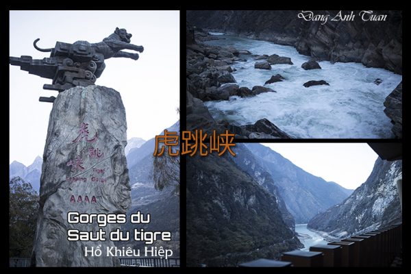
Hổ Khiếu Hiệp mà người Hoa gọi là hẻm núi hổ nhảy được hình thành trên dòng sông Kim Sa (Jinsha), một nhánh của sông Dương Tử. Nó là một danh thắng nổi tiếng nằm cách xa thành phố Lệ Giang 60 cây số về phía bắc thuộc tỉnh Vân Nam và xa Trung Đạo (Zhong Dao) nay là Shangrila một trăm cây số. Nó dài khoảng 16 cây số nằm giữa hai núi Tuyết Ngọc Long (Yulong Xue Shan) cao 5596 thước và núi tuyết Cáp Ba (Haba Xue Shan) cao 5396 thước với một loạt 18 ghềnh thác được bao quanh bởi những vách đá dựng đứng, vực sâu hun hút, có 2000 thước, và được cho là hẻm núi sông sâu nhất thế giới.
Truyền thuyết còn kể rằng có một con hổ đã nhảy từ bờ này sang bờ kia để thoát khỏi một thợ săn… nhưng lối đi hẹp nhất hiện nay chỉ là 30 thước. Khi bạn nhìn thấy sức mạnh của dòng sông cuồn cuộn ở phía dưới chân bạn thì bạn sẽ hiểu vì sao cú nhảy ấy nó lại trở thành huyền thoại.
Dân cư sống ở nơi nầy là người Nạp Tây (Naxi). Đây là một trong 56 dân tộc thiểu số sống ở Vân Nam và tộc người duy nhất còn dùng hình tượng chữ (dongba). Họ có nguồn gốc từ người Khương sống định cư trên cao nguyên Tây Tạng vào thời cổ. Họ sống rải rác ở các làng mạc của các thị trấn và mưu sống bằng nghề sản xuất ngũ cốc và du lịch ngày nay. Chớ trước đó họ cùng người Hán, người Tạng hay thường dùng qua nhiều thế kỷ các con đường mòn dành cho lừa đi về những nơi tiêu thụ trà và các hàng hóa khác như lông thú, xạ hương,muối vân vân.. ở các vùng cao nguyên Tây Tạng và Trung Quốc (Đại Lý, Lệ Giang và Đức Kinh (Shangrila). Bởi vậy màng lưới của các con đường mòn nầy nó mới có tên gọi là đường trà hay trong tiếng quan thoại chámgudào dù nó không nổi tiếng như con đường tơ lụa mà chúng ta biết nhưng phong cảnh nó rất ngoạn mục theo lời kể của những người thích đi bộ đường dài (trekking).
Etant connues sous le nom chinois 虎跳峡 (Hu tiào xiá), les gorges du Saut du Tigre, se sont formées sur la rivière Jinsha, un affluent du Yangtsé. Ce site pittoresque se situe à 60 kilomètres au nord de Lijiang, dans la province du Yunnan, et à 100 kilomètres de Zhongdao (aujourd’hui Shangri-La). Longues d’environ 16 kilomètres, elles s’étendent entre le Yulong Xue Shan ( 5596 mètres d’altitude) et le Haba Xue Shan (5396 mètres d’altitude), offrant un série de 18 rapides et de cascades entourés de falaises abruptes et d’une gorge profonde de 2000 mètres, ce qui leur vaut d’être considérées comme les gorges fluviales les plus profondes du monde.
La légende raconte qu’un tigre aurait sauté d’une rive à l’autre pour échapper à un chasseur… mais le passage le plus étroit ne mesure que 30 mètres de large. Face à la puissance de la rivière tumultueuse, on comprend aisément pourquoi ce saut est devenu légendaire.
Les habitants de cette région sont les Naxi. Ils font partie des 56 minorités ethniques du Yunnan et sont les seuls à utiliser encore l’écriture Dongba (pictogramme). Ils descendent du peuple Qiang, installé sur le plateau tibétain depuis l’Antiquité. Ils vivent dispersés dans les villages des bourgades, et tirent leurs revenus de la production céréalière et du tourisme. Autrefois, ils empruntaient, avec les Han et les Tibétains, les sentiers muletiers pour se rendre sur les marchés du plateau tibétain et de la Chine (Dali, Lijiang et Dejing/Shangrila) avec leurs produits (fourrure, musc, sel, thé etc. Ce réseau de sentiers est ainsi appelé la Route du Thé, ou « chámgudào » en mandarin. Bien que moins célèbre que la Route de la Soie, elle offre des paysages à couper le souffle, selon les amateurs de la randonnée.
Being known in pinying 虎跳峡 (Hu tiào xiá) by the Chinese, Tiger Leaping Gorge was formed on the Jinsha River, a tributary of the Yangtze River. It is a famous scenic spot located 60 kilometers north of Lijiang City in Yunnan Province and 100 kilometers from Zhong Dao, now Shangrila. It is about 16 kilometers long, situated between two mountains: Jade Dragon Snow Mountain (Yulong Xue Shan) at 5596 meters and Haba Snow Mountain (Haba Xue Shan) at 5396 meters, featuring a serie of 18 rapids surrounded by steep cliffs and a deep abyss of 2000 meters, considered the deepest river gorge in the world.
Legend has it that a tiger once jumped from one bank to the other to escape a hunter… but the narrowest passage today is only 30 meters. When you see the power of the rushing river below your feet, you will understand why that leap became a legend.
The inhabitants of this region are the Naxi. They are part of the 56 ethnic minorities of Yunnan and are the only ones still using the Dongba script. They descend from the Qiang people, who settled on the Tibetan plateau since ancient times. They live scattered in villages of small towns, earning their income from cereal production and tourism. In the past, they, along with the Han and Tibetans, used mule trails to reach the markets of the Tibetan plateau and China (Dali, Lijiang, and Dejing/Shangrila) with their products (fur, musk, salt, tea, etc.). This network of trails is thus called the Tea Horse Road, or « chámgudào » in pinying. Although less famous than the Silk Road, it offers breathtaking landscapes, according to hiking enthusiasts.