
Version française
Version anglaise
Liste des photos
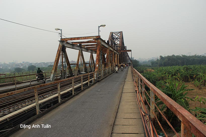
Ai có đến Hànôi hay đi tham quan vịnh Hà Long thì ít nhất cũng trông thấy cầu nầy từ đằng xa vì nó là cầu thép nối hai quận Hồ Hoàn Kiếm và quận Long Biên bắc qua sông Hổng, một con sông rất dài xuất phát từ Vân Nam và đổ ra biển Đông cuối cùng. Nó mang nhiều tên qua nhiều thế kỷ. Sông nầy chỉ quen thuộc đối với thời cận hiện đại với tên sông Hồng chỉ có từ cuối thế kỷ XIX , dưới thời Pháp thuộc khi người Pháp ho dựa trên màu nước của đất phù sa mà đặt một tên thống nhất. Chính con sông nầy nó làm giàu có vùng đồng Bắc Bộ nơi mà các nhà sữ gia Tây Phương và Việt cho đây là cái nôi của dân tộc Việt Nam. Còn cái cầu nầy nó được khởi công xây dựng tháng 9 năm 1898 dưới thời kỳ Pháp thuộc với toàn quyền Paul Doumer và hoàn thành hơn 3 năm sau. Cầu nầy được thiết kế do hãng Daydé & Pillé nhưng kiểu dáng quá độc đáo không thua chi đã trông thấy với các cầu của Gustave Eiffel vì vậy có sự nhầm lẫn nầy vã lại không phải là phương án thiết kế của Gustave Eiffel vì trên trang nhà của các người thừa kế của ông nầy không có liệt kê phương án nầy (http://www.gustaveeiffel.com/ouvrage/routiers.html).
Hiện trên đầu cầu vẫn còn tấm biển kim loại có khắc chữ « 1899 -1902 – Daydé & Pillé – Paris ». Nhưng cũng phải công nhận đây là một kỳ công về kỹ thuật và công việc hậu cận vì thời đó nó là một trong bốn cầu dài nhất thế giới (nhất là ở Viễn Đông ) và ngành công nghiệp thép bản xứ hầu như không có, xứ Pháp thì quá xa vời. Cây cầu dài 1.862m, gồm 19 nhịp dầm thép, đặt trên 20 trụ cầu cao 43,50m. Ở giữa cầu là đường xe lửa, hai bên có đường rộng 1,3m, từng quãng một có những chỗ rộng nhô ra, nơi những ngừơi nghèo thường bán đồ. Toàn bộ chiều dài của cầu lên tới 2.500m.
Nó là cầu chứng kiến những thăng trầm lịch sữ của đất nước. Cầu nầy được vua Thành Thái và Toàn quyền Đông Dương đến đầu cầu để làm lễ khánh thành dưới thời Pháp thuộc. Nó cũng là cầu mà ngày 10/10/1954, quân đội viễn chinh Pháp lặng lẽ cuốn gói rời khỏi Hànội sau trận chiến ở Điện Biên Phủ. Nó bao lần bị oanh tạc hư hao trong thời kỳ chống Mỹ. Nay sang thời bình, sau thập kỷ 90, cầu Long Biên được sử dụng chỉ cho tàu hỏa, xe đạp, xe máy và người đi bộ từ khi có cầu Chương Dương nằm trong mục tiêu đáp ứng nhu cầu đi lại và để phát triển kinh tế, xã hội đô thị ở hai bờ sông Hồng. Với nét cổ kính, nó còn là nơi lý tưởng dành cho giới trẻ Hà Thành muốn chụp ảnh đám cưới hay lưu niệm. Hôm tôi đến đây chụp thấy ớn quá chừng có nhiều người đứng giữa cầu chụp nhất là có tàu hỏa thường tới lui trên cầu. Chỉ có ở đất nước mình mới thấy sự táo bạo như vậy mà thôi. Tôi còn nhớ em đó nói có chi đâu anh khi nghe còi thì chạy vào mà thôi. Một hình ảnh khó quên.
Quiconque ayant l’occasion de venir à Hànội ou d’aller à la baie d’Along peut voir au loin ce pont en acier. Celui-ci relie les deux districts Hồ Hoàn Kiếm et Long Biên en enjambant le long fleuve Rouge issu de la grotte de Yunnan en Chine et terminant sa course dans la mer de l’Est. Ce fleuve a plusieurs noms au fil des siècles. Il est plus connu familièrement sous le nom actuel « Fleuve Rouge » à la fin du XIXème siècle. En voyant la couleur alluviale de son eau et en voulant uniformiser les noms portés par ce fleuve, les Français lui ont donné, à l’époque coloniale, le nom « Fleuve Rouge« . C’est lui qui nourrit et enrichit la région du delta du Nord que les historiens occidentaux et vietnamiens ont considérée toujours comme le berceau de la civilisation vietnamienne. En ce qui concerne le pont, il fut construit à l’époque coloniale en 1898 et achevé 3 ans plus tard sous l’initiative du gouverneur de l’Indochine, Paul Doumer. Le projet de conception et de réalisation de ce pont était assumé par la société Daydé & Pillé. Comme sa forme et son style ressemblent à ceux des ponts de Gustave Eiffel, il y a là une confusion énorme en attribuant cet ouvrage à ce dernier.
De plus, dans la liste des ponts routiers réalisés par Gustave Eiffel (http://www.gustaveeiffel.com/ouvrage/routiers.html), le pont Paul Doumer ne figure pas.
Par contre, on trouve encore aujourd’hui à l’entrée de ce pont, une plaque métallique portant le nom de la maison Daydé & Pillé et sa date de réalisation. Il faut reconnaître que ce pont est un remarquable ouvrage d’art de l’époque, une prouesse technique et logistique, vu la faiblesse de la sidérurgie locale et l’éloignement de la France. Il est l’un des quatre ponts les plus longs du monde ( le premier en Extrême Orient). Long de 1862 mètres, il comprend 19 travées solidaires formées de poutres d’acier du type Cantilever et repose essentiellement sur une vingtaine de colonnes solides hautes de 43,50 mètres. De chaque côté du pont, il y a un petit trottoir réservé pour les piétons et une piste pour les vélos et les motos tandis qu’au milieu se trouvent les rails pour les trains. La longueur totale de ce pont atteint jusqu’à 2500 mètres.
Il est le témoin majeur des hauts et des bas de l’histoire du Vietnam. Il fut inauguré par l’empereur Thành Thái en présence du gouverneur de l’Indochine Paul Doumer à l’époque coloniale. C’est aussi par ce pont que les troupes françaises empruntèrent en Octobre 1954 pour quitter Hànoï après la chute de Điện Biên Phủ. Il était maintes fois la cible privilégiée des bombardements durant la guerre contre les Américains.
Après la décennie des années 1990 marquée par la paix, le pont Long Biên est réservé uniquement pour les trains, les vélos, les scooters et les piétons depuis qu’i l existe le pont Chương Dương répondant aux développements économiques et à l’urbanisation de deux côtés du fleuve Rouge.
Avec son charme antique, il devient aujourd’hui l’endroit idéal fréquenté par la jeunesse hanoienne pour immortaliser son mariage ou son souvenir. Le jour où j’étais de passage pour faire des photos, je m’aperçus qu’il y avait quelques jeunes gens empruntant la voie du milieu fréquentée par les trains pour être photographiés. C’est une audace effarante qu’on peut trouver seulement au Vietnam au détriment de la vie. C’est difficile d’oublier cette scène.
Anyone who has the chance to come to Hanoi or go to Ha Long Bay can see in the distance this steel bridge. It connects the two districts Hồ Hoàn Kiếm and Long Biên by spanning the long Red River, which originates from the Yunnan cave in China and ends its course in the East Sea. This river has had several names over the centuries. It is more familiarly known by its current name « Red River » since the late 19th century. Seeing the alluvial color of its water and wanting to standardize the names carried by this river, the French gave it, during the colonial period, the name « Red River. » It nourishes and enriches the northern delta region, which Western and Vietnamese historians have always considered the cradle of Vietnamese civilization. Regarding the bridge, it was built during the colonial period in 1898 and completed 3 years later under the initiative of the governor of Indochina, Paul Doumer. The design and construction project of this bridge was undertaken by the company Daydé & Pillé. Since its shape and style resemble those of Gustave Eiffel‘s bridges, there is a huge confusion attributing this work to him.
Moreover, in the list of road bridges built by Gustave Eiffel (http://www.gustaveeiffel.com/ouvrage/routiers.html), the Paul Doumer Bridge does not appear.
However, even today at the entrance of this bridge, there is a metal plaque bearing the name of the Daydé & Pillé company and its date of completion. It must be acknowledged that this bridge is a remarkable work of art of its time, a technical and logistical feat, given the weakness of the local steel industry and the distance from France. It is one of the four longest bridges in the world (the first in the Far East). Measuring 1862 meters long, it comprises 19 solid spans formed of Cantilever-type steel beams and rests mainly on about twenty solid columns, each 43.50 meters high. On each side of the bridge, there is a small sidewalk reserved for pedestrians and a lane for bicycles and motorcycles, while in the middle are the rails for trains. The total length of this bridge reaches up to 2500 meters.
It is a major witness to the ups and downs of Vietnam’s history. It was inaugurated by Emperor Thành Thái in the presence of the Governor of Indochina, Paul Doumer, during the colonial era. It was also via this bridge that French troops passed in October 1954 to leave Hanoi after the fall of Điện Biên Phủ. It was repeatedly a prime target for bombings during the war against the Americans.
After the decade of the 1990s marked by peace, the Long Biên Bridge has been reserved only for trains, bicycles, scooters, and pedestrians since the Chương Dương Bridge was built to meet the economic developments and urbanization on both sides of the Red River.
With its antique charm, it has become today the ideal place frequented by Hanoi’s youth to immortalize their wedding or memories. The day I was passing by to take photos, I noticed that there were some young people using the middle lane, frequented by trains, to be photographed. It is a staggering audacity that can only be found in Vietnam at the risk of life. It is hard to forget this scene.