La bourgade de Đồng Văn (Phố cổ Đồng Văn)

Version française

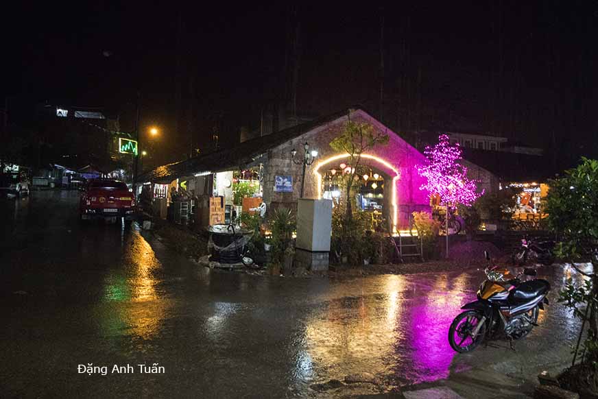
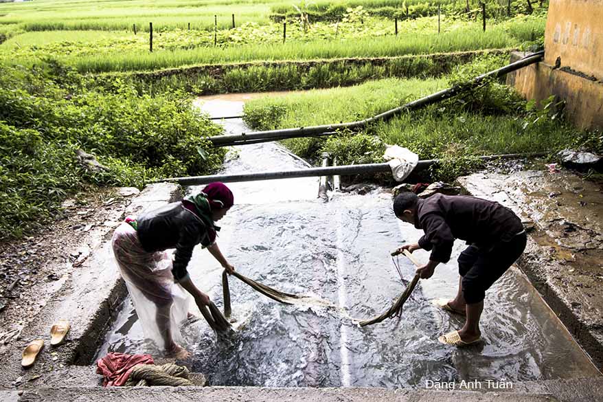
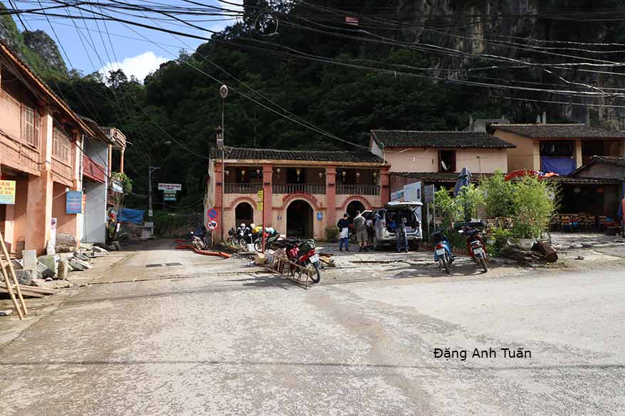
Nằm ở giữa lòng thung lũng của cao nguyên đá Đồng Văn, phố nầy lúc ban đầu có khoảng chừng 40  cái nhà mà thôi. Khu phố nầy được thành hình vào đầu  thế kỷ 20 dưới chân núi  với vài gia đình người Hmong, người Tày và người Hoa. Bởi vì được xây cất với các thợ  được thuê đến từ Tứ Xuyên nên các nhà ở đây mang dấu ấn  khá  sâu đậm của người Hoa qua lối kiến trúc hai tầng trình tường, mái  ngói âm dương và trước cửa nhà có đèn lồng treo cao. Nay trở thành một địa điểm quan trọng mà du khách không thể bỏ qua được khi đến Hà Giang. Nhà cửa ở đây cũng xây cất lại, nhà trọ cũng có nhiều, giá cả cũng  phải chẵn, du khách ngoại quốc nhất là dân đi phượt cũng đông cuối tuần và thích ngủ nhà sàn. Rất tiếc chiều hôm đó, mưa quá to nên chụp hình không được nhiều. Chỉ sáng hôm sau, trời lại nắng nên mới có vài tấm ảnh để lưu niệm nhưng cũng có dịp viếng thăm một nhà cổ của người Hmong nay thành nhà trọ và có dịp chứng kiến cách thức dùng nước suối rửa cây linh (lin)  trước khi dệt vãi.  Đi miền núi như mình rất mệt nhưng  học hỏi rất nhiều về tập quán nhất là Hà Giang có đến 22 dân tộc thiểu số  và rất thích thú trong cuộc hành trình nầy. 

bourgade_dong_van

Située au cœur de la vallée du plateau karstique de Đồng Văn, cette bourgade avait  seulement au moment de sa construction  une quarantaine de maisons.  Elle prit forme au début  du XX ème siècle au pied des montagnes rocheuses avec quelques familles Hmong, Tày et Hoa (ou Chinois).  Comme ses maisons ont été construites par des ouvriers recrutés  venant de Sichuan, cette bourgade continue à garder  une  profonde empreinte chinoise à travers son architecture typique à deux étages, son toit avec des tuiles tubulaires âm dương et ses lampions suspendus devant l’entrée. Aujourd’hui, elle devient un passage obligatoire pour ceux qui visitent Hà Giang.  La plupart de ses maisons sont rénovées et ses « homestay » (logement chez l’habitant) sont nombreux avec un prix assez raisonnable. Les touristes étrangers  sont en majorité des routards ou des gens aimant l’aventure de l’extrême et préférant dormir dans des maisons sur pilotis   et ils sont nombreux à la fin de la semaine.   C’est regrettable pour nous d’avoir la pluie torrentielle le soir de notre arrivée. C’est seulement le lendemain avec le retour du soleil que je peux faire quelques photos ci-dessus. J’ai aussi l’occasion de visiter une vieille maison devenant aujourd’hui un  « logement chez l’habitant » et d’apprendre la façon de laver le lin avec l’eau de source  avant le tissage des vêtements pratiqué par les Hmong.  L’excursion à la montagne est épuisante   mais elle me permet d’avoir des choses à apprendre en particulier les coutumes et les traditions lorsque la région Hà Giang a 22 minorités ethniques. Je suis très content de ce voyage mémorable. 

Huế city (English version)


titre_hue 

Version française

For the majority of Vietnamese, Huế always remains the intellectual and artistic foyer of Vietnam. It always looks like a sleeping princess. It knows how to keep its charm and grace that it has had since the Champa occupation with its citadel, the Perfume river and above all the famous Thiên Mụ ( or The Celeste Lady ) pagoda . The cruel beauty of its women wearing the white tunic ( áo dài ) accompanied by a conical hat (or nón bài thơ) , the fineness of its poetry, the union of its parks and pagodas with varnished tiles, the culture of its madarinal court make it more charming, noble, and majestuous.

One remembers Hue through the follwing two famous popular verses:

Gió đưa cành trúc là đà
Tiếng chuông Thiên  Mụ, canh gà Thọ-Xương

While the wind smootly moves the bamboo branches 
One hears the Thiên Mụ bell, and the Thọ-Xương rooster’s song

Before becoming the imperial capital of the Nguyễn, it was first the strong place of Chinese Jenan’s command of emperorQin ShiHuangDi in 3rd century B.C., then it was gradually integrated in the kingdoms of Lin Yi and Champa since 284 of our era. Then it was the object of greed of the Chinese and the Vietnamese when the latter  gained their independence. It was partially controlled by the Vietnamese in 1306. This control was only wholly when Hue became a dowry from king Chế Mẫn of Champa to the Vietnamese in exchange of his marriage with princess Huyền Trân.

Cố Đô Huếtucam

It was the imperial capital of a reunified Vietnam from 1802 to 1945 and knew no less than 13 emperors of the Nguyễn dynasty, of whom the founder was Nguyễn Ánh known under the name of  » Gia Long ». On the left bank of the Perfume river, in the middle of the city center, three surroundding walls circumscribe the imperial city and protect the forbidden purple city whose orientation was set in relationship with four cardinal points by geomancers of the court. As an admirer of the Ming dynasty, emperor  Gia Long did not hesitate to give Huế a striking resemblance of the Forbidden City of Peking.

Pictures gallery

The royal tombs were built  at the exit of the city, along the river. Hue was the target of several conquests, French first in 1885, Japanese next in 1945 and then French in 1946. It was the witness of deadly combats during the Mậu Thân Tết offensive in 1968. Many times, it was also the actor of nationalist resistance in colonial time and during the last five decades.

Despite its aristocratic appearance, Huế knows how to conserve in difficult time the history of Vietnam that is to say the Vietnamese soul.

Mandarin road (English version)

Version française

Mandarin road

If a tourist has a chance to travel by car from Saigon to Hanoï, he has got to take the « mandarin route » (or route No.1 ) as it is the only one that exists on the road network in Vietnam. We owe the name of « mandarin route » to the French who named it in 19th century because it is certain that it was the road taken by mandarins and high functionaries to travel rapidly and easily between the capital and their provinces. This route is born in the swamps of  Mekong delta infested with mosquitoes. It begins at Cà Mau and ends at the post of Ðồng Ðằng on the Sino-Vietnamese border in the region close to Lạng Sơn. It is often said that this route is the country’s backbone that looks like a sea horse. This route is 1730km long, linking several cities, in particular Saigòn, Phan Thiết, Nha Trang, Qui Nhơn, Hội An, Ðà Nẵng, Huế, Ðồng Hới, Hà Tịnh, Thanh Hóa and Hanoï.

It is generally covered with asphalt, but often on some sections, it was badly paved and weighed down by a multitude of trucks, bicycles, pedestrians, buffaloes, cows, and troops of ducks walking on. The bitumen often breaks, causing the grandmother perching side-saddle on the baggage carrier and girls leaning on too big bikes, to jump. Those are the familiar scenes often encountered on this road.

One also finds harvested rice and manioc left to dry on asphalt heated by the sun in the North. On this route, one can see on a side of Sa Huynh, the salt fields or mounds of salt recovered from the foliage and set up alongside of the road. The further one goes north, the more one sees peaceful landscapes of flooded rice paddies.

One often crosses children leading herds of buffaloes daubed with mud. At the edge of Hoa Lư, the ancient capital of Viet Nam, silhouettes of rocky hills emerge from the bluish mist.

Despite its bad condition especially in North Vietnam, it continues to be the axle road vital to Vietnam. For those who like to know the history of Vietnam, the history of the long march towards the South, it is suggested that this route be borrowed because one would find not only the vestiges of a lost civilization in the whirlwind of history, the kingdom of Champa, but also the marks and traces that Vietnamese settlers, for the past decades, succeeded in carving during their passage.

Pictures gallery

Quốc lộ số 1

To know this route is to know not only the immense rice paddies, rubber tree plantations, beautiful sightseeing points on the coast of Vietnam, very beautiful panoramic views from one delta to another, superbs passes (in particular the Hải Vân pass) and wooded hills, almost desolate waste lands, but also an intensity of a Vietnamese agricultural life through hamlets located alongside of the route.

To know this route is to also know the Hiền Lương bridge. It was built by the French in 1950, destroyed by an American airplane in 1967, 178 meters long. It certainly evokes an episode when Viet Nam was divided and when one-half of the bridge was painted red and the other half yellow. It is located at the 17th parallel, in a zone where one of its sections, known during the Indochina war as « the Road without Joy » as French troops encountered fierce resistence there.

To know this route is to know the Hải Vân pass. It is located at 28km north of Ðà Nẫng ( or Tourane ) and only 495m high. As its name indicates, it is always in the clouds because it is close to the sea, which allows it to receive important masses of humid air. In the old days, it marked the frontier between the North and the South and protected the Chams from the Vietnamese appetite for land.

Composer Phạm Duy has evoked this route through his work entitled « Con Ðường Cái Quan« .


Dalat (English version)

Version française

  Thành phố sương mù

Located on the Vietnam’s Central Highlands, about 250 kilometers from Saigon and  1500 meters above sea level, Dalat continues to keep the charm of the 1920s.

In 1893, the discoverer of the plague bacillus and the Pasteur’s disciple, Alexandre Yersin has founded at the Lang Bian mountain plateau  a fertile ground for the establishment of a sanatorium. His project was followed several years later by that of Governor Paul Doumer in transforming Dalat into  the  most select climate  resort of South East Asia.
Here is found the little Paris of the Viet Nam with its buildings erected during the colonial era:  high school Yersin, convent of the sisters named “Couvent des Oiseaux”, private villas whose style is borrowed from Basque country, as well as from to  Savoy and Normandy.

The railway station of Đà Lạt is a replica of the Deauville train station in miniature. Even the small red and white iron lady, the small Eiffel Tower is there to remind its Parisian colleague.

 Little Paris in Vietnam

Pictures gallery 

Thanks to the temperate climate (10 degrees in  winter) and 25 degrees in  summer, one can cultivate here  all citrus fruits and vegetables. That allows Dalat to become the  leading vegetable provider of the country. Flowers greenhouses are also in the honour  for the region. Known as  « the city of eternal spring », Dalat is characterized by a large number of « no »: no air conditioning, no traffic lights, no cycle ricksaws, no cops in  the streets, no supermarkets, no motorcycle taxis (xe ôm) etc..

Capital Hanoï (Vietnam)

Version française

Thăng Long muôn thưở 

As indicated by its name Hà Nội means « The city on this side of the river » (Hà means river, Nội means inside). Contrary to other cities in Vietnam, Hanoï has a long agitated history. Its destiny is that of the Vietnamese people. It experienced a long period of disgrace when Nguyễn Ánh arrived at founding the Nguyen dynasty in 1802 after 20 years of fighting the Tây Sơn and decided to transfer the capital to Huế (or Phú Xuân). It witnessed several decisive battles in the reclaim of independence, in particular the Đống Đa battle run by Emperor Quang Trung in 1789. Thanks to the blitzkrieg upon Chinese troops of Qing, and to Quang Trung’s scheme to choose the date of the Vietnamese new year to surprise the Chinese enemy, Hanoï was thus liberated as well as Vietnam. It was also chosen by Hồ Chí Minh to proclaim Vietnam’s independence on September 2, 1945 at Ba Đình Square.

It was also on one of its lakes under the name of Hồ Gươm where Lê Lợi, future king Lê Thái Tổ, after his victory over the Ming, according to a Vietnamese legend, returned his magic sword to a golden tortoise which gave him this sword during a walk. Thanks to this sword, Lê Lợi succeeded in chasing Chinese troops of Ming out of Viet Nam after 10 years of fighting a guerilla warfare. That is why the lake is known as « Lake of Returned Sword » (or Hồ Hoàn Kiếm).

It was also at Hanoï that the unique one-pillar pagoda (Chùa Một Cột) was erected in 1049 by king Lý Thái Tông on a strong wooden pillar in the style of ancient temples of ancestors. According to legend, the king afflicted by not having a descendant, saw in his dream Quan Âm, the Goddess of Compassion. Sitting on a lotus flower, she gave him a son. Shortly after that, a young country girl that he made favorite, gave him an heir. In witness of his gratitude, he had this pagoda erected in the middle of a pond of lotus flowers.

Because of its proximity to the Red river, every year Hà Nội is victim of floodings caused by the cresting of this river and by violent monsoon rain and typhoons.

In spite of that, Hà Nội continues to remain the capital of a unified Vietnam. No one dares to contest the political and cultural heritage it has left to the Vietnamese people. It represents not only for the majority of Vietnamese the symbol of national unity but also the pride of a people of peasants who know how to valiantly resist the changes of nature and the ambitions of invaders.

Hànội vắng những cơn mưa

Saxophoniste Quyền Văn Minh

Pictures gallery


Thăng Long muôn thưở

Before becoming the capital city of Việt-Nam, Hà Nội was the seat of the Chinese administration in 607 and bore the name of « Tống Bình« . In 866, this seat was surrounded by the wall of Ðại La whose some vestiges still exist. It was chosen by the founder of the Lý dynasty, king Lý’ Công Uẩn, in 1010 as a new capital of Vietnam at the place of Hoa Lư.

According to legend, in his dream the king saw a golden dragon flying over that locality. That is why Hà Nội was called at that time « Thăng Long » (ascending dragon)« .

This site was deemed favorable in comparison with other sites because it is located between « hà » and « sơn », waters and mountains, in the middle of rice paddies and protected from flooding by dikes. In 15th century, Hà Nội took the name of Ðông Kinh. Then it retook the name of Thăng Long until the transfer of the royal residence to Huế. Next, it took the name of Thành Tích then Bắc Thành before becoming Hà Nội only in 1931. It became the capital of North Viet-Nam after the Geneva Accord in 1954 and since the events of 1975, the capital of reunified Viet-Nam.

Hà Nội covers 913km2. Its interior (or nội thành 40km2) is divided into four urban districts (or Quận): Quận Hoàn Kiếm, Quận Hai Bà Trưng, Quận Ðống Ða, and Quận Ba Ðình. It also includes six suburban districts (or Huyện) and several villages located within its limits.

One finds the soul of Hà Nội through its old city. Poetess Bà Huyện Thanh Quan, a poetess of 19th century evoked it in one of her works.
What retains the most in that old city are the 36 streets that are often known as Hàng (or merchendise in English). There, each cratfsman makes his specialty object and each street was baptized following the craft that was practiced there: street of Silk, street of Drums, street of Potteries etc… Novelist Thạch Lam talked about it in his novel « Hà Nội, 36 Phố Phường« . Hà Nội is also the Vietnamese city which keeps more colonial traits compared to other cities. It can be said that it is the conformed copy of a French town in the structure of Arcachon, with its governor’s palace, opera house, post office and park. The bridge Long Biên (or Paul Doumer) recalls not only the first work of art of French builders on the Red river in 1902 but also the traces of American bombings during the Vietnam War.

In spite of that, Hanoï, from the past few years begins to change its face and look. Constructions have been multiplied at such a rhythm that there is not one square meter unoccupied. It tries to catch up with its late economy and to fill in the incoming vacuum left by the return of Hong Kong to China.

Villes de France


Villes de France (Các thành phố Pháp Quốc)
Un castel médiéval au cœur du Périgord noir.
Một lầu đài thời trung cổ ở giữa lòng của Périgord
Une ville très charmante avec ses maisons à colombage dans le quartier historique « La Petite France ».

Một thành phố Strasbourg xinh xắn với các nhà nửa gỗ ở giữa lòng khu phố cổ được gọi là "nước Pháp nhỏ bé".

Strasbourg (Marché de Noël 2017)
Le jardin d'eau de Claude Monet. (Giverny)

Vườn hoa súng của họa sỹ Claude Monet (Giverny).
Le jardin d’eau de Claude Monet (Giverny)

Le clos normand de Claude Monet (Giverny).
La roseraie de l'Hay-les-Roses (Val de Marne 94)
Vườn hoa hồng L'Hay-les-Roses.
Le village médiéval Eze de la Provence. Làng thời trung cổ Eze.
Village d’Eze (le plus beau village de France)
Le vieux port, symbole de la ville la plus ancienne de la France, Marseille.
Cảng cũ, biểu tượng của thành phố cổ nhất của nước Pháp, Marseille.

Marseille, la ville la plus ancienne de la France

Strasbourg (Marché de Noël 2017)


Située à deux heures de la capitale Paris au nord-est de la France avec le train TGV, Strasbourg est une ville très charmante avec ses maisons à colombage dans le quartier historique localisé sur la Grande Île, qui est classée au Patrimoine mondial de l’Humanité par l’UNESCO depuis 1988. Elle est très connue pour son vieux marché de Noël en Europe.


Nằm ở phía đông bắc nước Pháp cách thủ đô Paris hơn hai giờ tàu tốc hành TGV, thành phố Strasbourg mơ mộng với những ngôi nhà xinh xắn ven các kênh đào trong khu lịch sữ La Petite France được công nhận là di sản thế giới từ năm 1988 bởi UNESCO. Strasbourg còn nổi tiếng là có chợ đêm Noël lâu đời nhất ở Âu Châu.

Bấm vào hình để xem ảnh rõ hơn (Cliquez sur l’image pour l’agrandir)

Paris 2017

paris
Paris est l’une des plus belles villes du monde, en particulier la nuit. Comme l’écrivain américain Ernest Hemingway disait qu’il n’y a que Paris pouvant lui apporter  à tout instant,  l’inspiration dans la création de ses œuvres littéraires. Pour lui, Paris était considéré  toujours comme  une fête (The Moveable feast) lors de son séjour à la fin des années 1950. Il y a non seulement la Seine coulant paisiblement  sous les ponts  ayant chacun une architecture particulière mais aussi des lieux très célèbres comme le jardin de Luxembourg, la cathédrale Notre Dame, la tour Eiffel, le musée du Louvre etc…C’est pour cela que Paris lui a exercé un attrait irrésistible même il était de passage à Paris pour une fois. C’est aussi Paris  qui a fait de lui un écrivain célèbre.

Version vietnamienne

Paris là một trong những thành phố đẹp nhất thế giới nhất là về đêm. Cũng như nhà văn hào Mỹ Ernest Hemingway nói   chỉ có Paris có thể đem lại cảm hứng sáng tác cho ông bất kỳ lúc nào. Chính vì thế ông xem Paris lúc nào cũng như ngày lễ hội.  Không những  có  sông Seine trôi lặng lẽ dưới các cây cầu có một  kiến trúc độc đáo  mà còn các nơi nổi tiếng  như vườn hoa Luxembourg,  nhà thờ Notre Dame,  tháp Eiffel, bảo tàng viện Louvre vân vân khiến   Paris trở thành nơi có sức lôi cuốn mãnh liệt đối với ông dù ông chỉ có một lần đến Paris.  Chính Paris làm ông trở thành một nhà văn hào nổi tiếng.

Paris 2017

Một thoáng trở về với Luông Phạ Băng (Luang Pra Bang)

Những khoảnh khắc Luông Phạ Băng


Từ thế kỷ 14 đến 1946, Luông Pra Băng hay Mường Luông là kinh đô của một vương quốc đuợc mang tên là Lan Xang hay là vuơng quốc triệu voi. Luang Pra Bang được UNESCO công nhận là một di sản thế giới (văn hóa). Nằm bên cạnh sông huyèn thoại  Cửu Long, Luông Phạ Băng cách xa Viên Chăn (Vientiane) 425 cây số về phía Bắc. 

Depuis le 14 ème siècle jusqu’à l’année 1946, Luong Pra Bang fut la capitale du royaume de Lan Xang (ou royaume du million d’éléphants). Luang Pra Bang est reconnue par UNESCO comme le patrimoine culturel de l’humanité. Longeant le  fleuve mythique Mékong, elle est  située à 425 km de  la capitale Vientiane  dans la direction nord.