Mang Khảm (Hà Tiên)

Version française

Version anglaise

Đối diện với vịnh Xiêm La, Hà Tiên một tỉnh lị nằm cách xa  khoảng 8 cây số với biên thùy Cao Miên.  Đây cũng là thành phố đánh dấu sự kết thúc cuộc hành trình  Nam Tiến của người dân Việt.  Trước khi được  biết với tên Hà Tiên, tỉnh lị nầy thường được gọi buổi đầu với tên Phương Thành sau đó có tên Mang Khảm. Lúc đầu rất hoan sơ, sau đó có sự phát triển kinh tế ở nơi nầy đó là nhờ  việc di cư ồ ạt của các phần tử thân triều đình nhà Minh (hay Minh Hương) mà trong đó có một  người nổi tiếng tên là Mạc Cửu.(Mac King Kiou)

Không khuất phục chính sách của Đại Thanh và rời  bỏ Trung Hoa vào lúc 17 tuổi,  ông sang định cư cùng gia quyến ở Nam Vang ( Cao Miên) năm 1671. Vài năm sau, ông được chức Ốc Nha phong  bởi vua Chân Lạp ( Cao Miên),  xem như là tri phủ hay là tỉnh trưởng  thời đó của Mang Khảm. Nhờ có óc buôn bán và tính hào hiệp, ông đã thành công trong việc biến  Mang Khảm một tỉnh lị nhỏ bé thành một thương cảng sầm uất , buôn bán  phồn thịnh  trong vùng. Để tránh  tham vọng  của người Xiêm La, ông cần sự bảo trợ của  người dân việt nhất là của  các chúa  Nguyễn chớ vua Cao Miên không  có đủ thế lực để bảo vệ ông. Vì lý đó, ông xin qui phục Nam Triều.  Từ đó Mang Khảm thuộc về lãnh thổ Việt Nam và lấy tên Hà Tiên.

Theo truyền thuyết dân gian thì có   thấy trên sông các vị tiên xuống trần tham dự cuộc du hồ (Hà có nghĩa là sông). Chính vì vậy mới gọi là Hà Tiên. Sau vài năm , Hà Tiên trở thành điểm xuát phát trong cuộc chinh phục các huyện của Chân Lạp: Long Xuyên (Cà Mau ngày nay), Kiên Giang (Rạch Giá), Trấn Giang (Cần Thơ), Trấn Di (Bạc Liêu) với con trai của Mạc Cửu:  Mạc Thiên Tứ. Ông nầy là một nhân vật phi phạm.  Định mệnh của ông rất liên hệ chặt chẽ với định mệnh của Nguyễn Ánh ( vua Gia Long ). Mạc Thiên Tứ trở thành công thần lừng danh của nhà Nguyễn trong việc chống chọi với nhà Tây Sơn. Với những năm lao đao của Nguyễn Ánh, Mạc Thiên Tứ buộc lòng sang Thái Lan nương thân cùng gia quyến với  Tôn Thất Xuân , một người chú của Nguyễn Ánh. Để làm người Xiêm La nghi ngờ tuyệt giao, quân Tây Sơn không ngần ngại làm giả mạo mật thư  nói rằng Mạc Thiên Tứ cùng bộ hạ sẻ làm nội ứng để lật đổ vua Xiêm La Trịnh Tân (Phraya Tak Sin). Tất cả gia đình của ông cùng Tôn Thất Xuân, tất cả 53 người  bị Trịnh Tân giết cả. Để bảo toàn danh dự và lòng trung thành, ông tuẫn tiết bằng cách nuốt vàng lá  vào miệng vào năm Canh Tý 1780, thọ hơn 70 tuổi. Mạc Thiên Tứ còn là một nhà thi sĩ nổi tiếng của thời đó. Chính ông là người làm  ra tập Hà Tiên Thập vịnh để ca ngợi các thắng cảnh tuyệt vời và thiên nhiên của Hà Tiên. Tập nầy khi lúc đầu  có được 10 bài sau đó được nhóm Chiêu Anh Các gồm có 31 thi sĩ, mỗi người 10 bài cho nên tổng cộng có  đến 320 bài  dưới sự khởi xướng của Mạc Thiên Tứ.  Sau cùng Nguyễn Cư Trinh có họa thêm 10 bài khiến tập nầy có một giá trị vô giá để lưu truyền cho hậu thế.

Hình ảnh 

Chúng ta cũng không thể quên bài thơ Lục Bát mà Mạc Thiên Tứ ứng khẩu để trêu nghẹo một cô gái Quảng Nam giả làm chàng   thư sinh tham dự trong một buổi  dạ hoa đăng:

Bên kia sen nở nhiều hoa
Người khen hoa đẹp nõn nà hơn em
Trên bờ em đứng em xem
Mọi người sao bỗng không thèm nhìn hoa

Không chút ngại ngùng, chàng thư sinh trả lời Mạc Thiên Tư như sau:

Mặt ao sen nở khắp
Trông hoa lẫn bóng người
Trên bờ ai đứng ngắm
Sao chẳng thấy hoa tươi?

Sau cuộc trao đổi thơ, Mạc Thiên Tứ mới khám phá được chàng thư sinh ấy là gái giả trai để tránh nạn cướp từ miền trung  đến , theo cha vào Hà Tiên buôn bán và tên là Nguyễn Thị Xuân. Mạc Thiên Tứ lấy nàng làm vợ lẽ nhưng nàng suýt chết vì sự ghen tương của bà vợ chánh nên đành rút về tu ở một am tự để sống hết quãng đời còn lại.  Trước khi mất, bà có để lại một bài thơ ví bà như một hoa sen , kể lại  sự trong sạch và cao thượng của bà trong một thế giới ghê tởm và đầy  ô nhục bẩn thỉu: 


Vươn khỏi bùn nhơ thoát vươn lên
Phỉ lòng trong trắng giữa thiên nhiên
Xuân thu đậm nhạt bao hồng tía
Ðừng sánh thanh cao với đóa sen.

hatien_2Nhắc đến Hà Tiên không thể nào không nghĩ đến Mạc Cửu và Mạc Thiên Tứ. Chính nhờ họ mà  Việtnam đã thành công cuộc Nam Tiến.  Cũng không có chi ngạc nhiên sự gắn bó sâu sắc và lòng kính nể mà người dân Việt dành cho Mạc Cửu và gia quyến nếu ai có lần đến thăm  viếng  đền của ông ở Hà Tiên.


Cầu Long Biên (Ancien pont Paul Doumer, Hànội)


Version française
Version anglaise
Liste des photos

Ai có đến Hànôi hay đi tham quan vịnh Hà Long thì ít nhất cũng trông thấy cầu nầy từ đằng xa vì nó là cầu thép nối hai quận Hồ Hoàn Kiếm và quận Long Biên bắc qua sông Hổng, một con sông rất dài xuất phát từ Vân Nam và  đổ ra biển Đông  cuối cùng. Nó mang nhiều tên qua nhiều thế kỷ. Sông nầy  chỉ quen thuộc đối với thời cận hiện đại với  tên sông Hồng  chỉ có từ cuối thế kỷ XIX , dưới thời Pháp thuộc khi người Pháp ho dựa trên màu nước của đất phù sa mà đặt một tên thống nhất. Chính con sông nầy nó làm giàu có vùng đồng Bắc Bộ nơi mà các nhà sữ gia Tây Phương và Việt cho đây   là cái nôi của dân tộc Việt Nam.  Còn cái cầu nầy nó được khởi công xây dựng tháng 9 năm 1898  dưới thời kỳ Pháp thuộc với toàn quyền Paul Doumer và hoàn thành  hơn  3 năm  sau. Cầu nầy được thiết kế do hãng Daydé & Pillé nhưng kiểu dáng quá độc đáo không thua chi  đã trông thấy với các cầu của Gustave Eiffel vì vậy có sự nhầm lẫn nầy vã lại không phải là phương án thiết kế của Gustave Eiffel vì trên trang nhà của các người thừa kế của ông nầy không có liệt kê phương án nầy (http://www.gustaveeiffel.com/ouvrage/routiers.html).

Hiện trên đầu cầu vẫn còn tấm biển kim loại có khắc chữ « 1899 -1902 – Daydé & Pillé – Paris ». Nhưng cũng phải công nhận  đây là một kỳ công về kỹ thuật và công việc hậu cận vì thời đó nó là một trong bốn cầu dài nhất thế giới (nhất là ở Viễn  Đông ) và ngành công nghiệp thép bản  xứ hầu như không có, xứ Pháp thì quá xa vời. Cây cầu dài 1.862m, gồm 19 nhịp dầm thép, đặt trên 20 trụ cầu cao 43,50m. Ở giữa cầu là đường xe lửa, hai bên có đường rộng 1,3m, từng quãng một có những chỗ rộng nhô ra, nơi những ngừơi nghèo thường bán đồ. Toàn bộ chiều dài của cầu lên tới 2.500m.   

Nó là cầu chứng kiến những  thăng trầm lịch sữ của đất nước. Cầu nầy được vua Thành Thái và Toàn quyền Đông Dương đến đầu cầu để làm lễ khánh thành dưới thời Pháp thuộc. Nó cũng  là cầu mà ngày 10/10/1954, quân đội viễn chinh Pháp  lặng lẽ  cuốn gói  rời khỏi Hànội sau trận chiến ở Điện Biên Phủ. Nó bao lần bị oanh tạc hư hao trong thời kỳ chống Mỹ.  Nay sang thời bình, sau thập kỷ 90, cầu Long Biên được sử dụng chỉ cho tàu hỏa, xe đạp, xe máy  và người đi bộ từ khi có cầu Chương Dương  nằm trong mục tiêu đáp ứng nhu cầu đi lại và để phát triển kinh tế, xã hội đô thị ở hai bờ sông Hồng. Với nét cổ kính,  nó còn là nơi lý tưởng dành cho  giới trẻ Hà Thành muốn chụp ảnh đám cưới hay lưu niệm. Hôm tôi đến đây chụp thấy ớn quá chừng có nhiều  người đứng giữa cầu chụp nhất là có tàu hỏa thường tới lui trên cầu. Chỉ có ở đất nước mình mới thấy sự táo bạo như vậy mà thôi. Tôi còn nhớ em đó nói có chi đâu anh khi nghe còi thì chạy  vào mà thôi.  Một hình ảnh khó quên.

Quiconque ayant l’occasion de venir à Hànội ou d’aller à la baie d’Along  peut voir   au loin   ce pont en acier. Celui-ci relie les deux districts Hồ Hoàn Kiếm et Long Biên en enjambant le long  fleuve Rouge issu de la grotte de Yunnan en Chine  et terminant sa course dans la mer de l’Est. Ce fleuve  a plusieurs noms au fil des siècles. Il est  plus connu familièrement sous le nom actuel « Fleuve Rouge » à la fin du XIXème siècle. En voyant la couleur alluviale de son eau et en voulant uniformiser les noms portés par ce fleuve, les Français lui ont donné, à l’époque coloniale, le nom « Fleuve Rouge« . C’est lui qui nourrit et enrichit la région du delta du Nord que les historiens occidentaux et vietnamiens ont considérée toujours comme le berceau de la civilisation vietnamienne. En ce qui concerne le pont, il fut construit à l’époque coloniale en 1898 et achevé 3 ans plus tard sous l’initiative du gouverneur de l’Indochine,   Paul Doumer. Le projet de conception et de réalisation  de ce pont était assumé  par la société  Daydé & Pillé.  Comme sa forme et son style ressemblent à  ceux des ponts de Gustave Eiffel, il y a là une confusion énorme en attribuant cet ouvrage  à ce dernier.

De plus, dans la liste des ponts routiers  réalisés par Gustave Eiffel (http://www.gustaveeiffel.com/ouvrage/routiers.html), le pont Paul Doumer ne figure pas. 

Par contre, on trouve encore aujourd’hui à l’entrée de ce pont,  une plaque métallique  portant le nom de la maison  Daydé & Pillé et sa date de réalisation. Il faut reconnaître que ce pont est un remarquable ouvrage d’art de l’époque, une prouesse technique et logistique,  vu  la faiblesse de la sidérurgie locale et l’éloignement de la France. Il est l’un des quatre ponts les plus longs du monde ( le premier en Extrême Orient). Long de 1862 mètres, il  comprend  19 travées solidaires formées de poutres d’acier du type Cantilever et repose essentiellement  sur une vingtaine  de colonnes solides hautes de   43,50 mètres. De chaque côté du pont, il y a un petit trottoir réservé pour les piétons et une piste  pour les vélos et les motos tandis qu’au milieu se trouvent  les rails pour les trains. La longueur totale de ce pont atteint jusqu’à 2500 mètres.

Il est le témoin majeur des hauts et des bas de l’histoire du Vietnam.  Il fut  inauguré par l’empereur Thành Thái  en présence du gouverneur de l’Indochine Paul Doumer à l’époque coloniale. C’est aussi par ce pont que les troupes françaises  empruntèrent en Octobre 1954   pour quitter Hànoï après la chute de Điện Biên Phủ. Il était maintes fois  la cible privilégiée des bombardements durant la guerre contre les Américains.

Après la décennie des années 1990 marquée par la paix, le pont Long Biên est réservé uniquement pour les trains, les vélos, les scooters et les piétons depuis qu’i l existe  le pont Chương Dương répondant aux développements  économiques et à l’urbanisation de deux côtés du fleuve Rouge.

Avec son charme antique, il devient aujourd’hui l’endroit idéal fréquenté par la jeunesse hanoienne pour immortaliser son mariage ou son souvenir. Le jour où j’étais de passage pour faire des photos, je m’aperçus qu’il y avait quelques jeunes gens empruntant la voie du milieu fréquentée par les trains  pour être photographiés. C’est une audace effarante qu’on peut trouver seulement au Vietnam au détriment de la vie. C’est difficile d’oublier cette scène.

English version

Anyone who has the chance to come to Hanoi or go to Ha Long Bay can see in the distance this steel bridge. It connects the two districts Hồ Hoàn Kiếm and Long Biên by spanning the long Red River, which originates from the Yunnan cave in China and ends its course in the East Sea. This river has had several names over the centuries. It is more familiarly known by its current name « Red River » since the late 19th century. Seeing the alluvial color of its water and wanting to standardize the names carried by this river, the French gave it, during the colonial period, the name « Red River. » It nourishes and enriches the northern delta region, which Western and Vietnamese historians have always considered the cradle of Vietnamese civilization. Regarding the bridge, it was built during the colonial period in 1898 and completed 3 years later under the initiative of the governor of Indochina, Paul Doumer. The design and construction project of this bridge was undertaken by the company Daydé & Pillé. Since its shape and style resemble those of Gustave Eiffel‘s bridges, there is a huge confusion attributing this work to him.

Moreover, in the list of road bridges built by Gustave Eiffel (http://www.gustaveeiffel.com/ouvrage/routiers.html), the Paul Doumer Bridge does not appear.

However, even today at the entrance of this bridge, there is a metal plaque bearing the name of the Daydé & Pillé company and its date of completion. It must be acknowledged that this bridge is a remarkable work of art of its time, a technical and logistical feat, given the weakness of the local steel industry and the distance from France. It is one of the four longest bridges in the world (the first in the Far East). Measuring 1862 meters long, it comprises 19 solid spans formed of Cantilever-type steel beams and rests mainly on about twenty solid columns, each 43.50 meters high. On each side of the bridge, there is a small sidewalk reserved for pedestrians and a lane for bicycles and motorcycles, while in the middle are the rails for trains. The total length of this bridge reaches up to 2500 meters.

It is a major witness to the ups and downs of Vietnam’s history. It was inaugurated by Emperor Thành Thái in the presence of the Governor of Indochina, Paul Doumer, during the colonial era. It was also via this bridge that French troops passed in October 1954 to leave Hanoi after the fall of Điện Biên Phủ. It was repeatedly a prime target for bombings during the war against the Americans.

After the decade of the 1990s marked by peace, the Long Biên Bridge has been reserved only for trains, bicycles, scooters, and pedestrians since the Chương Dương Bridge was built to meet the economic developments and urbanization on both sides of the Red River.

With its antique charm, it has become today the ideal place frequented by Hanoi’s youth to immortalize their wedding or memories. The day I was passing by to take photos, I noticed that there were some young people using the middle lane, frequented by trains, to be photographed. It is a staggering audacity that can only be found in Vietnam at the risk of life. It is hard to forget this scene.

Galerie des photos

[RETOUR]


Venice of the East (Vọng Các)

French version


  Venice of the East

Situated in the Menam delta, the Bangkok capital that we nickname  » Venice of the East « ,  is known in the Guiness des Records as the city having the longest name in the world. It is in around thirty kilometres of the sea and it is characterized by countless canals (khlongs). One tries to fill them to make streets for bringing a solution to the problem of motor traffic.This one suffocates frequently the capital and it is responsible for the daily pollution. Its official population amounts to 8,2 million inhabitants in 2010. By coming to Bangkok, no tourist forgets to visit the royal palace the chapel of which contains the Emerald Buddha, the palladium of Thailand and  Wat Traimit pagoda with a 5,5 ton Golden Buddha (in the Chinese district).

Venise de l’Orient (Vọng Các)

English version

Vietnamese version

Située dans le delta de la Ménam, la capitale Bangkok que l’on surnomme « la Venise de l’Orient » est connue dans le Guiness des Records comme la ville ayant le nom le plus long au monde. Elle est à une trentaine de kilomètres de la mer et elle est caractérisée par d’innombrables canaux (des khlongs). On tente de les combler pour faire des rues dans le but d’apporter une solution au problème de la circulation automobile. Celle-ci asphyxie fréquemment la capitale et elle est responsable de la pollution journalière. Sa population officielle s’élève en 2010 à 8,2 millions d’habitants. En venant à Bangkok, aucun touriste n’oublie de visiter le palais royal dont la chapelle renferme le Bouddha d’émeraude, le palladium de la Thaïlande et la pagode Wat Traimit avec le Bouddha d’or de 5,5 tonnes (dans le quartier chinois).

Vong_cac

Thailand (Thái Lan)

French version

The emergence of the Thai people is only strengthened since the XIVth century. Nevertheless it is a very ancient people of Southern China. It is a member of the Austro-Asiatic group (Chủng Nam Á) (or Baiyue or Bách Việt in Vietnamese). It is this group French archaeologist Bernard Groslier often indicated under the name of « Thai-Vietnamese group ».

Repulsed by the Tsin of Shi Huang Di, the Thai people try to resist again and again. For Vietnamese writer Bình Nguyên Lôc, the subjects of Shu and Ba (Ba Thục) kingdoms annexed very early by the Tsin in the Szechuan (Tứ Xuyên) (1), were the Proto-Thai (or Tày). According to this writer, they belonged to the Austroasiatic group of branch Âu (or Ngu in language mường or Ngê U in Chinese mandarin (quan thoại)) to which the Thai and the Tày were attached.

For him as for other Vietnamese researchers Trần Ngọc Thêm, Nguyễn Đình Khoa, Hà Văn Tấn etc .., the Austro-Asiatic group contains 4 different subgroups: subgroup Môn-Khmer, subgroup Việt Mường (branch Lạc), subgroup Tày-Thái (branch Âu) and subgroup Mèo-Dao to which it is necessary to add the subgroup Cham, Raglai, Êdê to define the Indonesian race (or Proto-Malay) (2) (Chủng cổ Mã Lai).

The contribution of the Thai people in the foundation of the Ậu Lạc kingdom of Thục Phán (An Dương Vương) is no longer in doubt after the latter managed to eliminate last king Hùng of the Văn Lang kingdom because the name « Âu Lạc » (or Ngeou Lo) evoke obviously the union of two ethnic groups Yue of branch Âu (Proto-Thai) and branch Lạc (Proto-Viet ). Furthermore, Thục Phán originating from the royal family of Shu (Thục), an Yue of Thai branch, which shows at such a point the union and the common fate of these two ethnic groups in front of the Chinese expansion.

It is what is has been reported in Chinese historical writings ( as Kiao -tcheou wai-yu ki or Kouang-tcheou ki) but it has been refuted by some Vietnamese historians because the Shu kingdom was too far the Văn Lang kingdom. This latter has been annexed very early ( more than a half century before the foundation of the Văn Lang kingdom) by the Tsin. But according to Bình Nguyên Lộc writer, in the compagny of his trusted friends, Thục Phán having lost his homeland, was forced to seek refuge at this time in the country having the same ethnic affinity, that is to say Si Ngeou (Tây Âu) located beside the Văng Lang kingdom of the Vietnamese. Furthermore, the Chinese have no interest in falsifying history by reporting that the ruler of the Âu Lạc kingdom was the Shu prince. For this latter and his trusted friends, the requests for asylum need a certain time, which explains at least a half century in this exodus before the foundation of his Âu Lạc kingdom. Moreover, he was at the head of an army of 30.000 soldiers. It is impossible for him to assure all logistical aspects and render his army invisible during the exodus by crossing through Yunan mountainous regions administered by others ethnic ennemies or people close to the Chinese. It is likely that he needed what is necessary before his conquest with Si Ngeou people (or Proto-Thaïs). Despite the legend of the Vietnamese magic crossbow, An Dương Vương (Ngan-yang wang) was a historical personage. The discovery of his capital archeological remains (Cổ Loa, huyện Đông An, Hànội ) does not question the existence of this kingdom established about three centuries before Jesus Christ. This one was later annexed by Zhao To (Triệu Đà), founder of the Nan Yue kingdom.


A long common history with the Vietnamese.

The Lạc Long Quân-Âu Cơ myth insinuate so skilfully the union and the separation of two Yue ethnic groups, one being of Lạc branch (the Proto-Vietnamese) coming down to the plains by the pursuit of water courses and rivers, the other (the Proto-Thaïs) taking refuge in mountainous areas. There are the Mường in this exodus. Being close to the Vietnamese at the linguistic level, the Mường have managed to keep their ancestral customs because they were sent away and protected in high mountains. They had a social organization similar to that of the Tày and the Thaïs.

Located in Kouang Tong (Quãng Đông) and Kouang Si (Quãng Tây) provinces, the Si Ngeou (Tây Âu) kingdom is none other than the land of the Proto-Thaïs (Thai ancestors). It is here that Shu prince Thục Phán took refuge before the Văn Lang kingdom conquest. It should also be remembered that Chinese emperor Shi Houang Di had to mobilize at this time more than 500.000 soldiers for the Si Ngeou kingdom conquest after having successfully defeated the Chu kingdom (Sỡ Quốc) army with 600.000 soldiers. You have to think that in addition to the implacable resistance of its warriors, the Si Ngeou kingdom should be very large and densely populated for the commitment of the substantial military force from Shi Houang Di (Tần Thủy Hoàng).

Despite the premature death of Si Ngeou king named Yi-Hiu-Song (Dịch Hu Tống),the resistance led by the Yue of Thai branch or (Si Ngeou)(Tây Âu) succeeded in obtaining a few expected results in Southern Kouang Si with the death of general T’ou Tsiu (Uất Đồ Thư) leading a Chinese army of 500.000 men, which has been mentioned in Master Houa-nan annals (or Houai–nan –tseu in Chinese or Hoài Nam Tử in Vietnamese) written by Liu An (Lưu An), grandson of Kao-Tsou emperor (or Liu Bang), founder of Han dynasty between 164 and 173 before our era. Si Ngeou was known for the courage of its formidable warriors. This corresponds exactly to the temperament of the Thai living in the past, described by French writer and photographer Alfred Raquez:(3)

Being belligerent and adventure racer, the old-time Thai were almost constantly at war with their neighbours and often saw their successfull excursions. After each victorious campaign, the prisoners were taken with them and deported in a part of Siam territory as far away as possible from their countries of origin.

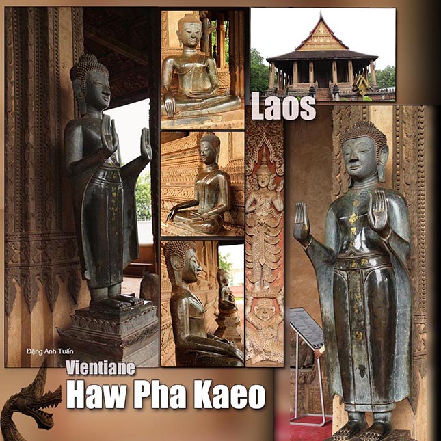
After the disappearance of this kingdom and that of Âu Lạc, the Proto-Thaï remaining in Vietnam at this time under the bosom of Zhao To (a former general of Tsin dynasty who later became the first emperor of Nan Yue kingdom) had their descendants forming properly today the ethnic minority Tày of Vietnam. Other Proto-Thaï fled to Yunnan where they united at the eighth century in Nanzhao kingdom (Nam Chiếu) then Dali (Đại Lý) where buddhism of Greater Vehicle began to take root. Unfortunaly, their attempt was in vain. Shu, Ba, Si Ngeou, Âu Lạc (5), Nan Zhao, Dali countries are part of the list of kingdoms annexed one after the other by the Chinese during their exodus. In these countries submitted, the Proto-Thaïs presence was very important. In front of the Chinese continous pressure and the Himalaya inexorable barrier, the Proto-Thaï had to get back in the Indochinese peninsular (4) by penetrating slowly like a fan in Laos, northwest region of Vietnam (Tây Bắc), northern Thailand and Upper Burma.

According to Thai historical inscriptions found in Vietnam, there are three important waves of migration initiated by the Thai of Yunnan in northwest of Vietnam during the 9th and 11th centuries. This corresponds exactly to the period where Nanzhao was annexed by Dali destroyed, in turn, three centuries later by Kubilai Khan Mongols in China. During this penetration, the Proto-Thaïs were separated into groups: the Thaï of Vietnam, the Thaï in Burma (or Shans), the Thaï in Laos (or Ai Lao in Vietnamese) and the Thaï in Northern Thailand. Each of these groups began to adopt the religion of these host countries. The Thaï of Vietnam do not have the same religion as those of other territories. They continue to keep animism (vạn vật hữu linh) or totemism.

This is not the case of the Thaï living in Northern Thailand, Upper Burma, Laos which were occupied at this time by Indianized and Buddhist theravàda Môn-Khmer kingdoms (Angkorian empire, Môn Dvaravati, Haripunchai, Lavo kingdoms etc …) after the dislocation of Indianized Funan kingdom. The Môn had a key rôle in the transmission of Theravadà Buddhism from Sinhalese tradition for Thai newcomers.


(1): Pays des pandas. C’est aussi ici qu’on a découvert la culture de Ba-Shu célèbre pour ses masques zoomorphes de Sanxingdui et pour le mystère des signes sur les armures. C’est aussi le royaume de Shu-Han (Thục Hán) de Liu Bei (Lưu Bị) à l’époque des Trois Royaumes.(Tam Quốc)

(2) Race de l’Asie du Sud-Est préhistorique.

(3): Comment s’est peuplé le Siam, ce qu’est aujourd’hui sa population. Alfred Raquez, (publié en 1903 dans le Bulletin du Comité de l’Asie Française). In: Aséanie 1, 1998. pp. 161-181.

(4) Indochina in wider sense. This is not French Indochina.

(5) The Âu Lạc kingdom of An Dương Vương was annexed by Chinese General Zhao To (Triệu Đà) who later became the founder of Nanyue kingdom. This one will be in turn under the control of Han dynasty, half a century later.


Bibliography

Ta Prohm (Temple-monastery)

French version

                                                                                                  Great king Jayavarman VII

taprohm

Unlike most of the temples of Angkor, Ta Prohm was left in a state of ruin. It was deliberately chosen by the École française d’Extrême-Orient (French School of Oriental Studies) as an example of what the temples of Angkor looked like at the time of their discovery in the XIXth century. For building this temple, the sovereign Jayavarman VII relied upon the income which the rice culture gave him. The money did not exist at that time. The currency of exchange remained the rice, the basic food of the workers enlisted to build the temple. We find in the Ta Prohm site an inscription indicating that 12 640 people served in this single temple.

It also reports that more than 66 000 farmers produced more than 2 500 tons of rice a year to feed the multitude of priests, dancers and workers in the temple. Because of its romantic attraction, the Ta Prohm temple was selected in the American movie Tomb Raider with Lara Croft (Angela Joli).

Đền – Tu viện Ta Prohm


It is here that the nature took back her rights. Certain walls of the Ta Prohm site can only stand up thanks to the roots of fig and cheese trees who enclose them as huge octopuses. Ta Prohm is considered as one of the temples the most appreciated in Angkor. It was built by great king builder Jaravarman VII at the end of the XIIth century. It was dedicated to his mother because we find the surprising resemblance of this one in the statue of the main divinity in this temple, Prajnaparamita (Perfection of the wisdom). His father was not either forgotten because Lokeçvara, the main god of Preah Khan looks like him enormously.