Version française
Version anglaise
Galerie des photos
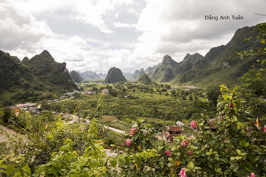
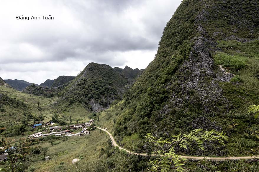
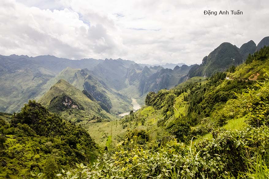
Nằm ở vùng núi phía Bắc Vietnam, Hà Giang là một tỉnh có nhiều núi rừng, giáp ranh giới vói tỉnh Vân Nam của Trung Quốc. Dân số ở nơi nầy rất thưa, chỉ có khoảng chừng 900.000 người theo điều tra dân số năm 2016. Tuy nhiên chính ở nơi nầy tụ hơp rất nhiều dân tộc thiểu số (22 dân tộc) trong đó đáng kể nhất là người Hmong (hay Miêu) tiếp đó người Tày, người Dao và người Nùng. Đến đây mới thấy được cái đẹp tư nhiên của tạo hóa, cái hùng vĩ của non nước, cái nhọc nhằn, công lao của ông cha ta gìn giữ bờ cõi đất nước trước hiểm họa của người phương bắc. Chính cũng ở nơi nầy mới có cảm xúc nhiều khi lặn lội trèo lên 389 bậc thang ở đỉnh Lũng Cú mà thường được gọi là đỉnh núi Rồng (Long Sơn) (1700 mét), nơi mà danh tướng Lý Thường Kiệt phá Tống bình Chiêm dựng lên lúc ban sơ cây cột cờ để khẳng định chủ quyền Vietnam trên mãnh đất nầy.
Tuy Hà Giang nó rất còn hoang sơ của miền sơn cước nhưng nó có cái gì thiêng liêng mà không thể diễn tả được khi đến với mãnh đất nầy. Tôi còn nhớ trước ngày đi đến, ai cũng khuyên không nên đi vỉ tuần trước đường xá sạt lở vì bão Sơn Tinh. Có thể nguy hiểm cho tánh mạng và có thể hủy đi lịch trình Hà Giang khiến tôi sẻ mất một tuần ở Vietnam nhưng rồi tôi cũng quyết tâm đi cùng các con cháu. Tôi mới có dịp nhìn thấy được nét đẹp của Hà Giang, đến tham quan cao nguyên đá Đồng Văn mà cơ quan UNESCO chín thức công nhận là Công Viên địa chất toàn cầu đầu tiên của Vietnam và thứ hai ở Đông Nam Á sau Langkawi (Mã Lai) vào năm 2010.
Hôm đi, không có gì trở ngại cả, cứ lấy quốc lộ 2 đến Tuyên Quang rồi sau đó đến thành phố Hà Giang nghỉ một đêm ở một khách sạn trong thành phố Hà Giang. Trên đường, có một quán bán nước mía không thấy có ruồi chi cả dù có bã mía rất nhiều trong thùng rác. Thấy vậy tôi, các con cháu và cháu tài xế mới mua uống mỗi người một ly. Hai vợ chồng bán nước mía nầy họ trồng sau vườn các bụi mía. Thât ngon và sạch nhất là ở đất nầy không thấy có ruồi có lẽ tại khí hậu của rừng núi và dân số quá thưa. Lâu lắm rồi mới uống được một ly nước mía trong sạch chớ bao giờ dám uống mỗi lần vê Việtnam.
Chiều đó còn được một cặp vợ chồng bạn con dâu mình mời và đãi một buổi cơm với món ăn đặc trưng ở Hà Giang là lẩu ngựa. Ăn kèm theo rau rừng, mùi vị béo ăn cũng không ngán để làm ấm lại con người khi không gian thời tiết se lạnh hay mưa rỉ rả trong đêm. Sáng sớm mưa vẫn rơi, tụi nầy tiếp tục hành trình đi Đồng Vạc với quốc lộ 4C, mình hơi lo, cứ nhủ thầm trong lòng, cứ sương mù xuống nửa lừng đồi thêm mưa rỉ rả như vầy thì chuyện chụp hình của mình cũng hỏng chưa nói chuyện sạt lở đất ở giữa đường đi, đôi khi có một tảng đá to lớn vài tấn nằm bên hông đường. Không có chỉ dẩn rõ ràng chi cả có đi đuợc hay không, cháu tài xế Minh cứ lẳng lặng lái xe.
Chính nhờ sự bình tĩnh cũa Minh và tính tiền định có ở nơi người con Việt mà sự lo âu của mình cũng dần dần biến mất nhất là có những đọan đường không có mây đen trời lại nắng khiến mình mãi mê chụp hình mà quên tất cả. Nhưng có những đoạn đường quanh co nguy hiểm đến đổi phải sửng sốt đèo nầy qua thì đèo khác tới khiến làm ai cũng mệt nhất là chỉ có tổng cộng hơn 200 cây số mà 6, 7 tiếng đồng hồ phải mất . Mệt thì có mệt nhưng với không gian yên tĩnh, con người hiền hòa của vùng sơn cước thì cũng nên cần có chớ không như ở Saïgon hay Hànội cái ồn ào ầm ĩ của tiếng kèn, cái không gian sôi động không ngừng.
Cũng không có trộm cắp như các đô thị khác theo lời kể của cháu tài xế. Cụ thể là gà, vịt, trâu và bò vẫn ngẩn ngơ do dự từng bước sang ngang trên quốc lộ mà tất cả xe lớn xe nhỏ phải tránh và dù tụi nó xa nhà của chủ nhân có cả cây số. Cũng không ai dám cán chúng nó vì sợ chủ nhân đòi đền gấp nhiều lần hơn. Dọc theo quốc lộ, lúc nào cũng thấy các cánh đồng ngô xanh của dân tộc Hmong. Họ rất giỏi về làm ruộng. Bởi vậy từ thưở nào người Trung Hoa dùng chữ tựơng hình điền 田 thêm trên đầu chữ tượng hình thảo (lúa)艹 ám chỉ nguời Hmong 苗 hay Miêu, những người giỏi về canh tác đấy.
Cũng đúng thôi vì nhìn trên tản đá chỉ cần một tí đất là cây ngô có thể chồi ra dễ dàng. Đôi khi dọc theo đường nhìn sâu qua kiến xe có một hay hai cái nhà của người Hmong nằm cheo leo sườn núi không biết họ xây dưng làm sao và đi thể nào để vào đó.
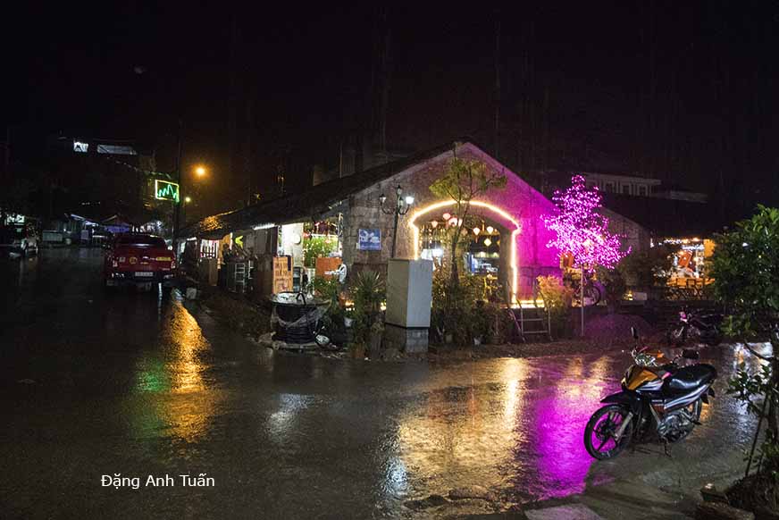
Cũng có phần may mắn khi đến Đồng Văn có một nhà trọ mới sửa ở phố cổ nên tụi nầy được trọ đêm thứ nhì ở đây. Mưa vẫn rơi tầm tã nên đèn đuốc cũng lờ mờ, không có trông đẹp như Hội An, Phố cổ Hànội. Có lẽ tụi nầy đến giữa tuần nên không có nhộn nhịp như lúc cuối tuần. Sáng ngày thứ ba, tụi nầy mới có dịp ăn điểm tâm ở đây, ăn bánh cuốn trứng Đồng Văn, đặc sản ở miền sơn cước.
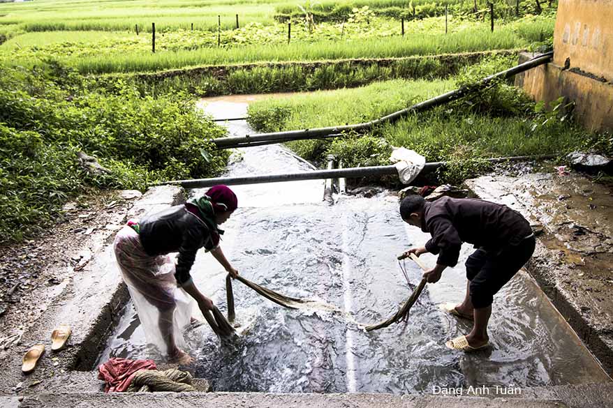
Nó cũng được tráng từ bột gạo và nhân làm từ lợn xay ra, chỉ có khác là thay vì ăn kèm với nước mắm pha chanh đường thì họ dùng với nước hầm (ninh) xương kèm theo hai chiếc giò lụa nhỏ. Mình chỉ thấy có một hương vị đặc biệt nhưng vì có mỡ của xuơng nên ăn dễ ngán lắm. Có lẽ là một cách ăn để ấm lòng và xua đuổi cái lạnh của rừng Tây Bắc cũng như ở Pháp thường ăn bơ với mùa đông. Sau đó tụi nầy đi một vòng ở phố cổ Đồng văn, mới có dịp nhìn thấy được cách thức rửa cây lin mà người Hmong dùng để dệt vãi với nước suối trước khi đi tham quan đỉnh Lũng Cú và nhà vua Mèo Vương Chính Đức. Biết bao nhiêu kỷ niệm khó quên và cảm xúc không ít với ba ngày ở Hà Giang nhất là có các con cháu bên cạnh, lúc nào cũng trơ lực trong chuyến đi nầy từ Hà Giang đến Cà Mau, hai cái mốc của đất nước cách xa 1535 cây số.
Située dans la région montagneuse du Nord Vietnam, Hà Giang est une province partageant la frontière commune avec la contrée du sud-ouest de la Chine, Yunnan. Sa population est peu dense et estimée à peu près de 900.000 habitants selon la statistique démographique en 2016. Pourtant c’est une région où il y a la concentration importante des ethnies minoritaires du Vietnam (22 ethnies) parmi lesquelles il faut citer d’abord les Hmongs suivis par les Tày, les Dao et les Nùng. C’est ici qu’on découvre la beauté extraordinaire du Créateur, la nature grandiose et magnifique du Vietnam fascinant, le labeur et le mérite de nos ancêtres dans l’action de résister à la menace des gens du Nord. C’est ici seulement qu’on ressent une émotion intense lorsqu’on grimpe les 389 marches de l’escalier en pierre de la colline Lũng Cú qu’on est habitué à appeler la « colline du Dragon » à 1700 mètres d’altitude. C’est ici aussi que le général vainqueur des Song et pacificateur du Chămpa Lý Thường Kiệt a édifié au début un mât en bois de quelques mètres pour affirmer avec intransigeance la souveraineté du Vietnam sur ce territoire.
Bien que ce dernier ait l’air d’une région montagneuse sauvage et difficilement pénétrable, il y a quelque chose sacrée que je n’arrive pas à décrire en venant ici. Je rappelle bien que la veille de mon départ, tout le monde m’a recommandé d’abandonner le projet de visiter Hà Giang car elle a été dévastée la semaine précédente par la tempête « Sơn Tinh« . Cela pourrait provoquer des ennuis pour moi et me faire perdre une semaine de vacances au Vietnam. Malgré cela, je continue à persister dans le dessein d’y aller. J’ai ainsi l’occasion d’admirer le charme irrésistible de Hà Giang et de visiter le plateau karstique Đồng Văn que la fondation UNESCO a reconnu comme le deuxième parc géologique de l’Asie du Sud Est après celui de la Malaisie (Langkawi) en 2010.
Nous n’avons aucun souci le jour du départ. Nous n’avons qu’à prendre la route nationale n°2 pour aller à la ville Tuyên Quang avant de rejoindre ensuite la ville Hà Giang pour passer la nuit à l’hôtel. Sur la route, nous avons l’occasion de rencontrer un kiosque détenu par un couple et spécialisé dans la vente du jus de canne à sucre. Nous constatons qu’il n’y a pas de mouches aux alentours malgré la présence d’une poubelle remplie de déchets de canne à sucre broyés. Nous pensons que le climat joue un rôle important et la démographie n’est pas importante. Nous sommes tentés, chacun de prendre un verre de jus de canne à sucre. C’est extrêmement délicieux car jusqu’à ce jour je n’ose pas à le prendre quand je reviens au Vietnam.
Le soir même, nous sommes invités par un couple d’amis de ma belle-fille Oanh dans un restaurant connu pour sa spécialité locale (lẫu ngựa)(ou fondue vietnamienne de viande de cheval). Accompagné par les légumes de la région montagneuse, ce plat ayant la saveur grasse ne nous dégoûte pas mais il nous réchauffe tellement lorsque le temps commence à se refroidir et la pluie est sporadique durant toute la nuit. Le lendemain, la pluie continue à tomber toujours. Malgré cela, nous prenons la route nationale 4C en direction de Đồng Văn.
L’inquiétude commence à m’envahir car si le brouillard continue à s’épaissir de plus en plus à mi-hauteur de la colline avec la pluie persistante comme celle de la nuit, l’idée de faire les photos serait tombée à l’eau sans évoquer les dégâts causés sur la route par la dernière tempête ( plusieurs gros bloc de pierre de plusieurs tonnes étant souvent visibles au bord de la route). Aucune indication n’est fournie pour connaître la praticabilité de la route ou non. Notre chauffeur Minh continue à conduire avec assiduité sans être inquiété par l’absence de l’indication.
C’est grâce à son calme et à l’attitude fataliste reçue des Vietnamiens que mon inquiétude s’estompe au fil de la journée. Sur certains tronçons de la route, le retour du soleil m’incite à tout oublier et à me consacrer entièrement à faire des clichés. Par contre il y a des tronçons de route très dangereux et tellement sinueux que cela nous rend tous fatigués. Pour 200 kilomètres de trajet, il faut compter au minimum 6 ou 7 heures de route. Malgré cela, nous sommes contents d’avoir cet espace tranquille et les gens gentils et aimables de la région montagneuse au lieu de retrouver à Saïgon ou à Hanoï le bruit incessant des klaxons et l’espace tellement animé et pollué.
Selon le chauffeur Minh, il n’y a pas non plus le vol comme on le trouve dans les villes. Les poulets, les canards, les buffles ou les bœufs hésitant dans leur marche peinent à traverser la route sans que leur propriétaire s’inquiète de les perdre même s’ils sont loin de leur enclos.
Personne n’aime à les écraser car il faut payer un prix très fort au propriétaire. Sur le bord de la route, on trouve souvent les champs de maïs des Hmong. Ils sont experts dans le domaine de la culture. C’est pourquoi les Chinois se servent depuis longtemps du pictogramme điền 田 (champ) au dessus duquel est ajouté le pictogramme thảo 艹(riz paddy) pour désigner les Hmong 苗 (ou Miêu), les gens doués pour la culture du sol.
C’est ce que nous constatons en découvrant de près sur une roche garnie d’une petite motte de terre l’apparition d’une plante de maïs. Parfois à travers la vitrine de la voiture, nous découvrons au loin une ou deux maisons des Hmong perchées sur le flanc de la montagne. On se demande comment arrivent-ils à les construire et à y accéder?
Nous avons la chance de passer la deuxième nuit à Đồng Văn dans un homestay récemment rénové au centre de la vieille ville. La pluie continue à tomber le soir. C’est pourquoi aucune attraction n’a lieu et les lampions sont clairsemés par rapport à ceux de Hội An et de la vieille ville de Hànội. Du fait que nous sommes arrivés au milieu de la semaine, nous ne trouvons aucune animation organisée fréquemment en fin de la semaine. Le matin du troisième jour, pour prendre le petit déjeuner, nous cherchons de bonne heure un restaurant spécialisé dans la préparation d’une crêpe à l’œuf (bánh cuốn trứng) typique de Đồng Văn.
Étant une spécialité de la région montagneuse, cette crêpe est faite à partir de la farine de riz et de la viande hachée et se déguste en la trempant dans une sauce mijotée à petit feu avec des os de porc et accompagnée toujours par deux petits morceaux de pâté de viande. Ce plat a une saveur particulière mais à cause de la consistance graisseuse de la sauce, il est difficile de renouveler l’envie.
C’est peut-être la façon de se réchauffer et d’évacuer le froid provenant de la forêt Nord-Ouest comme en France on est habitué à manger du beurre en hiver. Nous allons faire ensuite un tour à Đồng Văn. Nous avons l’occasion de voir la façon des Hmongs de laver le lin avant de s’en servir pour le tissage de leurs vêtements avec l’eau de source. Puis nous visitons la colline Lũng Cú et le palais fortifié du roi des Hmongs Vương Chính Đức. J’ai tellement des souvenirs et des moments d’émotion intense qu’il est difficile de remémorer pour ces trois jours de visite à Ha Giang en compagnie de mes enfants et de mon petit-fils qui ne cessent pas de me soutenir dans ce projet depuis le début jusqu’à la fin de ce voyage inoubliable. (de Hà Giang jusqu’à la pointe de Cà Mau, 1535 km à parcourir).
English version
Located in the mountainous region of Northern Vietnam, Hà Giang is a province sharing a common border with the southwestern region of China, Yunnan. Its population is sparse and estimated at about 900,000 inhabitants according to demographic statistics in 2016. Yet, it is a region with a significant concentration of Vietnam’s ethnic minorities (22 ethnic groups), among which the Hmongs are the most notable, followed by the Tày, the Dao, and the Nùng. It is here that one discovers the extraordinary beauty of the Creator, the grand and magnificent nature of fascinating Vietnam, the labor and merit of our ancestors in resisting the threat from the northern people. It is only here that one feels an intense emotion when climbing the 389 steps of the stone staircase on Lũng Cú hill, commonly called the « Dragon Hill, » at an altitude of 1,700 meters. It is also here that the general who defeated the Song and pacified Champa, Lý Thường Kiệt, initially erected a wooden pole a few meters high to firmly assert Vietnam’s sovereignty over this territory.
Although it looks like a wild and hardly accessible mountainous region, there is something sacred that I cannot describe when coming here. I clearly remember that the day before my departure, everyone recommended that I abandon the project of visiting Hà Giang because it had been devastated the previous week by the storm « Sơn Tinh« . This could cause trouble for me and make me lose a week of vacation in Vietnam. Despite this, I continued to persist in the intention to go there. I thus had the opportunity to admire the irresistible charm of Hà Giang and to visit the Đồng Văn karst plateau, which the UNESCO foundation recognized as the second geological park in Southeast Asia after the one in Malaysia (Langkawi) in 2010.
We had no problem on the day of departure. We just had to take national road No. 2 to go to the city of Tuyên Quang before then joining the city of Hà Giang to spend the night at the hotel. On the way, we had the opportunity to encounter a kiosk owned by a couple and specialized in selling sugarcane juice. We noticed that there were no flies around despite the presence of a trash bin filled with crushed sugarcane waste. We think that the climate plays an important role and that the demography is not important. We are each tempted to have a glass of sugarcane juice. It is extremely delicious because until now I have not dared to have it when I return to Vietnam.
That same evening, we are invited by a couple of friends of my daughter-in-law Oanh to a restaurant known for its local specialty (lẫu ngựa) (or Vietnamese horse meat fondue). Accompanied by vegetables from the mountainous region, this dish, with its rich flavor, does not disgust us but warms us up so much as the weather begins to cool and the rain is sporadic throughout the night. The next day, the rain continues to fall. Despite this, we take National Road 4C towards Đồng Văn.
Worry begins to overwhelm me because if the fog continues to thicken more and more halfway up the hill with persistent rain like that of the night, the idea of taking photos would be ruined, not to mention the damage caused to the road by the last storm (several large stone blocks weighing several tons are often visible at the roadside). No indication is provided to know whether the road is passable or not. Our driver Minh continues to drive diligently without being concerned by the lack of signs.
It is thanks to his calm and the fatalistic attitude inherited from the Vietnamese that my anxiety fades throughout the day. On certain stretches of the road, the return of the sun encourages me to forget everything and fully dedicate myself to taking pictures. However, there are very dangerous and winding sections of the road that make us all tired. For 200 kilometers of travel, it takes at least 6 or 7 hours on the road. Despite this, we are happy to have this peaceful space and the kind and friendly people of the mountainous region instead of returning to Saigon or Hanoi with the incessant noise of horns and the very lively and polluted environment.
According to the driver Minh, there is also no theft like what is found in the cities. Chickens, ducks, buffaloes, or oxen hesitating in their walk struggle to cross the road without their owners worrying about losing them even if they are far from their pens. No one likes to run them over because a very high price must be paid to the owner. Along the roadside, you often find the Hmong’s cornfields. They are experts in the field of cultivation. That is why the Chinese have long used the pictogram điền 田 (field) above which is added the pictogram thảo 艹 (rice paddy) to designate the Hmong 苗 (or Miêu), the people skilled in soil cultivation.
This is what we observe when closely discovering, on a rock adorned with a small clump of earth, the appearance of a corn plant. Sometimes, through the car window, we spot one or two Hmong houses perched on the mountainside in the distance. We wonder how they manage to build and access them?
We are fortunate to spend the second night in Đồng Văn at a recently renovated homestay in the center of the old town. The rain continues to fall in the evening. This is why no attractions take place and the lanterns are sparse compared to those in Hội An and the old town of Hà Nội. Since we arrived midweek, we find no frequently organized events at the end of the week. On the morning of the third day, to have breakfast, we early on look for a restaurant specializing in preparing an egg pancake (bánh cuốn trứng) typical of Đồng Văn.
Being a specialty of the mountainous region, this pancake is made from rice flour and minced meat and is enjoyed by dipping it in a sauce simmered slowly with pork bones, always accompanied by two small pieces of meat pâté. This dish has a particular flavor, but due to the greasy consistency of the sauce, it is hard to want to have it again.
It may be a way to warm up and get rid of the cold coming from the Northwest forest, just like in France where we are used to eating butter in winter. Then we will take a tour of Đồng Văn. We have the opportunity to see how the Hmongs wash the flax before using it to weave their clothes with spring water. Then we visit Lũng Cú hill and the fortified palace of the Hmong king Vương Chính Đức. I have so many memories and moments of intense emotion that it is difficult to recall these three days of visiting Ha Giang in the company of my children and my grandson who have continuously supported me in this project from the beginning to the end of this unforgettable journey. (From Hà Giang to the tip of Cà Mau, 1535 km to travel).
Cuộc hành trình Hà Giang theo hình ảnh
Paris 28/08/2018
[RETOUR]

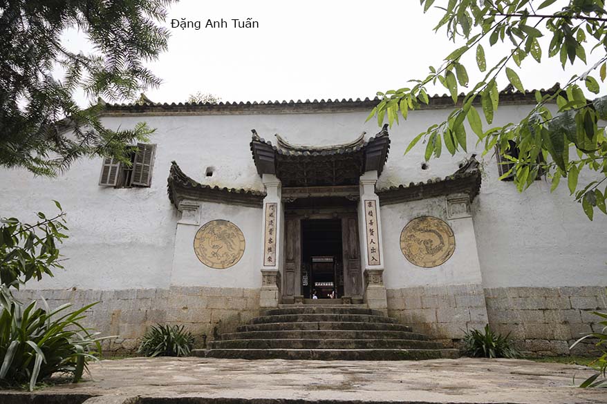
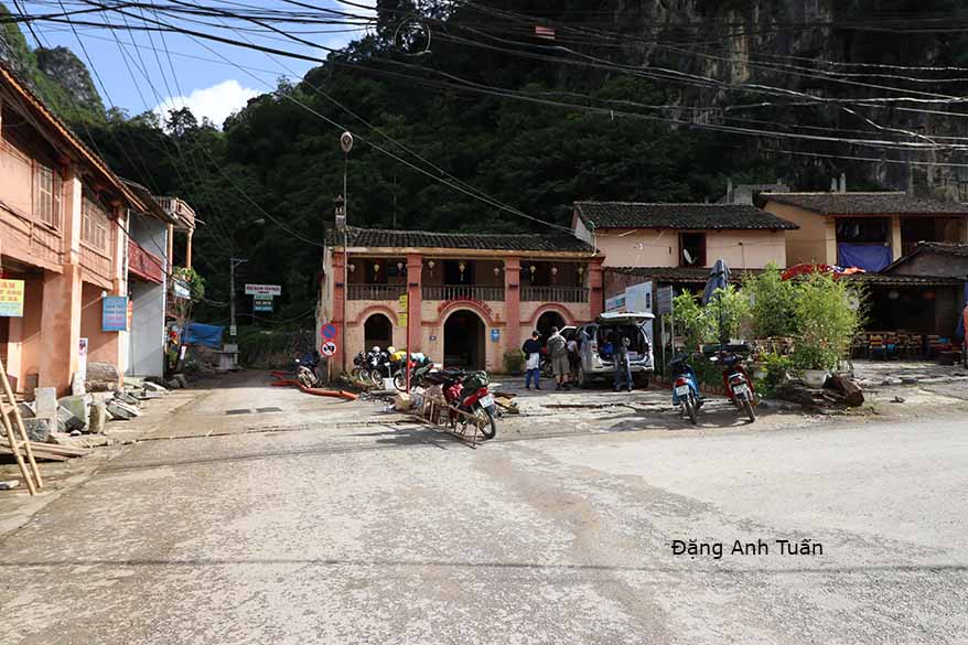
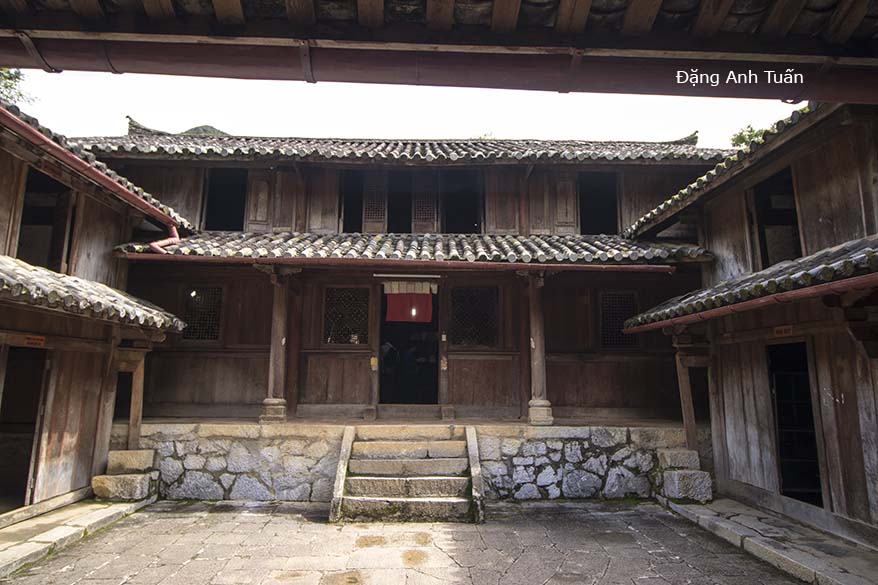 Maison principale avec ses deux dépendances opposées