Non nước Cao Bằng (Monts et Eaux Cao Bằng)

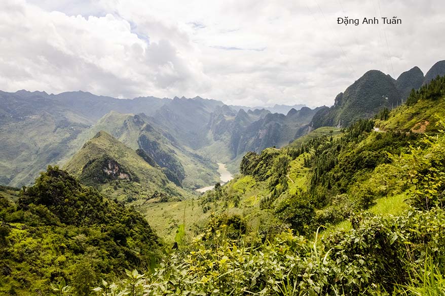
Le fleuve Nho Quế se faufile comme un serpent à travers les montagnes

Version française
English version
Galerie des photos

Sau công viên địa chất Đồng Văn (Hà Giang), Việt Nam đuợc có thêm  công viên địa chất thứ hai  Non nước Cao Bằng gia nhập vào  mạng lưới công viên địa chất toàn cầu  mà tổ chức Liên Hiệp Quốc  UNESCO công nhận vào tháng 4 vừa qua (2018). Tỉnh   Cao Bằng  cùng tên nầy thuộc vùng đông bắc Việt Nam, giáp ranh giới với khu tự trị Quảng Tây của Trung Quốc. Cao Bằng nằm cách xa thủ đô Hànội 286 km.  Đến từ Hà Giang, tụi nầy chọn đi qua con đèo độc đáo Mã Pí Lèng. Đèo nầy nằm giữa cao nguyên Đồng Văn, một bên là vách núi Mã Pí Lèng còn một bên là sông Nho Quế. Đèo nầy  không dài chi cho mấy chỉ khoảng 20 km nhưng nó rất hùng vĩ ngoạn mục nhất ở Việt Nam vì trong tầm mắt trên cao nhìn xuống đèo nó nhỏ  như  sợ chỉ, như con rắn bò qua hàng ngàn núi đá  trọc màu xám trùng trùng điệp điệp lô nhô cây cối.  Đèo nầy được ví như « vua của các đèo » ở Việtnam vì nó rất nguy hiểm với những đoạn cua tay lổn nhổn đá hộc, hai ô tô phải né tránh nhau với tiếng kèn.  Sở dĩ đèo nầy mang cái tên Mã Pí Lèng vì theo tiếng Quảng Đông là sóng mũi con ngựa. Tuy nhiên các người Hmong họ cho là sóng mũi con mèo.

Theo lời kể dân gian, các con ngựa cái leo qua đèo nầy  dễ bị trụy thai vì  dốc nó cao  quá chừng khiến con ngựa đuối sức trèo lên tắc thở.   Đường nầy được mang tên Hạnh Phúc nhưng thật sư đựợc thành hình với mồ hôi, xương máu và nước mắt của đội quân cảm tử thuộc  16 dân tộc thiểu số (Tày, Mèo, Lolo, Pù Péo vân vân …) cùng nhau đục đẽo từng viên đá ngày đêm trong thời gian suốt  6 năm liền. Có thể nói là con đường gian nan khổ sở nhất cho những ai lái xe nhưng nó cũng là một niềm vui không ít cho những người du lịch thích cảnh vật thiên nhiên  hoang dã. Có đến đây mới thành hảo hán vì đây được xem như là Vạn Lý Trường Thành của Việt Nam, có đến đây mới thấy đất nước Việt Nam rất xinh đẹp  và xanh tươi.

Cao Bằng là một tỉnh ít bị ô nhiễm nhất chỉ có khoảng chừng 500.000 dân. Cao Bằng nổi tiếng có thác Bản Giốc, có động Ngườm Ngao, có khu di tích Pắc Bó. Chính ở nơi nầy mà người anh hùng của dân tộc Tầy Nùng, Nùng Trí Cao khởi nghĩa dành độc lập chống lại nhà Tống như tộc Lạc Việt với Ngô Quyền. Mặc dầu việc quật khởi không thành, ông được xem là người anh hùng của dân tộc Choang (Tày Nùng) và được tôn thờ ở Cao Bằng nhất là ở chùa Phật Tích Trúc Lâm Bản Giốc. Chính ở nơi nầy mà theo lời chỉ dẩn của Trạng Trình Nguyễn Bỉnh Khiêm  mà con cháu nhà Mạc chạy về đây cố thủ, làm vua được ba đời thêm vào thế kỷ 16.

Version française 

Après la reconnaissance du parc karstique de Đồng Văn , le Vietnam a eu  récemment le deuxième parc  géologique Non Nước Cao Bằng reconnu comme   membre du Réseau global des parcs géologiques de la part de l’UNESCO en avril dernier (2018). La  province Cao Bằng  est  située au nord-est du Vietnam et a une frontière commune avec la région autonome Kouang Si (Quảng Tây) de la Chine. Elle est distante  de la capitale Hànội de 286 km. En partant de Hà Giang, nous sommes décidés de prendre la route menant au col majestueux Mã Pí Leng. Celui-ci est situé au cœur du plateau calcaire Đồng Văn avec d’un côté les falaises de Mã Pí Leng  et de l’autre  le fleuve Nho Quế. Ce col fait environ 20 km de long mais il est grandiose et  très spectaculaire au Vietnam car à portée de vue en haut, le col  ressemble à un fil mince ou à un serpent se faufilant à travers des milliers de rochers nus et gris qui se succèdent  et se laissent  envahir par la végétation.  Il est considéré comme le « roi des cols »  au Vietnam car il est tellement  dangereux  avec des tronçons de route  en forme de coude  et remplis  de blocs de pierre  équarris en désordre que  le klaxon  des  voitures doit retentir sans cesse pour éviter les risques de collision.

C’est pourquoi ce col porte le nom « Mã Pí Lèng » car selon le cantonais, c’est le bout avant du  nez du cheval. Mais pour les Hmong c’est le bout avant du  nez du chat. Selon l’on-dit,  en prenant ce col, la jument enceinte aurait le risque d’avortement car  la pente est tellement  haute que  le cheval serait mort d’épuisement pour la montée. Cette route sinueuse est appelée souvent  « route du bonheur »  mais elle  a été construite  avec la sueur, le sang et les larmes des volontaires recrutés parmi les  16 ethnies minoritaires  (Tày, Mèo, Lolo, Pù Péo etc.) du Vietnam,  ne cessant pas de travailler jour et nuit durant les six années consécutives  pour cette réalisation titanesque. 

On peut dire que c’est la route la plus difficile pour les chauffeurs. En passant par ce col, on se sent fier d’être un brave car on le  considère comme la Muraille de Chine du Vietnam. C’est aussi une  joie immense pour les touristes, en particulier pour ceux qui aiment la nature sauvage. En venant ici, on s’aperçoit que le Vietnam est un très beau pays et qu(il il est incroyablement vert.

La province Cao Bằng est la moins polluée car elle n’a qu’à peu près 500.000 habitants. Cao Bằng est connue pour ses chutes d’eau Bản Giốc, sa grotte Nguờm Ngao,  le site historique Pắc Bó. C’est ici que le héros national du peuple Choang Nùng Trí Cao a tenté le soulèvement populaire  contre les Song (Chinois) pour établir un royaume Đại Nam au sud de la Chine comme les Vietnamiens avec le général Ngô Quyền.  Malgré l’échec de ce soulèvement, il est considéré comme un héros du peuple  Choang et vénéré partout à Cao Bằng, en particulier à la pagode Phật Tích en face des chutes d’eau Bản Giốc. C’est ici que sur les recommandations du Nostradamus vietnamien Nguyễn Bỉnh Khiêm que les descendants de la dynastie des Mạc se réfugièrent  au 16ème  siècle pour se défendre et maintenir encore leur règne pour trois générations.

English version

After the recognition of the Đồng Văn Karst Park, Vietnam recently had the second Non Nước Cao Bằng Geological Park recognized as a member of the Global Network of Geological Parks by UNESCO last April (2018). Cao Bằng Province is located in the northeast of Vietnam and shares a border with the Kouang Si (Quảng Tây) Autonomous Region of China. It is 286 km from the capital Hanoi. Leaving Hà Giang, we decided to take the road leading to the majestic Mã Pí Leng Pass. This is located in the heart of the Đồng Văn limestone plateau with the cliffs of Mã Pí Leng on one side and the Nho Quế River on the other.

This pass is about 20 km long but it is grandiose and very spectacular in Vietnam because from the top, the pass looks like a thin thread or a snake winding through thousands of bare and gray rocks that follow one another and are invaded by vegetation. It is considered the « king of passes » in Vietnam because it is so dangerous with sections of road in the shape of an elbow and filled with disorderly squared stone blocks that the car horns must sound constantly to avoid the risk of collision. This is why this pass is called « Mã Pí Lèng » because according to Cantonese, it is the front tip of the horse’s nose. But for the Hmong it is the front tip of the cat’s nose. According to the saying, when passing through this pass, the pregnant mare would have the risk of abortion or the slope is so steep that the horse would die of exhaustion while climbing it. This winding road is often called « road of happiness » but it was built with the sweat, blood and tears of volunteers recruited from the 16 ethnic minorities (Tày, Mèo, Lolo, Pù Péo etc.) of Vietnam, who did not stop working day and night for six consecutive years for this titanic achievement.

One can say that this is the most difficult road for drivers. Passing through this pass, one feels proud to be brave because this pass is considered the Great Wall of China of Vietnam. It is also a great joy for tourists, especially those who love wild nature. Coming here, one realizes that Vietnam is a very beautiful country and incredibly green.

Cao Bằng province is the least polluted because it has only about 500,000 inhabitants. Cao Bằng is known for its Bản Giốc waterfalls, Nguờm Ngao cave, and the historical site Pắc Bó. It is here that the national hero of the Choang Nùng people, Trí Cao, attempted a popular uprising against the Song (Chinese) to establish a Đại Nam kingdom south of China, like the Vietnamese with General Ngô Quyền. Despite the failure of this uprising, he is considered a hero of the Choang people and is venerated everywhere in Cao Bằng, especially at the Phật Tích pagoda opposite the Bản Giốc waterfalls. It is here, on the recommendations of the Vietnamese Nostradamus Nguyễn Bỉnh Khiêm, that the descendants of the Mạc dynasty took refuge in the 16th century to defend themselves and maintain their rule for three more generations.

Galerie des photos (de Hà Giang à Cao Bằng)


La bourgade de Đồng Văn (Phố cổ Đồng Văn)

Version française
Version anglaise
Galerie des photos

Nằm ở giữa lòng thung lũng của cao nguyên đá Đồng Văn, phố nầy lúc ban đầu có khoảng chừng 40  cái nhà mà thôi. Khu phố nầy được thành hình vào đầu  thế kỷ 20 dưới chân núi  với vài gia đình người Hmong, người Tày và người Hoa. Bởi vì được xây cất với các thợ  được thuê đến từ Tứ Xuyên nên các nhà ở đây mang dấu ấn  khá  sâu đậm của người Hoa qua lối kiến trúc hai tầng trình tường, mái  ngói âm dương và trước cửa nhà có đèn lồng treo cao. Nay trở thành một địa điểm quan trọng mà du khách không thể bỏ qua được khi đến Hà Giang. Nhà cửa ở đây cũng xây cất lại, nhà trọ cũng có nhiều, giá cả cũng  phải chẵn, du khách ngoại quốc nhất là dân đi phượt cũng đông cuối tuần và thích ngủ nhà sàn.

Rất tiếc chiều hôm đó, mưa quá to nên chụp hình không được nhiều. Chỉ sáng hôm sau, trời lại nắng nên mới có vài tấm ảnh để lưu niệm nhưng cũng có dịp viếng thăm một nhà cổ của người Hmong nay thành nhà trọ và có dịp chứng kiến cách thức dùng nước suối rửa cây linh (lin)  trước khi dệt vãi.  Đi miền núi như mình rất mệt nhưng  học hỏi rất nhiều về tập quán nhất là Hà Giang có đến 22 dân tộc thiểu số  và rất thích thú trong cuộc hành trình nầy. 

Située au cœur de la vallée du plateau karstique de Đồng Văn, cette bourgade avait  seulement au moment de sa construction  une quarantaine de maisons.  Elle prit forme au début  du XXème siècle au pied des montagnes rocheuses avec quelques familles Hmong, Tày et Hoa (ou Chinois).  Comme ses maisons ont été construites par des ouvriers recrutés  venant de Sichuan, cette bourgade continue à garder  une  profonde empreinte chinoise à travers son architecture typique à deux étages, son toit avec des tuiles tubulaires âm dương (Yin-Yang) et ses lampions suspendus devant l’entrée.

Aujourd’hui, elle devient un passage obligatoire pour ceux qui visitent Hà Giang.  La plupart de ses maisons sont rénovées et ses « homestay » (logement chez l’habitant) sont nombreux avec un prix assez raisonnable. Les touristes étrangers  sont en majorité des routards ou des gens aimant l’aventure de l’extrême et préférant dormir dans des maisons sur pilotis   et ils sont nombreux à la fin de la semaine.   

C’est regrettable pour nous d’avoir la pluie torrentielle le soir de notre arrivée. C’est seulement le lendemain avec le retour du soleil que je peux faire quelques photos ci-dessus. J’ai aussi l’occasion de visiter une vieille maison devenant aujourd’hui un  « logement chez l’habitant » et d’apprendre la façon de laver le lin avec l’eau de source  avant le tissage des vêtements pratiqué par les Hmong.  L’excursion à la montagne est épuisante   mais elle me permet d’avoir des choses à apprendre en particulier les coutumes et les traditions lorsque la région Hà Giang a 22 minorités ethniques. Je suis très content de ce voyage mémorable. 

La bourgade Đồng Văn au fil de la nuit.

Laver le lin avant le tissage des vêtements par les Hmong.

Located in the heart of the Đồng Văn karst plateau valley, this small town had only about forty houses at the time of its construction. It took shape at the beginning of the 20th century at the foot of the rocky mountains with some Hmong, Tày, and Hoa (or Chinese) families. Since its houses were built by workers recruited from Sichuan, this town continues to retain a strong Chinese influence through its typical two-story architecture, its roof with âm dương (Yin-Yang) tubular tiles, and its lanterns hanging in front of the entrance. Today, it has become a must-visit stop for those visiting Hà Giang. Most of its houses have been renovated, and its homestays are numerous with quite reasonable prices. The majority of foreign tourists are backpackers or people who love extreme adventure and prefer to sleep in stilt houses, and many of them come at the end of the week.

It is unfortunate for us to have torrential rain on the evening of our arrival. It is only the next day, with the return of the sun, that I can take some photos above. I also had the opportunity to visit an old house that has now become a « homestay » and to learn how to wash flax with spring water before weaving clothes, a practice of the Hmong. The mountain excursion is exhausting, but it allows me to learn many things, especially the customs and traditions since the Hà Giang region has 22 ethnic minorities. I am very happy with this memorable trip.


bourgade_dong_van

[RETOUR]

Eglise Notre Dame de Paris (Nhà thờ Đức Bà Paris)


Version française

Notre Dame de Paris

Version française

Version anglaise

Từ một nhà thờ nhỏ bé với phong cách xưa (romane) mà đến phong cách gothique thì có một đoạn đường khá dải hơn hai thế kỷ từ  1160 đến giữa thế kỷ 14, có nhiều sửa chữa và bổ túc khiến nhà thờ nầy trở thành một kiệc tác của Paris mà không ai có thể quên khi đến tham quan Paris. Số lượng người đi xem  là 13 triệu người mỗi năm có nghĩa là hơn 30.000 du khách mỗi ngày. Nó luôn luôn đứng đầu trong danh sách các nơi tham quan ở Paris, trước tháp Eiffel  và điện Louvre. Nhà thờ nầy là một trong những nhà thờ xây dựng đầu tiên  với phong cách gothique. Phong cách nầy dựa trên các vòm mà có ở các nơi bắt tréo hình nhọn  và gân cung. Nhờ vậy trọng lượng của vòm nó không dựa trên hai trụ mà 4 trụ. Phong cách nầy đem lại không những sự  sáng sủa nhờ có nhiều cửa sổ mà còn cao vút tạo ra sự tao nhã lạ thường. Tại sao gọi gothique ? Thuật ngữ gothique dùng  bởi người La Mã để ám chỉ dân  Goth, dân mọi rợ đến từ phiá  Bắc (người Pháp thưở xưa). Nhà thờ Đức Bà được  sùng tu lại sau khi bi hỏa hoạn xảy ra vào ngày 15 Tháng tư 2019 và mở lại cho dân chúng từ cuối năm 2024. 

Partant d’une église romane jusqu’à devenir une église gothique, il y a un long chemin à parcourir prenant plus de deux siècles, de 1160 jusqu’au milieu du 14ème  siècle.  Beaucoup de modifications et d’ajouts étant ajoutés, elle devient ainsi un chef-d’œuvre de Paris que personne ne peut oublier  lors de son passage à Paris. Le nombre de visiteurs s’élève à 13 millions par an ou plus 30.000 touristes par jour.  Elle est toujours la première sur la liste des sites touristiques à Paris devant la tour Eiffel et le musée du Louvre. 

Cette église est l’une des premières églises construites avec le style gothique. Celui-ci est basé essentiellement sur la technique de la voûte sur croisée d’ogive  (ses arcs brisés se croisent en  diagonales et s’appuient non pas sur deux piliers mais sur quatre piliers). Cette technique apporte non seulement la lumière grâce à un nombre élevé de fenêtres (vitraux)  mais aussi l’élévation et la finesse extraordinaire. Pourquoi gothique ? Ce mot est employé par les Romains pour faire allusion à des Goths,  des peuplades barbares situées dans le Nord de l’Europe (les Français d’autrefois). Notre Dame de Paris à Paris est restauré cause d’une incendie ayant eu lieu le 15 Avril 2019 et est réouvert au public à la fin de l’année 2024. 


Galerie des photos


Notre Dame de Paris


[RETOUR]

Passages couverts de Paris (Các hành lang cổ kính của Ba Lê)

Passage Colbert

Version vietnamienne

Méconnus jusqu’à une date récente, les passages de Paris redeviennent aujourd’hui l’un des attraits touristiques et architecturaux de Paris. Dans les années 1850, Paris possède au moins 150 passages couverts et exporte le modèle vers d’autres villes françaises (Bordeaux, Nantes etc.) et vers l’étranger (Italie, Turquie, Grande-Bretagne etc.). C’est aussi  un modèle importé de Paris, le passage Eden dans lequel on était habitué à flâner à Saïgon (Vietnam) dans les années 1970.  Ces passages parisiens se regroupent sur la rive droite de la Seine, en particulier dans le quartier des Grands Boulevards. Plusieurs passages ont été démolis au profit de l’urbanisation entamée par les grands travaux du baron Haussman et de l’essor de grands magasins ( Le Bon Marché, la Samaritaine, le Printemps etc.). Il ne reste qu’une vingtaine de passages aujourd’hui à Paris. Ils font partie désormais du patrimoine architectural et mémoriel de la capitale.

Một cuộc du ngoạn thú vị ở Paris
qua các hành lang


Les passages couverts  de Paris

  • Passage  Choiseul  (Rue Saint Augustin)
  • Passage Colbert (Rue des Petits Champs)
  • Passage Vivienne (Rue Vivienne)
  • Passage des Panoramas ( Boulevard Montmartre)
  • Passage Jouffroy (Boulevard Montmartre)
  • Passage des princes (Boulevard des Italiens) 
  • Passage du Grand-Cerf ( Rue du Saint Denis ) 
  • Passage Brady ( Rue du Faubourg Saint Denis) 
  • Passage Verdeau (rue de la Grange-Batelière) etc.
Passages_couverts-2

Version vietnamienne

Ít được biết đến trong thời gian qua, các hành lang của Paris trở lại hiên nay là một trong những nơi thu hút du khách ngoại quốc khi đến Paris. Trong những năm 1850, Paris có ít nhất 150 hành lang bao phủ và xuất khẩu mô hình nầy qua nhiều thành phố khác của Pháp như (Bordeaux, Nantes vân vân …) và các nước ngoài như Ý Đại Lợi, Thổ Nhi Kỳ, Anh Quốc vân vân….  Cũng với mô hình nầy mà hành lang Eden được xây cất có một trăm năm và người Saïgon có dip đến đây du ngoạn trong thập niên 70. Các hành lang Paris nầy được tập trung ở hữu ngạn của sông Seine, nhất là trong khu vực được gọi là « Les Grands Boulevards ». Nhiều hành lang bị phá hủy sau nầy trong việc thực hiện các công trình đồ sộ của bá tước Haussman và đáp lại sự phát triển của các cửa hàng lớn như Le Bon Marché, la Samaritaine, le Printemps vân vân … Nay chỉ còn lại khoảng chừng 20 hành lang ở Paris. Các hành lang nầy đươc xem hiện nay là di sản kiến trúc và lưu niệm của thành phố Paris.

Pyramide du Louvre (Kim tự tháp kính Louvre)


La pyramide du Louvre au milieu de la cour Napoléon du musée Louvre

Version française

Version anglaise

Theo lời yêu cầu của cố tổng thống Pháp François Mitterand vào năm 1983, kim tự tháp kính  Louvre được xây bằng kính và kim loại ở giữa sân Napoléon của bảo tàng Louvre. Đây là tác phẩm của kiến trúc sư người Mỹ gốc Hoa , ông Ieoh Ming người được nhận nhiều giải mà  trong đó có giải Pritzkert thường đựợc xem là giải Nobel về kiến trúc. Khi kiến ​​trúc sư Ieoh Ming thiết kế kim tự tháp Louvre, ông đã thiết kế nó theo cùng tỷ lệ với kim tự tháp Kheops. Kim tự tháp kính Louvre có bề cao là  21,64 thước với đáy  hình vuông  mỗi cạnh là 35,42 thước. Toàn bộ kim tự tháp được xây bằng kính cùng các khớp nối bằng kim loại , gồm có tất cả là  603 tấm kính hình thoi (losange)   và 70 tấm hình tam giác (triangle). Lúc đầu kim tự tháp là môt đề tài tranh luận sôi nổi vì  có người cho rằng không phù hợp với khung cảnh cổ kính của cung điện Louvre nhất là  với  phong cách vị lai. Nhưng cuối cùng sự kết hợp của hai phong cách kiến trúc cổ đại và hiện đại nó đem lại không những một kết quả mỹ mãn mà còn đem lại một nét đẹp độc nhất ở giữa thành phố Paris, một viên kim cương hoàn hảo của điện Louvre . Kim tự tháp kính  Louvre trở thành hiện nay một trong những  biểu tượng tham quan không thể thiếu xót cùng tháp Eiffel và nhà thờ Notre Dame de Paris khi ai có dịp đến tham quan Paris.

pyramide

Version française

À la demande du feu président français François Mitterand en 1983, la pyramide du Louvre a été conçue et réalisée en verre et en acier au milieu de la cour  Napoléon du musée Louvre. C’est l’œuvre de l’architecte américain d’origine chinoise  Ieoh Ming  ayant reçu plusieurs prix parmi lesquels figure le prix d’architecture Pritzker considéré jusqu’alors comme le prix Nobel de l’architecture.  Quand l’architecte Ieoh Ming imagine la pyramide du Louvre, il lui donne les mêmes proportions que celles du Kheops. La pyramide du Louvre s’élève à 21,64 mètres sur une base  carrée  de 35,42 mètres de côté. Étant réalisé  avec une structure métallique en acier et en aluminium, le tout de la pyramide comporte 603 losanges et 70 triangles en verre. Au début de sa construction, la pyramide du Louvre est l’objet d’âpres  controverses  car selon certains, la pyramide est mal incorporée  dans le classicisme du palais Louvre avec un style futuriste. Mais finalement l’association de deux styles d’architecture classique et futuriste apporte non seulement un franc succès mais aussi un charme unique au cœur de la ville de Paris, un joyau d’architecture  parfait du palais Louvre.  La pyramide du Louvre devient aujourd’hui l’une des attractions touristiques qu’il est impossible de manquer avec la tour d’Eiffel et l’église  Notre Dame lorsqu’on a l’occasion de visiter Paris. (8,9 millions en 2011).

Version anglaise

At the request of the late French President François Mitterand in 1983, the Louvre Pyramid was designed and built in glass and steel in the middle of the Louvre’s Cour Napoléon. It is the work of Chinese-born American architect Ieoh Ming, whose many awards include the Pritzker Architecture Prize, considered until then to be the Nobel Prize for architecture. When Ieoh Ming designed the Louvre pyramid, he gave it the same proportions as those of Kheops. The Louvre pyramid rises to a height of 21.64 meters on a square base measuring 35.42 meters on each side. Constructed from a steel and aluminum structure, the pyramid features 603 rhombuses and 70 glass triangles. At the start of its construction, the Louvre Pyramid was the subject of bitter controversy, as some felt that the pyramid was poorly incorporated into the classicism of the Louvre Palace with its futuristic style. But in the end, the combination of classical and futuristic architectural styles not only proved a resounding success, it also added a unique charm to the heart of Paris, making the Louvre Palace a perfect architectural gem. Today, the Louvre Pyramid is one of the must-see tourist attractions, along with the Eiffel Tower and Notre Dame Church, when visiting Paris (8.9 million in 2011).


Un instant pour soi dans le vieux quartier de Hànội

Một lúc thư thản ở phố cổ Hànội


Le lac Hồ Hoàn Kiếm


un instant pour soi

One moment to myself in the old quarter of Hànội

Mandarin road (English version)

Version française

Mandarin road

If a tourist has a chance to travel by car from Saigon to Hanoï, he has got to take the « mandarin route » (or route No.1 ) as it is the only one that exists on the road network in Vietnam. We owe the name of « mandarin route » to the French who named it in 19th century because it is certain that it was the road taken by mandarins and high functionaries to travel rapidly and easily between the capital and their provinces. This route is born in the swamps of  Mekong delta infested with mosquitoes. It begins at Cà Mau and ends at the post of Ðồng Ðằng on the Sino-Vietnamese border in the region close to Lạng Sơn. It is often said that this route is the country’s backbone that looks like a sea horse. This route is 1730km long, linking several cities, in particular Saigòn, Phan Thiết, Nha Trang, Qui Nhơn, Hội An, Ðà Nẵng, Huế, Ðồng Hới, Hà Tịnh, Thanh Hóa and Hanoï.

It is generally covered with asphalt, but often on some sections, it was badly paved and weighed down by a multitude of trucks, bicycles, pedestrians, buffaloes, cows, and troops of ducks walking on. The bitumen often breaks, causing the grandmother perching side-saddle on the baggage carrier and girls leaning on too big bikes, to jump. Those are the familiar scenes often encountered on this road.

One also finds harvested rice and manioc left to dry on asphalt heated by the sun in the North. On this route, one can see on a side of Sa Huynh, the salt fields or mounds of salt recovered from the foliage and set up alongside of the road. The further one goes north, the more one sees peaceful landscapes of flooded rice paddies.

One often crosses children leading herds of buffaloes daubed with mud. At the edge of Hoa Lư, the ancient capital of Viet Nam, silhouettes of rocky hills emerge from the bluish mist.

Despite its bad condition especially in North Vietnam, it continues to be the axle road vital to Vietnam. For those who like to know the history of Vietnam, the history of the long march towards the South, it is suggested that this route be borrowed because one would find not only the vestiges of a lost civilization in the whirlwind of history, the kingdom of Champa, but also the marks and traces that Vietnamese settlers, for the past decades, succeeded in carving during their passage.

Pictures gallery

Quốc lộ số 1

To know this route is to know not only the immense rice paddies, rubber tree plantations, beautiful sightseeing points on the coast of Vietnam, very beautiful panoramic views from one delta to another, superbs passes (in particular the Hải Vân pass) and wooded hills, almost desolate waste lands, but also an intensity of a Vietnamese agricultural life through hamlets located alongside of the route.

To know this route is to also know the Hiền Lương bridge. It was built by the French in 1950, destroyed by an American airplane in 1967, 178 meters long. It certainly evokes an episode when Viet Nam was divided and when one-half of the bridge was painted red and the other half yellow. It is located at the 17th parallel, in a zone where one of its sections, known during the Indochina war as « the Road without Joy » as French troops encountered fierce resistence there.

To know this route is to know the Hải Vân pass. It is located at 28km north of Ðà Nẫng ( or Tourane ) and only 495m high. As its name indicates, it is always in the clouds because it is close to the sea, which allows it to receive important masses of humid air. In the old days, it marked the frontier between the North and the South and protected the Chams from the Vietnamese appetite for land.

Composer Phạm Duy has evoked this route through his work entitled « Con Ðường Cái Quan« .


Route mandarine (Version française)


Version française

English version

Con đường cái Quan

Nếu du khách có cơ hội đi từ Sài Gòn đến Hà Nội bằng ô tô thì bắt buộc phải đi « con đường cái quan » (hoặc Quốc Lộ số 1) vì đây là tuyến đường duy nhất ở Việt Nam. Tên này có tên là « con đường của các quan » mà người Pháp gọi nó như vậy  bởi vì đây là tuyến đường trước đó được các quan lại và các quan chức cao cấp dùng để đi nhanh chóng dễ dàng giữa thủ đô và các tỉnh. Con đường này được sinh ra ở vùng đầm lầy của đồng bằng sông Cửu Long, đầy dãy các muỗi truyền nhiễm. Nó được bắt đầu ở  Cà Mau và kết thúc tại đồn Đồng Đăng ở biên giới Trung-Việt gần vùng Lạng Sơn. Nó thường được xem là cột sống của đất nước trông nhìn như hồi hải mã (cá ngựa). Con đường này dài đến 1.730 cây số, nối liền một số thành phố, đặc biệt là Cà Mau, Bạc Liêu, Cần Thơ, Vĩnh Long, Sài Gòn (hay thành phố Hồ Chí Minh), Phan Thiết, Nha Trang, Quy Nhơn, Hội An, Đà Nẵng, Huế, Đồng Hới, Hà Tĩnh, Thanh Hóa, Ninh Bình, Hà Nội, Lạng Sơn.

Con đường nầy thường được trán nhựa nhưng trải nhựa rất kém thường bị tắc nghẽn trên vài đoạn đường với một số xe vận tải, xe đạp, các người đi bộ,  các đàn trâu, bò và các đàn vịt chạy lon ton. Nhựa đường hay thường bị nổ vỡ, làm cho bà cụ giật mình gác hai chân trên giá hành lý và những đứa trẻ ngồi trên những chiếc xe đạp quá lớn. Đây là những cảnh tượng bất thường hay gặp trên tuyến đường này.

Ngoài ra còn có những mớ lúa hoặc sắn thu thập còn đang phơi khô trên các đường nhựa nung dưới ánh mặt trời ở miền Bắc. Trên con đường này, chúng ta  có thể nhìn thấy ở phía Sa Huỳnh, các đầm lầy muối hoặc những ụ muối phủ đầy một lớp lá và  được dựng theo dọc đường. Càng đi xa về phía bắc, chúng ta càng có được những quan cảnh  yên bình của những cánh đồng lúa ngập nước. Chúng ta thường bắt gặp những đứa trẻ dẫn đầu đàn trâu dính bùn. Ở ngoại ô Hoa Lư, cố đô của Việt Nam, các hình bóng của những ngọn đồi núi đá vôi xuất hiện trong sương mù.Mặc dù tình trạng đường xá rất tồi tệ nhất là ở miền Bắc Việt Nam, nó vẫn tiếp tục là trục đường quan trọng của Việt Nam. Đối với những người thích tìm hiểu về lịch sử Việt Nam, lịch sữ của cuộc Nam tiến, chúng ta  cần nên đi theo con đường này bởi vì chúng ta không chỉ thấy  các di tích của một nền văn minh bị biến mất trong cơn lốc lịch sử, vương quốc Champa mà  còn cả dấu ấn và dấu vết của  những người định cư Việt Nam qua nhiều thập kỷ mà họ  cố gắng áp đặt trong suốt thời gian họ đi qua. Biết con đường này là không chỉ biết đến những cánh đồng lúa mênh mông, những đồn điền cao su, những góc nhìn tuyệt đẹp dọc theo bờ biển Việt Nam, những toàn cảnh tuyệt vời từ đồng bằng này sang đồng bằng khác, các đèo vô cùng ngoạn mục  đặc biệt là đèo Hải Vân, những ngọn đồi rừng rậm, những cánh đồng gần như hoang vắng nhưng cũng có  một sức mạnh của đời sống nông nghiệp Việt Nam thông qua các ấp dọc theo con đường.

 Biết con đường này là cũng biết đến cầu Hiền Lương. Cầu này do người Pháp xây dựng vào năm 1950, bị không quân Mỹ phá hủy năm 1967, dài được 178 mét, chắc chắn gợi lại một thời mà đất nước còn bị chia đôi với một nửa cầu được sơn màu đỏ và nửa còn lại màu vàng. Nó nằm ở trên vĩ tuyến 17, trong một khu vực có một đoạn đường  được biết đến trong thời kỳ chiến tranh Đông Dương dưới cái tên « Đường không vui » vì quân đội Pháp gặp sự kháng cự quyết liệt ở nơi nầy. Biết tuyến đường này là biết đèo Hải Vân. Nó nằm 28  cây số về phía bắc của Đà Nẵng (hoặc Tourane) và chỉ có 496 thước so với mực nước biển. Cũng như tên gọi của nó, nó luôn ở trong mây vì nó rất gần biển, khiến nó  lúc nào cũng nhận được một khối lượng lớn không khí ẩm thấp. Thưở xưa, nó đánh dấu biên giới giữa Bắc và Nam mà còn bảo vệ người Chămpa trước dục vọng xâm chiếm lãnh thổ của người dân Việt. Cố nhạc sỹ Phạm Duy có gợi  đến con đường này qua tác phẩm được mang tên « Con Đường Cái Quan ». 

Route mandarine

Si le touriste a l’occasion de voyager de Saïgon à Hanoï en voiture, il est obligé de prendre la « route mandarine » (ou la route No 1) car c’est la seule qui existe sur le réseau routier du Vietnam. Ce nom « route mandarine », on le doit aux Français qui l’ont appelé car c’était la route prise autrefois par les mandarins et les hauts fonctionnaires pour voyager rapidement et aisément entre la capitale et leurs provinces. Cette route est née dans les marécages du delta du Mékong,  infestés de moustiques. Elle commence à Cà Mau et se termine au poste de Ðồng Ðan de la frontière sino-vietnamienne dans la région proche de Lạng Sơn.  On dit souvent qu’elle est la colonne vertébrale du pays au « look » d’hippocampe. Cette route est longue de 1730 km, reliant plusieurs villes, en particulier Cà Mau, Bạc Liêu, Cần Thơ, Vĩnh Long, Saïgon, Phan Thiết, Nha Trang, Qui Nhơn, Hội An, Ðà Nẵng, Huế, Ðồng Hới, Hà Tịnh, Thanh Hóa et Hanoï.

Elle est recouverte d’une manière générale d’asphalte, mais mal bitumée et encombrée souvent sur certains tronçons d’une multitude de camions, de vélos, de piétons, de buffles et de vaches et de troupeaux de canards qui trottinent. Le bitume explose souvent, faisant tressauter la mamie grimpée en amazone sur un porte-bagages et les mômes juchés sur des vélos trop grands. Ce sont des scènes insolites rencontrées fréquemment sur cette route.

On trouve aussi des récoltes de riz ou de manioc mises à sécher sur l’asphalte chauffée de soleil dans le Nord. Sur cette route, on peut voir du côté de Sa Huynh, des marais salants ou des monticules de sel recouverts de feuillage et dressés le long de la chaussée.

Plus on s’avance dans le Nord, plus on rencontre des paysages paisibles de rizières inondées. On croise souvent des enfants menant des troupeaux de buffles laqués de boue. Aux abords de Hoa Lư, l’ancienne capitale du Vietnam, les silhouettes des collines rocheuses émergent d’une brume bleutée.

Malgré son mauvais état surtout dans le Nord du Vietnam, elle continue à être l’axe routier vital du Vietnam. Pour ceux qui aiment connaître l’histoire du Vietnam, l’histoire de sa longue marche vers le Sud, il est conseillé d’emprunter cette route car on retrouve non seulement les vestiges d’une civilisation disparue dans le tourbillon de l’histoire, le royaume du Champa mais aussi les marques et les traces que les colons vietnamiens, depuis des décennies, arrivèrent à imposer lors de leur passage.

Galerie des photos

Connaître cette route c’est connaître non seulement des rizières immenses, des plantations d’hévéas, de beaux points de vue sur la côte du Vietnam, de très beaux panoramas d’un delta à un autre, de cols superbes (en particulier le col des Nuages ) et de collines boisées, des landes presque désolées mais aussi une intensité de vie agricole vietnamienne à travers les hameaux qui longent la route.

Connaître cette route c’est connaître aussi le pont Hiền Lương. Celui-ci construit par les Français en 1950, détruit par l’aviation américaine en 1967, long de 178m, évoque certainement une époque où le Vietnam était divisé et où la moitié du pont était peinte en rouge et l’autre moitié en jaune. Il est situé au 17ème parallèle, dans une zone où est situé un tronçon, connu lors de la guerre d’Indochine sous le nom « Rue sans Joie » car les troupes françaises y rencontrèrent de farouches résistances.       

Quốc lộ số 1

Connaître cette route c’est connaître le col des Nuages. Celui-ci est situé à 28 km au Nord de Ðà Nang (ou Tourane) et seulement 496 m d’altitude. Comme son nom l’indique, il est toujours dans les nuages car il est proche de la mer, ce qui lui permet de recevoir d’importantes masses d’air humide. Autrefois, il marquait la frontière entre le Nord et le Sud et protégeait les Chams des appétits territoriaux vietnamiens.

Le compositeur Phạm Duy a évoqué cette route à travers son œuvre intitulé Con Ðường Cái Quan.

Mandarin Road

If the tourist has the opportunity to travel from Saigon to Hanoi by car, they must take the « Mandarin Road » (or Route No. 1) because it is the only one that exists on Vietnam’s road network. This name « Mandarin Road » comes from the French who called it that because it was the route formerly taken by mandarins and high officials to travel quickly and easily between the capital and their provinces. This road was born in the mosquito-infested swamps of the Mekong Delta. It starts in Cà Mau and ends at the Đồng Đan post on the Sino-Vietnamese border near the Lạng Sơn region. It is often said to be the backbone of the country with the « look » of a seahorse. This road is 1,730 km long, connecting several cities, particularly Cà Mau, Bạc Liêu, Cần Thơ, Vĩnh Long, Saigon, Phan Thiết, Nha Trang, Qui Nhơn, Hội An, Đà Nẵng, Huế, Đồng Hới, Hà Tịnh, Thanh Hóa, and Hanoi.

It is generally covered with asphalt, but poorly paved and often cluttered on certain sections with a multitude of trucks, bicycles, pedestrians, buffaloes, cows, and herds of ducks trotting along. The asphalt often cracks, causing the grandmother riding sidesaddle on a luggage rack and the kids perched on oversized bicycles to bounce. These are unusual scenes frequently encountered on this road.

You can also find rice or cassava harvests laid out to dry on the sun-heated asphalt in the North. On this road, near Sa Huynh, you can see salt marshes or mounds of salt covered with foliage and lined up along the roadside.

The further north you go, the more you encounter peaceful landscapes of flooded rice fields. You often come across children leading herds of buffaloes coated in mud. Near Hoa Lư, the ancient capital of Vietnam, the silhouettes of rocky hills emerge from a bluish mist.

Despite its poor condition, especially in northern Vietnam, it continues to be the vital road axis of Vietnam. For those who like to learn about the history of Vietnam, the story of its long march to the South, it is recommended to take this route because you not only find the remains of a civilization lost in the whirlwind of history, the Champa kingdom, but also the marks and traces that Vietnamese settlers, over decades, managed to impose during their passage.

Knowing this road means knowing not only vast rice fields, rubber plantations, beautiful viewpoints on the coast of Vietnam, stunning panoramas from one delta to another, magnificent mountain passes (especially the Cloud Pass), and wooded hills, almost desolate moorlands but also an intensity of Vietnamese agricultural life through the hamlets that line the road.

Knowing this road also means knowing the Hiền Lương bridge. This bridge, built by the French in 1950, destroyed by American aviation in 1967, and 178 meters long, certainly evokes a time when Vietnam was divided and half of the bridge was painted red and the other half yellow. It is located on the 17th parallel, in an area where a section, known during the Indochina War as the « Street Without Joy, » was situated because French troops encountered fierce resistance there.

Knowing this road is knowing the Cloud Pass. It is located 28 km north of Đà Nang (or Tourane) and only 496 meters above sea level. As its name suggests, it is always in the clouds because it is close to the sea, which allows it to receive significant masses of moist air. In the past, it marked the border between the North and the South and protected the Chams from Vietnamese territorial ambitions.

The composer Phạm Duy mentioned this road through his work titled Con Đường Cái Quan.


Capital Hanoï (Vietnam)


Version française

Vietnamese version

Thăng Long muôn thưở 

As indicated by its name Hà Nội means « The city on this side of the river » (Hà means river, Nội means inside). Contrary to other cities in Vietnam, Hanoï has a long agitated history. Its destiny is that of the Vietnamese people. It experienced a long period of disgrace when Nguyễn Ánh arrived at founding the Nguyen dynasty in 1802 after 20 years of fighting the Tây Sơn and decided to transfer the capital to Huế (or Phú Xuân). It witnessed several decisive battles in the reclaim of independence, in particular the Đống Đa battle run by Emperor Quang Trung in 1789. Thanks to the blitzkrieg upon Chinese troops of Qing, and to Quang Trung’s scheme to choose the date of the Vietnamese new year to surprise the Chinese enemy, Hanoï was thus liberated as well as Vietnam. It was also chosen by Hồ Chí Minh to proclaim Vietnam’s independence on September 2, 1945 at Ba Đình Square.

It was also on one of its lakes under the name of Hồ Gươm where Lê Lợi, future king Lê Thái Tổ, after his victory over the Ming, according to a Vietnamese legend, returned his magic sword to a golden tortoise which gave him this sword during a walk. Thanks to this sword, Lê Lợi succeeded in chasing Chinese troops of Ming out of Viet Nam after 10 years of fighting a guerilla warfare. That is why the lake is known as « Lake of Returned Sword » (or Hồ Hoàn Kiếm).

It was also at Hanoï that the unique one-pillar pagoda (Chùa Một Cột) was erected in 1049 by king Lý Thái Tông on a strong wooden pillar in the style of ancient temples of ancestors. According to legend, the king afflicted by not having a descendant, saw in his dream Quan Âm, the Goddess of Compassion. Sitting on a lotus flower, she gave him a son. Shortly after that, a young country girl that he made favorite, gave him an heir. In witness of his gratitude, he had this pagoda erected in the middle of a pond of lotus flowers.

Because of its proximity to the Red river, every year Hà Nội is victim of floodings caused by the cresting of this river and by violent monsoon rain and typhoons.

In spite of that, Hà Nội continues to remain the capital of a unified Vietnam. No one dares to contest the political and cultural heritage it has left to the Vietnamese people. It represents not only for the majority of Vietnamese the symbol of national unity but also the pride of a people of peasants who know how to valiantly resist the changes of nature and the ambitions of invaders.

Hànội vắng những cơn mưa

Saxophoniste Quyền Văn Minh

Pictures gallery


Thăng Long muôn thưở

Before becoming the capital city of Việt-Nam, Hà Nội was the seat of the Chinese administration in 607 and bore the name of « Tống Bình« . In 866, this seat was surrounded by the wall of Ðại La whose some vestiges still exist. It was chosen by the founder of the Lý dynasty, king Lý’ Công Uẩn, in 1010 as a new capital of Vietnam at the place of Hoa Lư.

According to legend, in his dream the king saw a golden dragon flying over that locality. That is why Hà Nội was called at that time « Thăng Long » (ascending dragon)« .

This site was deemed favorable in comparison with other sites because it is located between « hà » and « sơn », waters and mountains, in the middle of rice paddies and protected from flooding by dikes. In 15th century, Hà Nội took the name of Ðông Kinh. Then it retook the name of Thăng Long until the transfer of the royal residence to Huế. Next, it took the name of Thành Tích then Bắc Thành before becoming Hà Nội only in 1931. It became the capital of North Viet-Nam after the Geneva Accord in 1954 and since the events of 1975, the capital of reunified Viet-Nam.

Hà Nội covers 913km2. Its interior (or nội thành 40km2) is divided into four urban districts (or Quận): Quận Hoàn Kiếm, Quận Hai Bà Trưng, Quận Ðống Ða, and Quận Ba Ðình. It also includes six suburban districts (or Huyện) and several villages located within its limits.

One finds the soul of Hà Nội through its old city. Poetess Bà Huyện Thanh Quan, a poetess of 19th century evoked it in one of her works. What retains the most in that old city are the 36 streets that are often known as Hàng (or merchendise in English). There, each cratfsman makes his specialty object and each street was baptized following the craft that was practiced there: street of Silk, street of Drums, street of Potteries etc. Novelist Thạch Lam talked about it in his novel « Hà Nội, 36 Phố Phường ». Hà Nội is also the Vietnamese city which keeps more colonial traits compared to other cities. It can be said that it is the conformed copy of a French town in the structure of Arcachon, with its governor’s palace, opera house, post office and park. The bridge Long Biên (or Paul Doumer) recalls not only the first work of art of French builders on the Red river in 1902 but also the traces of American bombings during the Vietnam War.

In spite of that, Hanoï, from the past few years begins to change its face and look. Constructions have been multiplied at such a rhythm that there is not one square meter unoccupied. It tries to catch up with its late economy and to fill in the incoming vacuum left by the return of Hong Kong to China.

[RETURN]

Villes de France


Villes de France (Các thành phố Pháp Quốc)
Un castel médiéval au cœur du Périgord noir.
Một lầu đài thời trung cổ ở giữa lòng của Périgord
Une ville très charmante avec ses maisons à colombage dans le quartier historique « La Petite France ».

Một thành phố Strasbourg xinh xắn với các nhà nửa gỗ ở giữa lòng khu phố cổ được gọi là "nước Pháp nhỏ bé".

Strasbourg (Marché de Noël 2017)
Le jardin d'eau de Claude Monet. (Giverny)

Vườn hoa súng của họa sỹ Claude Monet (Giverny).
Le jardin d’eau de Claude Monet (Giverny)

Le clos normand de Claude Monet (Giverny).
La roseraie de l'Hay-les-Roses (Val de Marne 94)
Vườn hoa hồng L'Hay-les-Roses.
Le village médiéval Eze de la Provence. Làng thời trung cổ Eze.
Village d’Eze (le plus beau village de France)
La perle de la France (Menton). Ngọc trai của nước Pháp
Menton (Côte d’azur)
Le vieux port, symbole de la ville la plus ancienne de la France, Marseille.
Cảng cũ, biểu tượng của thành phố cổ nhất của nước Pháp, Marseille.

Marseille, la ville la plus ancienne de la France